

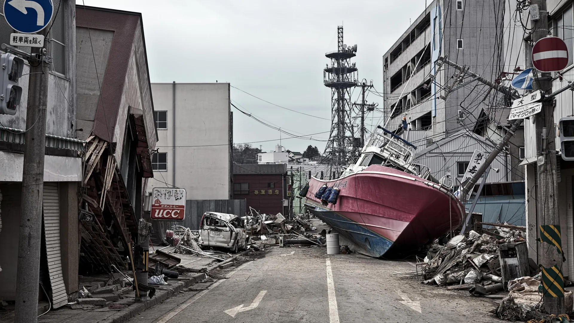
TOKYO / FLAGSTAFF, ARIZONA — More than a decade after the devastating Great East Japan Earthquake and Tsunami of March 11, 2011, an international team of geoscientists has solved one of modern seismology’s most perplexing mysteries. In a groundbreaking study published in the prestigious journal Science, researchers revealed that a hidden, ultra-soft layer of clay deep beneath the Pacific Ocean floor acted as a geological catalyst, supercharging the magnitude 9.1 megathrust earthquake and enabling an unprecedented displacement of the seafloor.
The discovery fundamentally challenges long-held assumptions about how subduction zones operate, rewriting textbooks on fault dynamics and offering crucial insights that could refine future hazard assessments and early-warning systems worldwide.
Main Facts: The Anatomy of a Megaquake
The 2011 Tohoku earthquake was one of the most powerful natural disasters ever recorded. Striking off the Pacific coast of Honshu, the seismic event released an incomprehensible amount of energy, triggering towering tsunami waves that breached seawalls, inundated coastal cities, and precipitated the catastrophic Fukushima Daiichi nuclear accident.
While scientists immediately understood that the disaster was caused by the sudden rupture of the megathrust fault where the Pacific Plate dives beneath the North American Plate, the sheer magnitude of the seafloor displacement left researchers baffled.
According to the new research, the primary culprit was a 100-foot-thick stratum of pelagic clay resting silently just beneath the seafloor of the Japan Trench. This unconventional layer of exceptionally soft, slippery sediment—accumulated over millions of years from the slow descent of microscopic marine organisms—acted like a pre-engineered "tear line" or a biological slip-sheet.
Sandwiched between vastly more rigid rock formations, this weak layer concentrated tectonic stress along an exceptionally narrow path. When the fault let go, the usual resistance that dampens shallow ruptures vanished. The fault tore all the way to the trench, causing the ocean floor to lurch horizontally and vertically by an astounding 130 to 200 feet.
To put this monumental movement into perspective, Christine Regalla, an associate professor in Northern Arizona University’s School of Earth and Sustainability and a co-author of the study, offered a stark visualization: "That’s equivalent to the entire area between Los Angeles and San Francisco moving 130 to 200 feet in just six minutes. We’ve never seen anything like that in the time we’ve been observing earthquakes. Based on what we understood, we didn’t think that could happen."
Chronology of Discovery: A Record-Breaking Scientific Expedition
Unearthing the mechanism behind the 2011 disaster required engineering feats as monumental as the geological forces they sought to study.
The Path to the Deep Seafloor
Most large earthquakes originate deep within the Earth’s crust, far from the ocean surface or dry land. For instance, the 2001 Nisqually earthquake in the Pacific Northwest—a magnitude 6.8 event—had a hypocenter roughly 32 miles beneath the surface. In contrast, the 2011 Japan earthquake ruptured to within roughly 15 miles of the seafloor, allowing the fault energy to break out with unmitigated force directly beneath the water column.
To discover why the 2011 rupture behaved so anomalously, an international cadre of more than a dozen geoscientists launched an ambitious exploratory campaign aboard the state-of-the-art Japanese scientific drilling vessel Chikyu.
Drilling into Record-Breaking Depths
Operating in the punishing environment of the western Pacific, the expedition drilled approximately 26,000 feet (nearly 8 kilometers) down through the ocean water and deep into the ocean floor to extract pristine core samples of the fault zone.
This technical triumph did not go unnoticed. Guinness World Records officially recognized the expedition as the deepest scientific ocean drilling project ever successfully completed. Back in laboratories around the world, structural analysis of these sediment cores unmasked the slippery pelagic clay layer, validating the hypothesis that local stratigraphy dictates fault behavior.
Supporting Data: The Mechanics of the Slip
The quantitative data recovered from the Chikyu core samples provide a sobering look at the physical properties of subduction zones.
- Depth of the Rupture: The 2011 fault break propagated significantly shallower than standard models predicted, reaching nearly to the physical edge of the ocean trench.
- Seafloor Displacement: Direct geodetic and seismic measurements confirmed a massive crustal shift of 130 to 200 feet, an energetic jolt that displaced colossal volumes of water and generated the devastating tsunami waves.
- Human and Economic Toll: The ensuing disaster claimed nearly 20,000 human lives, displaced hundreds of thousands of residents, and inflicted upwards of $200 billion in direct economic damage, making it one of the costliest natural disasters in modern history.
- Geological Extent: The newly identified pelagic clay deposit does not exist in an isolated pocket; it stretches continuously for hundreds of miles along the strike of the Japan Trench.
Patrick Fulton, an associate professor in Cornell University’s Department of Earth and Atmospheric Sciences and a co-author of the study, emphasized how geology acts as an architectural blueprint for catastrophe.
"At the Japan Trench, the geologic layering basically predetermines where the fault will form," Fulton noted. "It becomes an extremely focused, extremely weak surface, which makes it easier for ruptures to propagate all the way to the seafloor."
Official Responses and Global Implications
The findings have sent ripples through the global seismological community, prompting governments and academic institutions to re-evaluate seismic safety protocols across high-risk tectonic zones.
Because the pelagic clay layer spans vast distances along the trench, researchers warn that other segments of the subduction zone may harbor similar hidden vulnerabilities. This means regions previously thought to have lower risks of shallow-slip megathrust events may need to be upgraded in hazard models.
A Threat Without Borders
The implications of the study extend far beyond the shores of Japan. Tsunamis generated by shallow megathrust slips possess trans-oceanic momentum that can devastate distant coastlines within hours.
"An earthquake and tsunami in Japan doesn’t just impact people who live locally — it also impacts people at the ports and people who live across the ocean," Regalla explained, drawing attention to historical vulnerabilities in regions like Hawaii. "Think about Hawaii: Their most devastating tsunamis come from Japan and Alaska. These are truly global events."
Emergency management agencies in nations ringing the Pacific "Ring of Fire"—including the United States, Chile, New Zealand, and Indonesia—are already reviewing how these insights into fault mechanics might alter tsunami modeling for coastal infrastructure.
Future Forecasts and Preparedness
Armed with a clearer picture of what makes a subduction zone prone to catastrophic, shallow-slip earthquakes, scientists hope to transition from reactive disaster response to proactive hazard mitigation.
Upgrading Engineering and Policy
The ultimate goal of the research is to supply urban planners, structural engineers, and policymakers with precise data regarding where maximum seafloor displacement is mechanically possible. This intelligence will enable authorities to:
- Strengthen Building Codes: Design skyscrapers, bridges, and industrial facilities to withstand longer-duration, high-frequency ground motions.
- Improve Coastal Defense Infrastructure: Re-evaluate the height, placement, and structural integrity of seawalls and breakwaters in vulnerable coastal zones.
- Update Evacuation Protocols: Design more efficient, high-capacity evacuation routes for coastal communities with limited warning times.
- Refine Early Warning Systems: Integrate fault-zone composition metrics into real-time seismic monitoring algorithms to better predict tsunami wave heights within minutes of an initial tremor.
Despite Japan’s status as a global pioneer in earthquake engineering and disaster readiness, the 2011 event proved that nature can still surpass human expectations.
"Japan is one of the world leaders in earthquake and tsunami preparation, but even they weren’t prepared for what happened in 2011," Regalla reflected. "We all need to gain a better understanding of where these events might happen in the future. Only then can we make emergency plans that will keep everyone safe."
As researchers continue to analyze the data from the deepest ocean drilling project in history, humanity takes one more step toward demystifying the volatile forces shifting beneath our feet—turning silent layers of ancient clay into vital knowledge for saving future lives.
