


September 25, 2026 — For generations, outdoor enthusiasts looking at long-distance trekking in the Eastern United States have gravitated toward the well-trodden, legendary paths of the Appalachian Trail. Yet, those intimately familiar with the Keystone State know that a far wilder, more rugged network of paths snakes across its rocky ridgelines and deep, isolated forests.
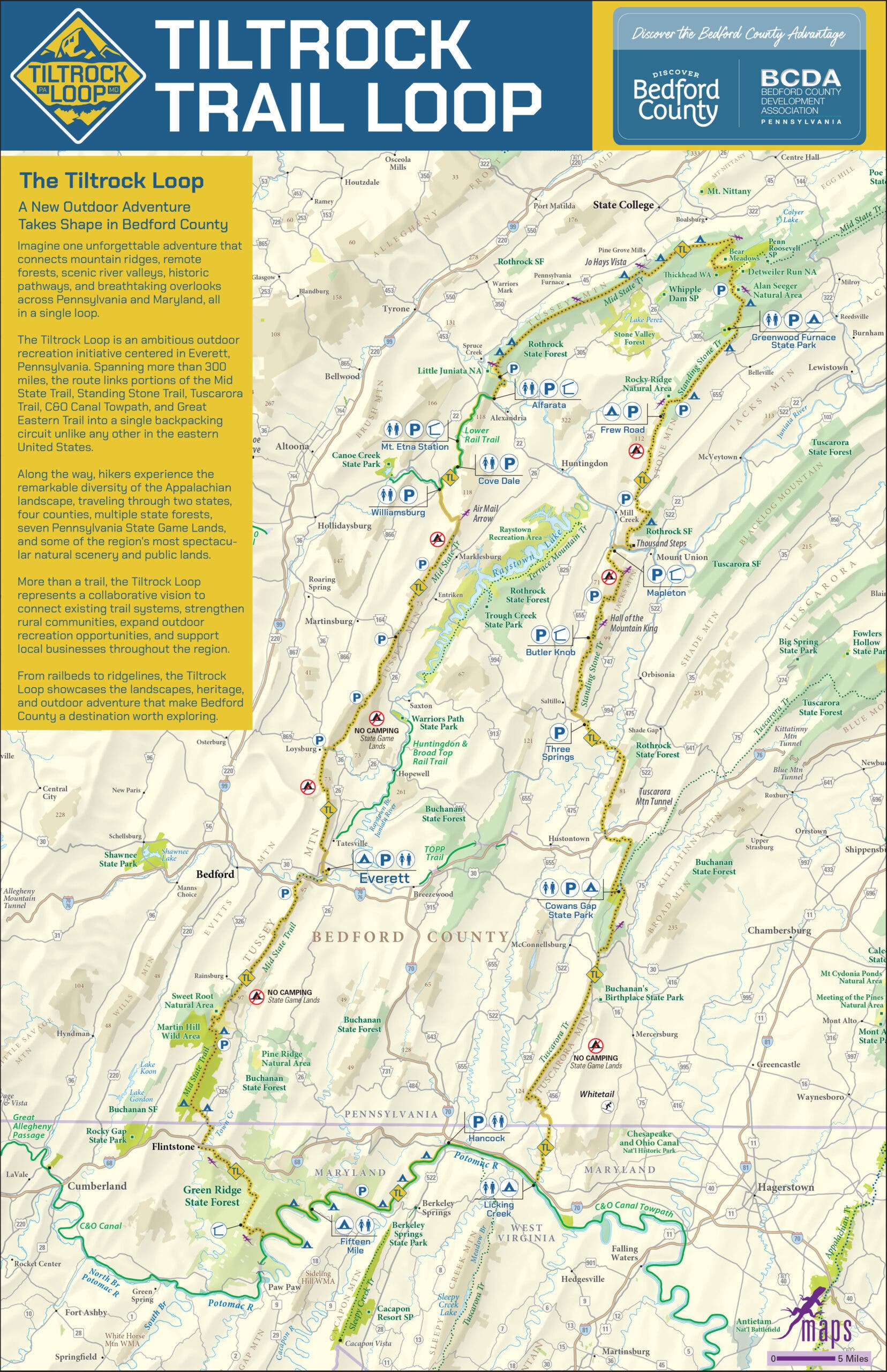
Enter the Tiltrock Loop: a newly established 300-mile continuous backpacking route spanning south-central Pennsylvania and northern Maryland. Seamlessly stitching together portions of five pre-existing, historic trails, this ambitious loop offers modern thru-hikers a rigorous, highly scenic alternative to the traditional linear routes of the East Coast.
Crucially, the route comes with a pristine slate and a historic bragging right: as of its launch, not a single person has logged a completed thru-hike. For adventurous backpackers looking to make outdoor history, the inaugural season presents a rare opportunity to claim an absolute blank slate—and, as local tourism officials happily point out, an automatic Fastest Known Time (FKT).
Main Facts: Anatomy of a Modern Masterpiece
The Tiltrock Loop is designed to hit the "sweet spot" for modern backpackers: long enough to feel like a true wilderness expedition, but manageable enough that hikers do not need to quit their jobs or abandon their everyday lives to complete it.

The Tiltrock Loop at a Glance
- Distance: 300 miles
- Route Type: Continuous loop
- Geographic Scope: South-central Pennsylvania and northern Maryland
- Total Elevation Gain: 33,372 feet
- Highest Elevation: 2,727 feet
- Recommended Trailhead (Start/End): Everett, Pennsylvania
- Terrain: Appalachian ridges, deep forests, and river valleys
- Estimated Thru-Hike Duration: Approximately 30 days
Unlike linear long trails—which notoriously require complicated, multi-vehicle shuttles or agonizing thumbs-up stints hitchhiking along remote dirt roads—the circular layout of the Tiltrock Loop eliminates logistical nightmares. Hikers can step off from their home base, complete the grand tour of the region’s topographies, and arrive precisely back where they started.
Chronology: How a New Thru-Hike Is Born
Every great trail begins with a spark of inspiration, and the Tiltrock Loop is no exception. Taking its evocative name from the slanted, dramatic Allegheny ridgelines that define the regional geography, the project started with a lightbulb moment from avid local hiker Mike Teeter.
The Accidental Discovery
While studying regional trail maps, Teeter noticed that a recent rerouting of the expansive 1,800-mile Great Eastern Trail had inadvertently set the stage for something bigger. By looking at how regional arteries connected, he realized that a massive loop could be forged by combining the C&O Canal Towpath and Mid State Trail to the west with the Tuscarora and Standing Stone trails to the east.
Teeter envisioned a backpacking route that would breathe fresh air into these historic, yet frequently overlooked, paths. What followed was a passionate grassroots campaign spearheaded by Teeter alongside the Bedford County Outdoor Recreation Alliance.

A Rare Alignment of Stakeholders
Developing a 300-mile trail network typically requires navigating a labyrinth of red tape, bureaucratic delays, and jurisdictional friction. The Tiltrock Loop, however, defied expectations through an unprecedented wave of cross-agency cooperation.
Organizers had to coordinate with five distinct trail associations, multiple state agencies, and private land management groups. Yet, according to Jennifer Marsh, head of the Bedford County Development Association, the bureaucratic hurdles vanished beneath an immediate wave of enthusiasm.
"How often do you have everyone in a group saying, ‘Yes, let’s do this!’?" Marsh reflected, highlighting the rare alignment of five major trail stakeholder groups representing the Great Eastern, Mid State, Tuscarora, Standing Stone, and C&O trails.
Supporting Data: Blending Five Trails Into One Loop
The engineering feat of the Tiltrock Loop lies in how it seamlessly bridges disparate outdoor landscapes. When Teeter first presented his blueprint to regional experts, the consensus was immediate: by tying these fragments together, hikers would gain access to some of the most visually stunning and ecologically diverse terrain in the Mid-Atlantic.
A Tapestry of Trails and Terrain
- The Ridgelines and Valleys: The route takes backpackers across punishing, beautiful Allegheny ridgelines, demanding a cumulative elevation gain of 33,372 feet—a vertical challenge that rivals much taller western peaks pound-for-pound.
- Industrial History: The trail is a living museum. Hikers pass the crumbling remnants of Pennsylvania’s 19th- and early 20th-century mining operations, as well as eerie, abandoned infrastructure from a grand railway project that was never completed.
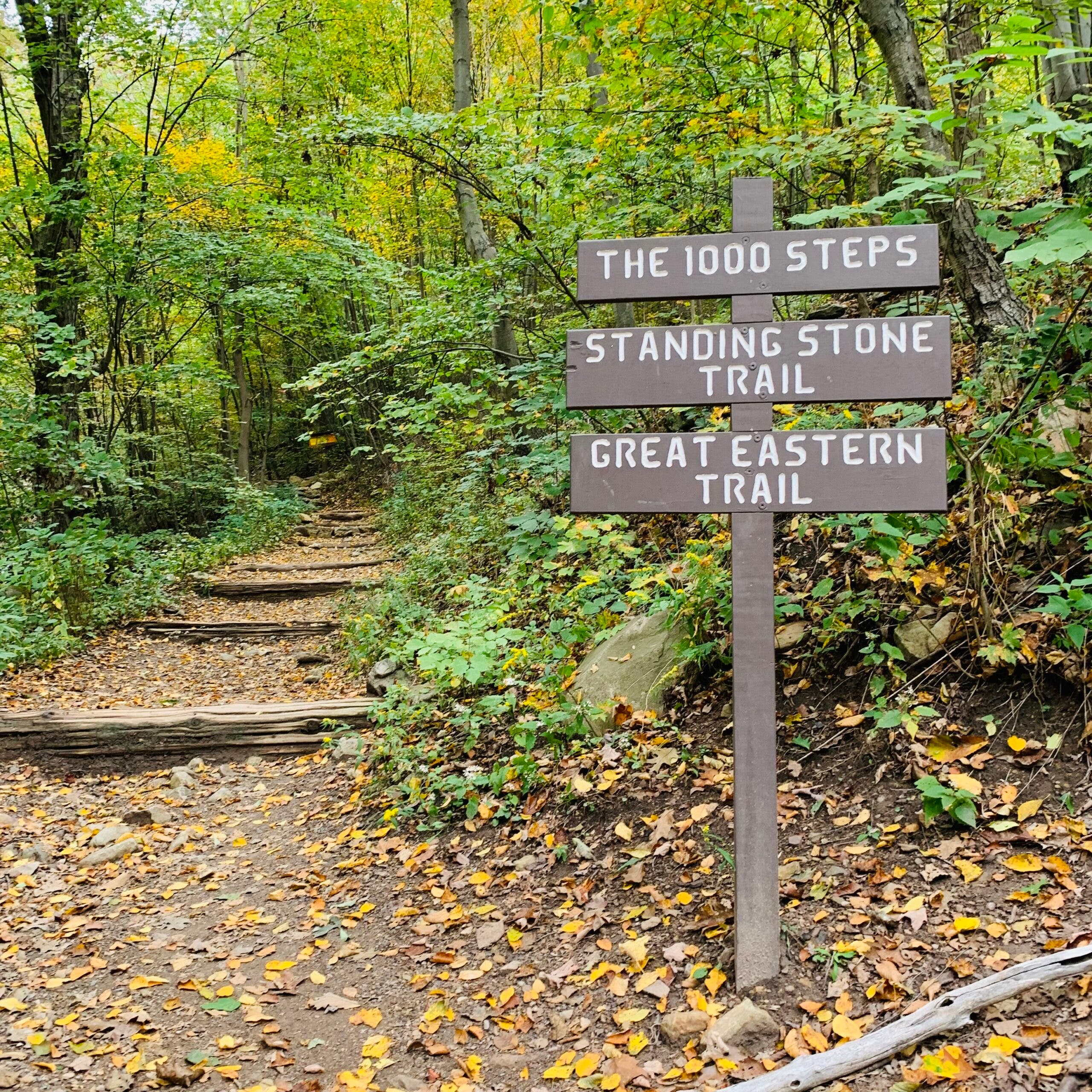
- Iconic Landmarks: From the famous "Thousand Steps" on the Standing Stone Trail to sweeping vistas atop the Standing Stone Overlooks, the trail delivers unforgettable visual payoffs.
Navigational Innovations and Logistics
To ensure that America’s newest long trail doesn’t overwhelm its first wave of visitors, organizers partnered with Purple Lizard Maps—a Pennsylvania-based cartography company famous for its hyper-detailed, adventure-focused maps. The official Tiltrock Loop map features the company’s signature lizard icon, marking critical spots such as exceptional viewpoints, vital water sources, campsite availability, and upcoming resupply towns.
Because water availability along the Appalachian ridgelines can fluctuate wildly depending on seasonal weather patterns, creators recommend that hikers carry a minimum of three liters of water daily, alongside three to five days of food rations.
Accommodations along the route run the gamut. Hikers will encounter a hybrid system of backcountry camping zones, established trail shelters, and primitive sites. Strict adherence to local land regulations—particularly within Pennsylvania State Game Lands—is clearly outlined on the official map to protect the delicate ecology of the region.
Official Responses: Community Investment and Economic Impact
While backpackers often seek solitude, the economic and social backbone of any great long trail is its gateway communities. The creators of the Tiltrock Loop were intentional about designing a route that directly benefits the towns nestled in the valleys below the ridgelines.
The Vision of Bedford County Leaders
"We weren’t interested in creating another reason to simply drive through Bedford County; we wanted to give people a reason to experience it mile by mile," said Brooke Kelly, executive director of Discover Bedford County. "The Tiltrock Loop connects some incredibly wild places, but it also connects hikers to the communities surrounding them. That combination is what makes this trail different."
Everett, Pennsylvania: The Ultimate Trail Town
Anchoring the entire 300-mile experience is Everett, Pennsylvania. Historically known as a welcoming haven for weary travelers along the remote Mid State Trail, Everett has leaned heavily into its role as the official base camp for the Tiltrock Loop.
The town provides everything a long-distance backpacker dreams of after weeks in the wilderness:
- Family-owned restaurants and local pubs serving hot meals and cold drinks.
- Comfortable lodging options for hikers taking a zero-day.
- Essential town amenities, including a fully equipped laundromat.
Beyond serving as the start and finish line for a full thru-hike, Everett acts as a launchpad for shorter excursions. Segments like the Everett Ridge section and the family-friendly Tenley Park Loop offer bite-sized introductions to the region’s rugged topography for weekend warriors and day-trippers.

Implications: A New Era for Pennsylvania Outdoor Recreation
The debut of the Tiltrock Loop marks a pivotal moment for regional tourism and the broader American thru-hiking community. As traditional long-distance routes like the Appalachian Trail and Pacific Crest Trail face mounting congestion and permit restrictions, the emergence of thoughtfully engineered, regional alternative loops provides a vital pressure valve.
Furthermore, the collaborative blueprint used to forge the Tiltrock Loop offers a model for future trail development across the United States. By uniting disparate trail maintenance clubs, local municipal governments, and regional economic development organizations under a single banner, communities can transform overlooked local pathways into world-class adventure destinations.
For the daring soul willing to lace up their boots this season, the stakes are high and the glory is unprecedented. As Jen Marsh playfully noted when pitching the adventure to prospective backpackers: anyone willing to tackle the route right now won’t just be seeing uncharted territory—they’ll instantly hold the Fastest Known Time.
Discover the unexpected in Bedford County. Tucked into Pennsylvania’s Allegheny Mountains, Bedford County is made for discovery. Hike rugged trails, paddle scenic waterways, explore centuries of history, savor local flavors, and recharge at one-of-a-kind places to stay. Here, outdoor adventure, rich history, and unexpected experiences are closer than you think.
