

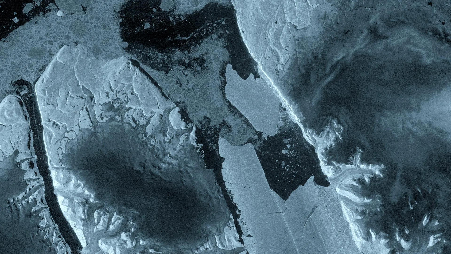
COPENHAGEN/OTTAWA — In a dramatic illustration of the rapid and unfolding transformations reshaping Earth’s polar regions, Europe’s Copernicus Sentinel-1 satellite mission has documented a monumental calving event in northwest Greenland. On August 4, 2026, a staggering 76-square-kilometer section of the Petermann Glacier’s floating ice tongue broke away from the mainland, marking the glacier’s largest ice loss since 2012 and the most significant calving event recorded across the entire Arctic since 2020.
The newly birthed tabular iceberg—colloquially referred to as an "ice island"—is roughly the equivalent of Manhattan in surface area and is estimated to be up to 150 meters thick. While such massive, flat-topped tabular icebergs are a relatively common occurrence in the rugged waters of the Southern Ocean surrounding Antarctica, they are exceptionally rare in the Arctic. This rarity has elevated the Petermann event to a prime case study for an international collective of glaciologists, oceanographers, and climate scientists seeking to understand the mechanical forces destabilizing Earth’s northernmost ice sheets.
Beyond its scientific gravity, the sudden emergence of this colossal ice mass poses immediate, tangible challenges. Maritime authorities, shipping lanes, and offshore infrastructure operators across the Arctic are now on high alert as the drifting monolith begins its unpredictable journey out of the fjord and into open waters.
Main Facts: Anatomy of a Mega-Calving
The calving of Petermann Glacier on August 4, 2026, was not an isolated meteorological anomaly, but the violent culmination of structural failures that have been brewing beneath the surface for months.
- The Scale of Loss: A single section spanning 76 square kilometers detached from the eastern flank of the glacier’s floating ice tongue.
- Historical Context: This represents the largest single loss of floating ice from Petermann since 2012 and the largest Arctic calving event overall since 2020.
- Physical Dimensions: The resulting tabular iceberg is comparable in area to the island of Manhattan, with an estimated vertical thickness reaching up to 150 meters.
- The Technology Behind the Discovery: The breakup was captured in high-resolution detail by the European Space Agency’s (ESA) Copernicus Sentinel-1 mission, utilizing advanced synthetic aperture radar (SAR) capable of peering through persistent Arctic cloud cover and operating seamlessly through the polar night.
- Imminent Further Risks: According to researchers closely monitoring the region, the danger has not passed. Two additional massive ice islands—with estimated surface areas of roughly 97 and 87 square kilometers, respectively—are poised to detach as existing rifts continue to propagate across the remaining vulnerable sections of the floating ice tongue.
Chronology of a Breakup: From Deep Fractures to Open Water
To fully grasp how quickly modern polar ice can transition from stability to catastrophic failure, scientists have reconstructed the timeline leading up to the August 4 event, relying heavily on continuous satellite surveillance and high-frequency radar interferometry.
Spring 2026: The Invisible Stressors
Months before the first visible cracks made headlines, high-resolution interferometric observations collected over Petermann Glacier in April revealed severe internal deformation and deep-seated fractures proliferating within the floating ice tongue. These radar measurements acted as an early-warning system, giving glaciologists a microscopic view of structural strains that were developing long before any surface-level displacement was noticeable.
August 3, 2026: Rapid Deterioration
The final hours of the ice tongue’s integrity unfolded at a dizzying pace. Radar images captured by Sentinel-1 on August 3 showed marked, accelerated structural deterioration right along the central axis of the floating ice tongue. The stress within the ice was reaching its absolute breaking point, driven in part by ocean tides flexing the massive ice shelf against underlying bathymetry.
August 4, 2026: The Calving Event
Just 24 hours after the intense central deterioration was flagged, the massive structural failure materialized. The eastern side of the ice tongue completely fractured, separating a 76-square-kilometer slab of ancient ice from the parent glacier.
The Tandem Phase Advantage
This near-real-time capture was made possible by a unique convergence of satellite operations. The high-detail interferograms were generated thanks to one-day repeat synthetic aperture radar observations gathered during the joint commissioning phase of the Sentinel-1C and Sentinel-1D satellites. This rare tandem configuration allowed researchers to track how cracks spread across the ice shelf and how the ice surface responded to ocean tides with unprecedented temporal resolution.
Supporting Data and International Collaboration
The monitoring of Petermann Glacier is not a localized effort; it is the product of a robust, multi-year international partnership. An interdisciplinary research team has maintained a vigilant watch over the glacier since 2019 under an initiative partially funded by ESA’s FutureEO ARCTEX project.
The collaboration bridges major academic institutions and government agencies across North America and Europe, including:
- University of Ottawa (Canada)
- University of Stirling (United Kingdom)
- Lancaster University (United Kingdom)
- University of Leeds (United Kingdom)
- Canadian Ice Service of Environment and Climate Change Canada
Over the years, this collaborative network has tracked the steady, alarming expansion of fractures across Petermann, building a comprehensive dataset that proves the glacier’s floating ice tongue has been sliding toward systemic instability.
Historically, Petermann has demonstrated a cyclical nature of major calving events, having produced colossal ice islands in 2008, 2010, and 2012. However, in the 14 years following the 2012 fracture, the floating ice tongue remained relatively quiescent, experiencing only minor, localized calving episodes. This long period of relative stability lulled some observers into a false sense of security, making the 2026 event a stark reminder of the non-linear tipping points inherent to modern climate dynamics.
Official Responses and Scientific Perspectives
The scientific community has responded to the event with a mixture of long-anticipated validation and profound concern regarding the accelerated state of Arctic transformation.
Adam Garbo, a PhD student at the University of Ottawa who has spent years analyzing the glacier’s health, noted the historical significance of the moment:
"Petermann Glacier has long been one of Greenland’s largest remaining ice tongues. We’ve anticipated this break for years, and seeing it finally happen is remarkable. It’s a powerful reminder of how quickly these systems can change."
Dr. Anna Crawford of the University of Stirling emphasized the broader climatological implications of studying Arctic ice islands:
"While large, tabular icebergs are relatively common in the Southern Ocean around Antarctica, Arctic ice islands are far rarer. By studying Arctic ice islands, we will gain knowledge that can be transferred across polar regions. This is critical for understanding how the calving and deterioration of ice islands impact glacier dynamics, sea-level rise, and the ocean environment."
Highlighting the technological triumphs that allowed scientists to witness the breakup as it unfolded, Molly Hammond, a PhD student at the University of Leeds who processed the Sentinel-1 radar data, stated:
"The changes we observed on Petermann Glacier were occurring very rapidly in the lead-up to the iceberg calving event, so it was incredibly exciting to monitor the crack propagation with interferometry in near-real time. This has demonstrated the incredible value of one-day repeat synthetic aperture data."
From the institutional perspective of the European Space Agency, Martin Wearing underscored the irreplaceable role of continuous spaceborne observation:
"This type of large tabular iceberg is relatively rare in the Arctic, making this calving event a unique opportunity to study how such a vast ice mass drifts, evolves, and eventually breaks apart. Satellite missions such as Sentinel-1 provide the systematic, long-term observations needed to track these changes, helping scientists better understand the processes driving calving and the wider impacts on the polar environment, and ultimately the Earth system as a whole."
Wearing added his praise for the collaborative funding framework: "Alongside Europe’s excellent Earth observation missions, we are pleased to see the ARCTEX project supporting this work and enabling further scientific investigation of the rapidly evolving Arctic."
Implications: Environmental, Scientific, and Maritime Risks
The separation of a Manhattan-sized block of ice from Greenland’s northwest coast carries far-reaching consequences that stretch well beyond glaciology textbooks.
1. Glacier Dynamics and Sea-Level Rise
While the ice that broke away was already floating—meaning its immediate detachment does not cause an immediate, one-to-one sea-level rise (similar to ice cubes melting in a glass of water)—the loss of the floating ice tongue removes a vital structural "buttress." Without this tongue exerting back-pressure, the grounded glaciers feeding the Petermann system can accelerate their flow toward the sea, ultimately dumping massive volumes of land-based ice into the ocean and directly contributing to global sea-level rise.
2. Oceanographic Shifts
As the newly formed tabular iceberg drifts away and eventually begins to break apart, it will discharge vast quantities of fresh water into the surrounding marine ecosystem. Such localized freshwater pulses can alter local ocean stratification, marine currents, and nutrient distribution, impacting everything from microscopic phytoplankton to apex marine predators.
3. Immediate Navigational Hazards
On a practical, human-centered level, the calving event presents an immediate operational headache for Arctic navigation. Environment and Climate Change Canada, alongside other international maritime monitoring agencies, is actively tracking the trajectory of the colossal ice island.
Ice masses of this magnitude do not simply vanish; they can persist in Arctic ocean currents for years, slowly fragmenting into smaller, highly hazardous blocks of ice. These smaller daughterbergs become progressively harder to detect by standard shipboard radar systems, posing a severe, lingering threat to commercial shipping lanes, fishing vessels, and offshore industrial infrastructure operating in northern waters.
As researchers continue to deploy satellite imagery, aerial reconnaissance, and active tracking beacons to follow the path of the Petermann ice island, the scientific community remains on edge. With two more colossal fractures waiting in the wings of the glacier’s battered ice tongue, the story of Petermann Glacier is far from over—serving as an unfolding chronicle of a changing planet written in real-time across the Arctic ice.
