

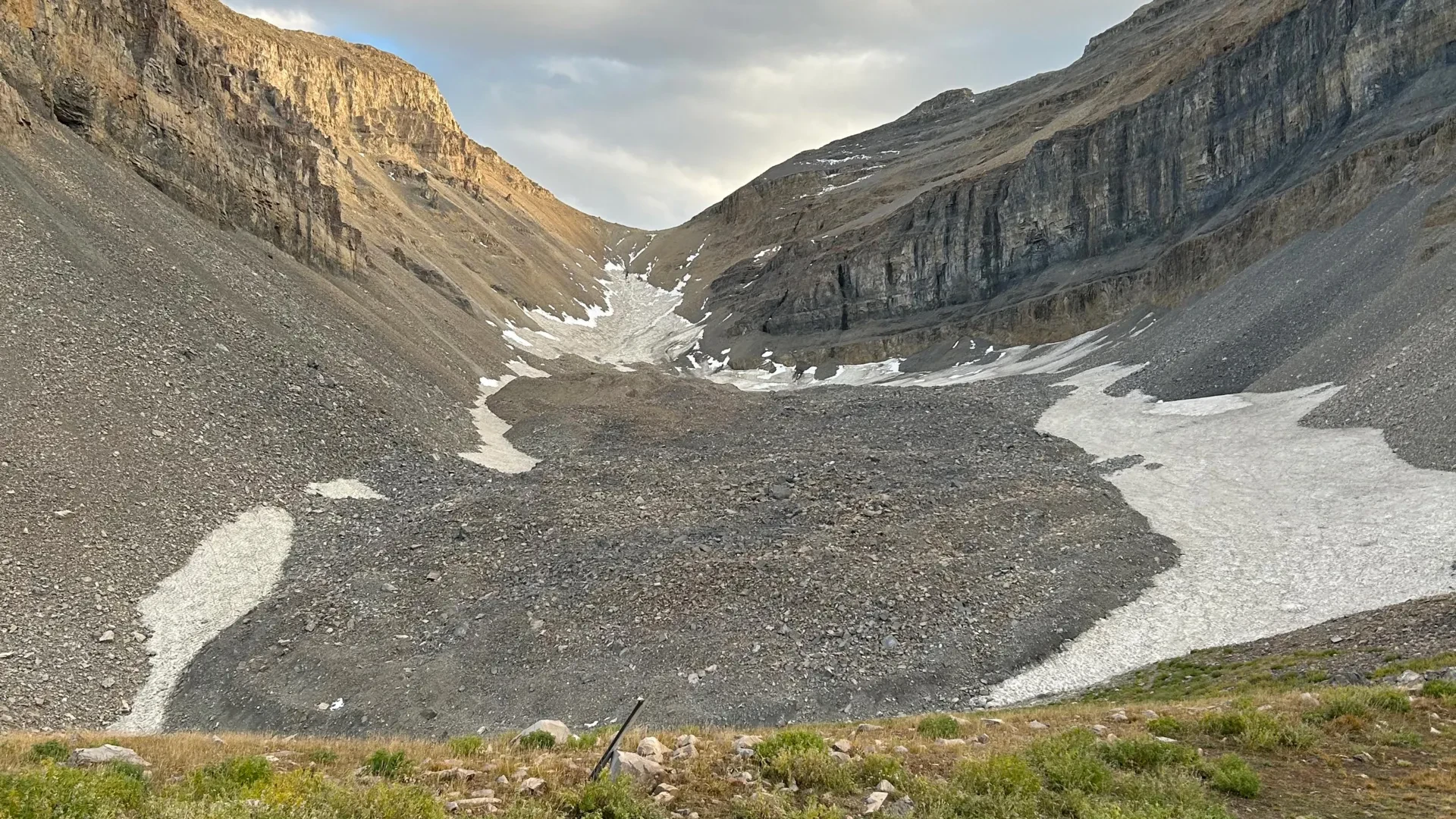
To the casual hiker traversing the rugged high-elevation trails of Utah’s Wasatch and Uinta ranges, the landscape can appear deceptively barren. Beneath boots lie sprawling, chaotic fields of loose rock, talus, and jagged debris that look more like ancient landslide scars than living hydrological features. For generations, these rock glaciers were often dismissed as inert piles of rubble—geological leftovers of little consequence to the state’s modern water supply.
That paradigm is rapidly shifting.
In a pair of groundbreaking studies, a team of University of Utah geologists has peeled back the rocky exterior of one of the state’s most prominent alpine features: the Timpanogos Rock Glacier, nestled beneath the towering, jagged summit of Mount Timpanogos between Salt Lake City and Provo. Utilizing a novel combination of high-precision gravity measurements, advanced computing, and rigorous field work, the researchers have revealed that this seemingly dry pile of stones is actually an astonishingly rich subterranean reservoir.
The Timpanogos Rock Glacier is composed of roughly 83% frozen water and only 17% loose rock. Hidden deep beneath 120 feet of protective surface debris lies an estimated 1.5 million cubic meters of solid ice—a volume roughly equivalent to the Great Pyramid of Giza in Egypt, or enough water to fill approximately 600 Olympic-sized swimming pools.
This revelation is more than an academic curiosity. By establishing a new methodology to image the internal architecture of rock glaciers in three dimensions, the University of Utah team has unlocked a blueprint for evaluating hidden mountain water reserves across the American West and around the globe.
Main Facts: Decoding the Timpanogos Rock Glacier
Unlike conventional valley glaciers—which feature sweeping, visible rivers of blue ice exposed directly to the elements—rock glaciers are armored by thick layers of surface detritus. They creep slowly down steep mountain valleys, insulated from warming summer temperatures by the very rocks that blanket them.
The recent investigations into the Timpanogos Rock Glacier were spearheaded by a multidisciplinary team including lead author and former graduate student Bronson Cvijanovich, geophysics professor Michael Thorne, and glaciology professor Leif Anderson. Their work bridges the gap between surface observations and subterranean reality, yielding several core discoveries:
- Staggering Ice Content: The Timpanogos Rock Glacier is shockingly ice-rich, holding an 83-to-17 ratio of ice to rock.
- Total Volume: The formation contains approximately 1.5 million cubic meters of frozen water.
- Global and Regional Scaling: Across Utah, satellite mapping has identified 836 rock glaciers. Utilizing data gathered from Mount Timpanogos, researchers estimate that Utah’s rock glaciers collectively harbor roughly 1 gigaton of water—equivalent to about 815,000 acre-feet. Globally, the roughly 50,000 known rock glaciers may contain a staggering 48 gigatons of water.
- Origins: Mathematical modeling developed by the team indicates these formations are not relic remnants of the last Ice Age (which peaked 18,000 to 21,000 years ago). Instead, they are dynamic reservoirs that accumulated over the millennia following the retreat of major Ice Age glaciers.
Chronology: How the Breakthrough Research Unfolded
The unveiling of Mount Timpanogos’s hidden ice was a multi-year scientific endeavor that required meticulous field execution and months of heavy computational analysis.
The Field Campaigns (Fall 2024)
The physical heart of the project took place during the autumn of 2024. Bronson Cvijanovich led a series of grueling field expeditions up to the Timpanogos Rock Glacier, hauling sensitive, highly calibrated scientific instruments above Emerald Lake.
Rather than drilling or coring—methods that are invasive, logistically difficult, and environmentally disruptive in fragile alpine zones—the team relied on a state-of-the-art gravimeter. Across six distinct field excursions, Cvijanovich collected gravity measurements at 232 precise locations. The data points were meticulously arranged in a uniform grid across the glacier, with each station spaced roughly 25 meters (about 80 feet) apart.
Data Processing and Correction
Gathering raw field data was only the initial hurdle. Gravimeters are remarkably sensitive instruments, capable of detecting minute changes in gravitational pull caused by variations in Earth’s mass density. However, this means they also register external interference.
Before the team could isolate the signal of the buried ice, they had to mathematically strip away gravitational noise caused by:
- The changing positions and gravitational pulls of the sun and the moon.
- Subtle topographic variations, including local terrain undulations.
- Differences in latitude and elevation across the mountain slope.
3D Bayesian Inversion (Late 2024 – 2025)
Once the gravitational data was thoroughly cleaned, Thorne and the research team deployed a cutting-edge computational approach utilizing Bayesian statistics.
"We spent months of computation time doing the imaging with our new techniques," Thorne explained. By analyzing how gravitational acceleration decreased over areas with thicker subsurface ice—owing to the dramatic difference in mass density between the heavy surrounding mountain rock and the much lighter subterranean ice—the computer generated a high-resolution, three-dimensional model of the glacier’s interior.
Publication Timeline
The scientific community received these findings in stages across two major publications:
- April 2, 2026: The first paper, focusing on how rock glaciers form and the mechanics of mass addition, was published in Geophysical Research Letters. Led by Stanford undergraduate and former University of Utah summer researcher Isaiah Davies, this study detailed how eroding headwalls drop debris onto persistent snowpacks, preserving them beneath insulating blankets of rock.
- August 26, 2026: The definitive structural study detailing the 3D Bayesian inversion of the gravity data and the precise internal ice content of the Timpanogos Rock Glacier was published in the Journal of Geophysical Research.
Supporting Data: The Physics of Gravity Imaging
To understand why this research represents a major technological leap, one must look at the limitations of traditional remote sensing. Satellite imagery and aerial photography are exceptional tools for mapping the surface footprint of a rock glacier. They can reveal flow structures, surface ridges, and the boundaries of debris fields. However, satellites are entirely blind to depth and internal composition; they cannot tell a scientist whether a rock glacier is a solid core of ice wrapped in a thin veneer of stones, or merely a hollow pile of boulders with virtually no ice inside.
Traditionally, answering questions about internal structure required expensive seismic surveys or destructive core-drilling operations. The University of Utah team’s gravimetric method bypasses these obstacles.
+---------------------------------------------------------------+
|                 GRAVITY IMAGING METHODOLOGY                   |
+---------------------------------------------------------------+
|  1. Field Grid: 232 stations spaced 25 meters apart           |
|  2. Tool: High-precision gravimeter measuring density         |
|  3. Variable Filter: Sun, moon, terrain, & elevation removed  |
|  4. Computation: 3D Bayesian statistical inversion            |
|  5. Result: High-resolution map of subterranean ice depth     |
+---------------------------------------------------------------+
The underlying physics relies on density contrasts. Mount Timpanogos is composed of dense, heavy alpine rock. The frozen water trapped inside the adjacent rock glacier has a significantly lower mass density. When the gravimeter is carried across areas where the ice layer is thickest—reaching down as far as 120 feet—the instrument registers a distinct, measurable decrease in gravitational acceleration.
By scaling these point-source gravity measurements across the 232-grid system, the researchers were able to "see" inside the mountain much like a medical CT scanner maps bone and tissue within the human body.
Official Perspectives: What the Researchers Say
The implications of this hidden subsurface ice have stunned even seasoned geologists. The discovery alters our understanding of alpine hydrology in the Intermountain West, particularly in semi-arid states like Utah where water management is an ongoing, high-stakes challenge.
"There’s a lot of ice that’s hidden in Utah’s mountains," said glaciology professor Leif Anderson. "When we are high in the mountains and walking across loose rocks or rubble, you don’t realize there could be 120 feet of ice buried beneath your feet."
Anderson and his colleagues emphasize that these formations are actively maintained by the very processes that tear the mountains down. In the Wasatch Range, steep headwalls undergo continuous erosion, shedding rock and talus onto persistent snowpacks in high-altitude cirques.
"In the Wasatch, the mountains themselves are eroding and burying the snow, and that’s why the rock glaciers exist," Anderson noted. The mathematics developed by the team demonstrate that this continuous deposition of debris acts as a thermal blanket, insulating accumulated snow from summer solar radiation and allowing it to compact, recrystallize, and persist for millennia.
Bronson Cvijanovich, lead author of the structural study, highlighted the surprising purity of the formation. "Timpanogos Rock Glacier is surprisingly ice rich. It is 83% ice and 17% loose rock," he stated.
Geophysicist Michael Thorne underscored the rigorous nature of the computational modeling required to bring these hidden reserves to light. "There is a large contrast in mass density between the rock that makes up Mount Timpanogos and the much lower density ice that is in rock glacier adjacent to it," Thorne explained. "When we measure the gravitational acceleration over the rock glacier, we see a larger decrease in that gravitational acceleration as we make measurements over areas with thicker ice."
Implications: A Vital Mountain Water Reserve for the Future
As climate patterns shift and traditional winter snowpacks in the American West become increasingly vulnerable to rising temperatures and early melts, scientists are casting a wider net to understand all components of regional hydrology.
While conventional glaciers in the Rocky Mountains have been shrinking rapidly over the past century, rock glaciers possess a natural survival mechanism. Because they are capped by thick layers of rock debris, they are buffered against atmospheric warming to a degree that exposed ice simply cannot match. This protective armor allows them to act as long-term, stable hydrological buffers, slowly releasing meltwater down mountain watersheds during late-summer dry spells when water is most desperately needed downstream.
The scaling calculations performed by the University of Utah team suggest that the implications stretch far beyond the borders of Utah. If the 50,000 documented rock glaciers globally hold an estimated 48 gigatons of water—equivalent to 1 billion metric tons per gigaton, or enough to fill 400,000 Olympic swimming pools—they represent a massive, largely uncounted global water reserve.
Within Utah alone, the roughly 1 gigaton of water locked within the state’s 836 identified rock glaciers amounts to approximately 815,000 acre-feet of potential resource. For water managers, ecologists, and policy planners in Salt Lake City, Provo, and surrounding communities, quantifying this hidden subterranean asset is a crucial step toward securing a resilient water future.
The research was made possible through collaborative financial and logistical support from the U.S. Geological Survey, the National Science Foundation, the University of Utah’s Wilkes Center for Climate Science & Policy, the U’s Office of Undergraduate Research, and the Summer Program for Undergraduate Research.
As scientists continue to deploy gravity inversion modeling to other rock glaciers across the Wasatch, Uinta, and La Sal ranges, the true extent of Utah’s frozen underground wealth is finally coming to light—proving that beneath the desolate surface of mountain talus fields lies a hidden lifeline for the arid West.
