

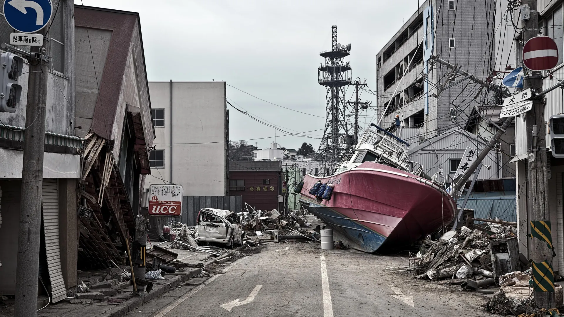
TOKYO / FLAGSTAFF, ARIZONA — More than a decade after a wall of seawater reshaped the coastline of northeastern Japan, triggered a nuclear crisis, and claimed nearly 20,000 lives, scientists have finally answered one of seismology’s most haunting questions: Why was the 2011 Tōhoku earthquake so catastrophically powerful?
In a groundbreaking study published in the journal Science, an international team of geoscientists has revealed that the staggering destruction of March 11, 2011, was not merely the result of standard tectonic plate friction. Instead, it was facilitated by a hidden, microscopic accomplice lurking thousands of feet beneath the Pacific Ocean—a thin, hyper-slippery layer of ancient clay.
This newly discovered geologic "tear line" allowed the fault to rupture all the way to the seafloor, shifting the ocean bottom by an unprecedented margin and generating the colossal tsunami that overwhelmed Japan’s coastal defenses. By exposing the mechanical secrets of the Japan Trench, the discovery provides seismologists with crucial new tools to reassess seismic hazards, refine early-warning systems, and better protect vulnerable coastal communities worldwide.
Main Facts: Anatomy of a Historic Disaster
On March 11, 2011, a magnitude 9.1 megathrust earthquake struck off the Pacific coast of Honshu, Japan. It remains one of the most powerful earthquakes ever recorded by modern instruments. While ground shaking caused extensive structural damage, the true catastrophe came from the ocean: a towering tsunami with run-up heights reaching up to 130 feet in some areas. The disaster devastated towns, crippled the Fukushima Daiichi Nuclear Power Station, and caused more than $200 billion in economic losses.
For years, seismologists struggled to reconcile the physical scale of the disaster with established geological models. Typically, the massive ruptures that spawn major earthquakes occur deep underground, miles beneath the Earth’s crust. For instance, the 2001 Nisqually earthquake in the Pacific Northwest—a magnitude 6.8 event—originated roughly 32 miles beneath the seafloor.
The 2011 Tōhoku earthquake defied these textbook parameters. The rupture propagated remarkably close to the surface, reaching just 15 miles—and in places, even shallower—beneath the ocean floor. This shallow slip allowed the overlying tectonic plates to shift with violent, unrestrained freedom.
The resulting displacement of the seafloor was extraordinary: measurements indicate that the earth moved horizontally and vertically by an astonishing 130 to 200 feet.
“That’s equivalent to the entire area between Los Angeles and San Francisco moving 130 to 200 feet in just six minutes,” said Christine Regalla, an associate professor in Northern Arizona University’s School of Earth and Sustainability and a co-author of the study. “We’ve never seen anything like that in the time we’ve been observing earthquakes. Based on what we understood, we didn’t think that could happen.”
Chronology of a Discovery: Drilling to the Bottom of the Earth
To solve the mystery of how a fault could slip so dramatically near the surface, researchers had to go straight to the source. Led by Regalla alongside more than a dozen international scientists, the research team launched an ambitious scientific expedition aboard the state-of-the-art Japanese research vessel Chikyu.
The mission required technological feats that pushed the boundaries of modern engineering. Operating in deep ocean waters, the expedition drilled approximately 26,000 feet (nearly 8 kilometers) down into the ocean floor of the Japan Trench to recover pristine core samples of the fault zone. This monumental achievement was officially recognized by Guinness World Records as the deepest scientific ocean drilling project ever completed.
Upon hauling the sediment samples back to the surface and analyzing their composition in high-tech laboratories, the scientists discovered a critical geological feature: a roughly 100-foot-thick layer of pelagic clay.
This extremely soft, slippery sediment had accumulated over millions of years as microscopic marine organisms, volcanic ash, and wind-blown dust slowly settled onto the abyssal plain. Sandwiched tightly between much stronger, rigid rock formations, this continuous sheet of clay functioned as a natural geological lubricant.
“At the Japan Trench, the geologic layering basically predetermines where the fault will form,” explained study co-author Patrick Fulton, an associate professor in Cornell University’s Department of Earth and Atmospheric Sciences. “It becomes an extremely focused, extremely weak surface, which makes it easier for ruptures to propagate all the way to the seafloor.”
Rather than dispersing seismic energy across a broad, jagged zone of hard rock, the rupture encountered the slippery clay layer and channeled cleanly along it, reducing friction to near zero and enabling the unprecedented shallow slip that supercharged the tsunami.
Supporting Data and Technical Insights
The implications of the Chikyu core samples extend far beyond a post-mortem analysis of the 2011 disaster. They provide quantitative physical data regarding fault friction coefficients under extreme deep-sea pressures.
Key technical insights from the study include:
- Depth of Rupture: Unlike typical deep-focus earthquakes, the 2011 rupture broke out at a shallow depth of approximately 15 miles below the seabed, maximizing the transfer of seismic energy directly into the water column.
- Seafloor Displacement: High-precision GPS and acoustic seabed transponders recorded horizontal and vertical displacements ranging from 130 to 200 feet.
- Sediment Composition: The pelagic clay layer exhibits ultra-low friction properties when subjected to the high strain rates typical of seismic events, preventing the fault from locking up as it nears the surface.
- Lateral Continuity: Mapping data indicates that this weak clay stratum stretches for hundreds of miles continuously along the Japan Trench, suggesting that the mechanical vulnerability observed in 2011 is not an isolated anomaly.
Official Responses and Scientific Consensus
The geological community has received the findings with a mixture of vindication and urgency. For years, hazard modelers debated whether subduction zones featuring soft sediment wedges were capable of generating large shallow slips, or if such sediments would absorb and dampen seismic energy instead.
Japan, which maintains one of the most advanced earthquake monitoring networks in the world, has begun integrating the findings into its national risk assessments. The Japan Meteorological Agency (JMA) and academic partners are reviewing how shallow-slip mechanics can be better represented in tsunami warning algorithms.
“Japan is one of the world leaders in earthquake and tsunami preparation, but even they weren’t prepared for what happened in 2011,” Regalla noted. “We all need to gain a better understanding of where these events might happen in the future. Only then can we make emergency plans that will keep everyone safe.”
International funding bodies, including the U.S. National Science Foundation and global counterparts, have expressed renewed interest in funding deep-sea drilling projects at other major subduction zones—such as the Cascadia Subduction Zone off the Pacific Northwest and the Hikurangi Margin off New Zealand—to determine if similar clay layers exist elsewhere.
Global Implications: Preparing for Future Megaquakes
While the immediate geographical focus of the study is the Japan Trench, the overarching implications are profoundly global. Subduction zones encircle the Pacific Basin in what is famously known as the Ring of Fire, where tectonic plates relentlessly collide and dive beneath one another.
If pelagic clay layers or similar ultra-weak geological formations are common features of trench systems worldwide, then the global hazard paradigm for shallow-slip earthquakes and tsunamis requires a thorough overhaul.
“An earthquake and tsunami in Japan doesn’t just impact people who live locally—it also impacts people at the ports and people who live across the ocean,” Regalla emphasized. “Think about Hawaii: Their most devastating tsunamis come from Japan and Alaska. These are truly global events.”
The interconnected nature of maritime commerce, coastal populations, and global disaster management means that a failure in seismic forecasting in one hemisphere can have lethal and economic reverberations thousands of miles away.
Translating Science into Action
Armed with this new understanding, researchers and civil authorities hope to translate geological data into tangible public safety measures:
- Upgraded Building Codes and Infrastructure: Knowing that faults can rupture closer to the surface with greater lateral force allows structural engineers to design more resilient coastal defenses, bridges, and sea walls.
- Refined Hazard Mapping: Government agencies can update inundation zones to account for the possibility of maximum-extent tsunamis driven by shallow-slip dynamics.
- Optimized Evacuation Protocols: Emergency planners can use updated predictive models to drill communities on realistic warning timelines, ensuring that coastal residents can reach high ground before arrival waves strike.
- Targeted Deep-Sea Exploration: Directing scientific drilling efforts toward other high-risk subduction zones to map weak sedimentary strata before disaster strikes.
As research teams continue to parse the petrophysical data recovered from the bottom of the Japan Trench, the legacy of the 2011 tragedy is slowly transforming into a blueprint for survival. By listening to the quiet stories written in layers of ancient clay, humanity is taking a vital step forward in mastering the unpredictable fury of the Earth’s restless crust.
