

Main Facts
In early September 2026, the Sunda Strait off the coast of Indonesia became the epicenter of a dramatic natural spectacle and subsequent logistical crisis. Anak Krakatau, a notoriously volatile volcanic cone situated strategically between the heavily populated islands of Java and Sumatra, erupted in a powerful, sustained sequence of explosions. The cataclysmic event sent dense columns of gas and particulate matter tens of thousands of feet into the atmosphere, triggering sweeping travel chaos, threatening public health across major metropolitan centers including Jakarta, and placing disaster management agencies on high alert.
While Anak Krakatau—the "Child of Krakatoa"—is historically accustomed to regular, minor venting phases, the explosive activity that began in the first week of September proved to be of a vastly different magnitude. For more than 24 continuous hours, the volcano discharged towering plumes of volcanic gas and dark ash, blanketing regional skies and creating a heavy atmospheric shroud visible from Earth orbit.
The immediate consequences of the eruption were felt far beyond the immediate vicinity of the Sunda Strait. Plumes of microscopic glass, rock, and mineral fragments drifted over densely populated regions of West Java, forcing local authorities to shutter multiple aviation hubs, ground thousands of commercial flights, and issue urgent health advisories. The event not only paralyzed regional transit corridors but also compounded an already complex environmental situation in Indonesia, arriving concurrently with regional air quality challenges stemming from separate peatland fires.
As scientists from Indonesian meteorological and geological agencies scrambled to monitor the unstable mountain, satellite constellations operated by NASA and the U.S. Geological Survey captured the staggering scale of the plume from space. The eruption served as a stark, high-altitude reminder of the raw, unpredictable power harbored within the Sunda Strait, an area forever shadowed by the legendary and catastrophic 1883 eruption of its predecessor, Krakatoa.
Chronology
The unfolding crisis at Anak Krakatau followed a rapid and escalating timeline over the first week of September 2026, shifting from initial seismic restlessness to a full-scale atmospheric disruption and subsequent gradual stabilization.
Pre-Eruption Context and Escalation
For months leading up to September, Anak Krakatau had displayed elevated restlessness. Since early July 2026, Indonesian volcanological authorities had maintained the volcano at the second-highest alert level on the nation’s multi-tier warning scale. Despite this standing warning, the sudden shift from intermittent, localized gas venting to a continuous, high-intensity explosive phase caught many by surprise.
September 5: The Climax of the Explosion
The major eruptive phase kicked off in earnest during the early days of September, culminating on September 5, 2026. Satellites orbiting hundreds of miles above the Earth trained their advanced lenses on the Sunda Strait as the volcano unleashed its fury.
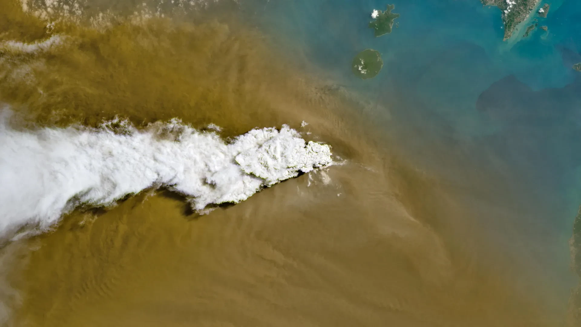
- At approximately mid-day, the OLI (Operational Land Imager) aboard the NASA-USGS Landsat 8 satellite captured crisp visual data revealing a brilliant white plume of volcanic gas towering above a much denser, darker brown cloud of heavy ash.
- Simultaneously, broader synoptic imagery from the Visible Infrared Imaging Radiometer Suite (VIIRS) aboard the Suomi NPP satellite mapped the lateral spread of the ejecta, illustrating how upper-level winds were catching the material and dispersing it across vast swaths of the maritime continent.
September 6: Peak Altitude and Regional Fallout
By the morning of September 6, the dimensions of the ash cloud became acutely clear to regional meteorological forecasters. Indonesia’s meteorological agency reported that the vertical extent of the plume had reached extraordinary heights. To the east of the volcano, ash had climbed to altitudes of roughly 6,000 meters (20,000 feet). More alarmingly, powerful westerly winds had propelled material toward the west, pushing ash clouds to staggering altitudes of up to 15,000 meters (50,000 feet).
This vertical distribution meant that the jet stream and high-altitude winds were carrying volcanic debris directly into major commercial aviation corridors. Concurrently, the Indonesian Humanitarian Coordination Platform (IHCP) issued its first flash updates as heavy ashfall began raining down on populated districts in West Java and the outskirts of the national capital, Jakarta.
September 7–8: Weakening Activity and Recovery
By September 6, the sustained, high-intensity explosive momentum of the eruption began to wane. The continuous roar and fountain-like discharge subsided, with Anak Krakatau transitioning back toward a more conventional Strombolian eruption pattern. This phase involved periodic, discrete bursts of ash and incandescent material rather than a continuous, choking column.
By September 8, safety assessments allowed for the gradual resumption of operations at key regional airports. Nevertheless, despite the easing of the immediate meteorological emergency, Indonesian authorities kept the volcano firmly at the second-highest alert level, recognizing that Anak Krakatau’s underlying magma conduit remained highly active and capable of renewing its fury at a moment’s notice.
Supporting Data
The scale of the Anak Krakatau eruption can be rigorously quantified through the metrics provided by satellite telemetry, meteorological observations, and logistical reports compiled during the crisis.
| Metric Category | Specific Data Point | Source / Context |
|---|---|---|
| Duration of Explosive Phase | > 24 hours of continuous activity | Early September 2026 eruptive surge |
| Plume Altitude (East) | Up to 6,000 meters (20,000 feet) | Indonesian Meteorological Agency (September 6) |
| Plume Altitude (West) | Up to 15,000 meters (50,000 feet) | Indonesian Meteorological Agency (September 6) |
| Airports Closed | 8 major hubs across Java and Sumatra | BMKG emergency directive |
| Flight Disruptions | Nearly 3,000 flights impacted | Regional aviation tracking reports |
| Volcano Alert Status | Second-highest tier (Maintained since July 2026) | Indonesian Volcanological Survey |
| Satellite Instruments Utilized | Landsat 8 (OLI) & Suomi NPP (VIIRS) | NASA / USGS Earth Observing System |
Remote Sensing Observations
The integration of orbital assets provided scientists with unprecedented real-time data regarding the composition and trajectory of the plume. The OLI instrument on Landsat 8 distinguished between sulfur dioxide-rich gas components and pulverized silicate ash particles based on spectral signatures. Meanwhile, the VIIRS sensor on Suomi NPP—part of the NASA EOSDIS LANCE and GIBS/Worldview networks—offered wide-area tactical maps that allowed disaster response teams to track the exact geographic footprint of the drifting ash canopy over the Java Sea and Indian Ocean.
Official Responses
Governments, disaster management agencies, and international bodies mobilized swiftly in the wake of the September 5 eruption to mitigate risks to human life, manage national transportation networks, and provide public health guidance.
Aviation Authorities and Airport Closures
Recognizing the catastrophic threat that microscopic volcanic glass poses to modern turbine engines—capable of melting inside combustion chambers and instantly crippling aircraft systems—the Indonesian Ministry of Transportation, in coordination with meteorological offices (BMKG), ordered the immediate closure of eight strategic airports across Java and Sumatra.
Airlines scrambled to cancel, divert, or delay nearly 3,000 domestic and international flights. Passengers stranded in terminals across Jakarta and surrounding cities faced days of logistical gridlock. However, aviation authorities defended the aggressive closures as a necessary precaution to prevent potential mid-air disasters. Following sustained cleanup operations and satellite confirmation that primary airlanes were clearing, restricted flight operations officially resumed on September 8.
Humanitarian and Health Interventions
The Indonesian Humanitarian Coordination Platform (IHCP) stepped into the crisis immediately, issuing flash updates to inform local populations of the impending ashfall. Civil defense units distributed millions of protective face masks across West Java and Jakarta, urging residents—particularly children, the elderly, and those with pre-existing cardiovascular or respiratory conditions—to remain indoors and seal ventilation points in their homes.
Public health officials also had to navigate a complex communications challenge. At the time of the eruption, parts of Indonesia were already grappling with the environmental health hazards of smoke produced by regional peatland fires. Government agencies took pains to educate the public on the distinct properties of the two atmospheric pollutants. While peatland smoke consists largely of fine organic carbon particulate matter and combustion gases requiring defense against organic toxins, volcanic ash is composed of abrasive, jagged silicate rock and glass particles that can cause severe mechanical irritation to the eyes, skin, and upper respiratory tract, necessitating distinct protective protocols and filtration media.
Implications
The explosive awakening of Anak Krakatau carries profound long-term implications for Indonesia’s disaster resilience, economic stability, and scientific understanding of arc volcanism.
Economic and Logistical Vulnerability
The sudden grounding of nearly 3,000 flights underscores the extreme vulnerability of modern Southeast Asian transportation networks to geophysical hazards. Indonesia is an archipelago nation heavily reliant on domestic aviation for commerce, governance, and emergency response. An event that can simultaneously paralyze eight major airports within a 48-hour window highlights the urgent need for more resilient aviation rerouting protocols, advanced real-time ash-tracking sensors, and reinforced infrastructure capable of withstanding heavy mineral fallout.
Public Health and Environmental Management
The concurrent assault of volcanic ash and wildfire smoke in late 2026 serves as a sobering warning regarding multi-hazard compounding events in the Anthropocene. As climate change increases the frequency of severe peatland and forest fires in the region, the intersection of meteorological extremes with geological hazards like volcanic eruptions presents a novel stress test for municipal health systems. Healthcare infrastructure in expanding urban centers like Jakarta must continually adapt to handle acute, multi-source respiratory crises.
Ongoing Volcanological Vigilance
Finally, the persistence of the second-highest alert level at Anak Krakatau—a status it has retained since July 2026—reminds the global scientific community that this geological feature is perpetually evolving. Born from the caldera of the legendary 1883 Krakatoa disaster, Anak Krakatau ("Child of Krakatoa") continues to build and destroy its own landmass through cyclic explosions and collapses.
For volcanologists, the 2026 event provides a wealth of empirical data on Strombolian-to-vulcanian transitions, plume dynamics, and satellite-based early warning integration. For the millions of citizens living along the coastlines of the Sunda Strait, however, the smoking cone remains an ever-present, majestic, and perilous neighbor—a perpetual symbol of the dynamic and volatile forces operating deep beneath the Earth’s crust.
