

SOUTHAMPTON, UK — For generations, humanity has gazed into the yawning, labyrinthine depths of the Grand Canyon, marveling at the relentless power of the Colorado River, which carved through layers of colorful rock to expose an astonishing archive of Earth’s history. Yet, according to a groundbreaking international study, the iconic canyon’s deepest secrets owe their exposure not to the river, but to a titanic, long-vanished geological feature that predates the modern landscape by nearly a billion years.
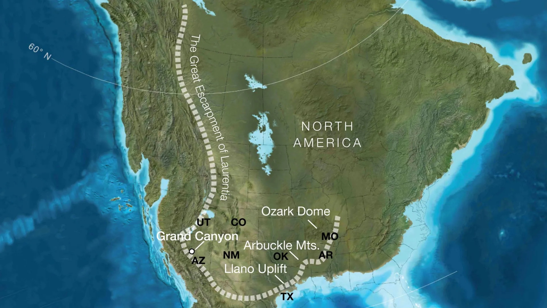
Led by a team of geoscientists at the University of Southampton, new research reveals that an enormous ancient cliff system—a colossal "great escarpment"—towered over western North America approximately 800 million years ago. Rising nearly a kilometer high and stretching across thousands of miles, this prehistoric precipice was born during the protracted, violent breakup of the ancient supercontinent Rodinia.
Over tens of millions of years, aggressive weathering and erosion along this massive rocky boundary stripped away miles of overlying material. This geological peeling process laid bare the ancient crystalline basement rocks that now form the bedrock of the Grand Canyon in southern Arizona, upending long-held assumptions about how the region evolved and offering a compelling new piece in one of geology’s most enduring puzzles: the mystery of the Great Unconformity.
Main Facts: Unveiling the Megastructure
The study, published in the prestigious journal Geology, brings together researchers from the University of Southampton, the GFZ Helmholtz Centre for Geosciences and the University of Potsdam in Germany, and the University of Illinois Urbana-Champaign in the United States.
At the core of their findings is the reconstruction of a prehistoric landscape that defies modern proportions. The researchers propose that an immense tectonic escarpment once cut a jagged path across regions that today encompass Arizona, Utah, Idaho, Wyoming, Colorado, Texas, Oklahoma, Arkansas, Missouri, and Illinois.
Key pillars of the discovery include:
- Towering Proportions: The ancient escarpment reached estimated heights of roughly one kilometer (0.6 miles) and extended continuously for thousands of kilometers along the margins of ancient North America (known to geologists as Laurentia).
- Massive Erosion: As the supercontinent Rodinia fragmented, tectonic uplift combined with intense surface processes to strip away an estimated five to ten kilometers of rock in various locations across the region.
- The Pre-River Origin: This colossal cliff system predates the modern Colorado River’s excavation of the Grand Canyon by nearly a billion years, acting as the primary mechanism that first brought deep-seated basement rocks close to the surface.
- Resolving a Continental Mystery: The landscape model directly aligns with physical evidence regarding the Great Unconformity—a globally recognized, deeply enigmatic gap in the geological record where miles of strata are inexplicably missing.
Chronology: A Billion-Year Journey Through Time
To understand the scale of this discovery, geologists must grapple with a frustrating reality: the Grand Canyon preserves a geological history stretching back roughly two billion years, yet more than half of that rock record appears to be missing. This temporal void is the heart of the Great Unconformity, a profound geological boundary where Cambrian-era strata rest directly upon much older, highly eroded crystalline rocks.
The newly published research charts a chronological pathway for how this gap was engineered across deep time:
Phase 1: The Fragmentation of Rodinia (~800 Million Years Ago)
Before the assembly of Pangea, earlier supercontinents dominated Earth’s geography. Around 800 million years ago, Rodinia began to tear apart. As tectonic plates pulled away from one another, the continental crust underwent profound thermal stretching and uplift. This rifting created steep, elevated topography along the continental margins—the birth of the great escarpment.
Phase 2: Inland Migration and Mass Denudation (750–500 Million Years Ago)
Once established, the towering cliff system acted as a topographic barrier. Over tens of millions of years, continuous erosion caused the giant escarpment to systematically retreat inland. As the cliffs migrated, they shed colossal volumes of sediment into surrounding basins. This relentless denudation planed down the surface of the continent, shearing away up to eight kilometers of rock in some sectors and unearthing the ancient basement complex that had formed deep within the Earth’s crust.
Phase 3: The Cryptic Era and the Cambrian Explosion (~541 Million Years Ago)
The mountainous rim around western Laurentia profoundly influenced surface environments, shaping regional river networks, controlling sediment distribution, and dictating marine transgression patterns as shallow seas advanced across the continent. This set the stage for the Cambrian explosion—a pivotal evolutionary epoch characterized by the sudden diversification of complex, multi-cellular life.
Phase 4: The Modern Interlude (Last 6 Million Years)
Long after the ancient escarpment had been worn down to a subdued landscape, the modern geological stage was set. Only within the last six million years did the Colorado River begin its youthful work, cutting through the pre-conditioned, shallowly buried basement rocks to carve the breathtaking labyrinth we recognize today as the Grand Canyon.
Supporting Data: Reconstructing Lost Landscapes
Recreating a landscape that vanished hundreds of millions of years ago requires an interdisciplinary toolkit. The research team combined state-of-the-art plate tectonic reconstructions with sophisticated numerical models of landscape evolution.
By analyzing how modern escarpments degrade under varying climatic and tectonic regimes, the scientists could model the behavioral mechanics of ancient continental margins. Their simulations revealed a striking modern analog: when Rodinia fragmented, the geographic position of the future Grand Canyon relative to the continental edge was remarkably similar to major escarpments observed today in South Africa and Brazil.
Furthermore, the team’s predictive models matched independent geological datasets showing that five to ten kilometers of rock had mysteriously vanished from the southwestern United States long before the Colorado River ever touched the plateau. By demonstrating that tectonic uplift related to continental rifting naturally generates both high ground and steep, rapidly eroding slopes, the study provides a robust physical mechanism for a phenomenon that has baffled geologists for generations.
Official Responses and Expert Insights
Professor Thomas Gernon of the University of Southampton, lead author of the study, emphasized the transformative nature of the findings.
"Our paper suggests the Canyon’s basement rocks were progressively brought to the surface as part of an immense escarpment that developed during the breakup of an ancient supercontinent," Professor Gernon explained. "The findings also shed light on the formation of the Great Unconformity, a mysterious gap in the rock record that spans over a billion years."
Addressing the broader geographic footprint of the ancient cliff system, Gernon noted how the research bridges local observations with global tectonic processes: "This long-lived tectonic landscape provides a missing piece in understanding why erosion associated with the Great Unconformity varies so dramatically across the southwestern US. Our work suggests that tectonic uplift related to continental rifting and breakup created both steep slopes and high ground, providing the mountainous terrain that rivers and glaciers could readily erode."
Co-investigators and international partners underscored the value of looking beyond North America to decode its past. By drawing direct comparisons with active continental margins in the Southern Hemisphere, the research team demonstrated how global geomorphology operates across vast stretches of time.
"Today’s escarpments in Africa, Brazil, India, and Antarctica provide windows into the forces that shape continents over hundreds of millions of years," Professor Gernon added. "By comparing the Grand Canyon’s ancient history with active landscapes like the Great Escarpment of South Africa, we’re able to see North America’s most iconic geologic landmark in an entirely new light."
Implications: Rewriting the Geological Textbook
The identification of this ancient megastructure carries profound implications that extend far beyond the borders of Arizona.
For decades, geologists have debated the precise drivers behind the Great Unconformity, proposing various hypotheses ranging from global glaciation ("Snowball Earth" events) to sweeping tectonic stripping. By demonstrating that localized, long-lived rift escarpments could drive massive, targeted continental denudation, this study offers a unified framework that reconciles localized variations in the geological record.
Moreover, the research provides geologists with a powerful new diagnostic tool. Many continental interiors around the globe feature similarly vast, unexplained gaps in their stratigraphic records. Armed with the Southampton team’s models of escarpment migration and rifting-induced erosion, researchers can now revisit these cryptic regions with a renewed perspective.
Ultimately, the study serves as a humbling reminder of Earth’s dynamic nature. The Grand Canyon—an icon of stability, permanence, and deep time—is revealed to be the product of multiple, sequential chapters of planetary upheaval. Long before water began carving stone in the American Southwest, titanic forces of supercontinental breakup forged a landscape of impossible scale, laying the foundations for one of the natural wonders of the modern world.
