

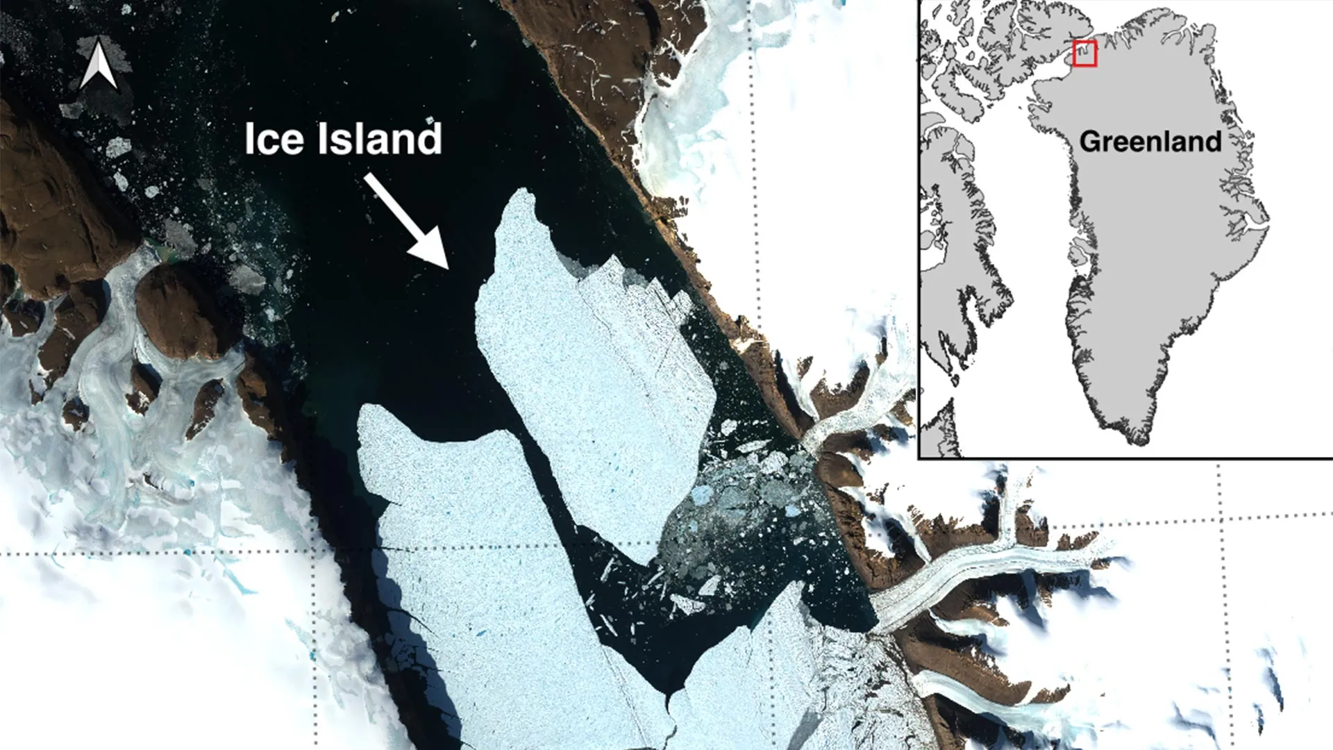
OTTAWA, ONTARIO — In a dramatic development that underscores the accelerating pace of polar transformation, an international team of researchers has documented a colossal calving event at the Petermann Glacier in northwest Greenland. On August 4, 2026, the glacier shed a massive tabular iceberg measuring 76.4 square kilometers—an expanse roughly equivalent in surface area to the island of Manhattan.
This monumental fracture marks the largest loss of floating ice from the Petermann Glacier since 2012 and stands as the single biggest Arctic calving event recorded since 2020. The newly formed ice island, plunging an estimated 150 meters deep into the Arctic Ocean, broke away from the glacier’s vulnerable floating ice tongue.
Spearheaded by the University of Ottawa (uOttawa) in collaboration with a distinguished consortium of international institutions—including the University of Stirling, Environment and Climate Change Canada (ECCC), Lancaster University, and the University of Leeds—the discovery offers glaciologists a rare, high-resolution view of how immense Arctic ice masses fracture, evolve, and drift through increasingly vulnerable polar waters.
Chronology of a Collapse: From Years of Fracturing to Sudden Separation
The journey toward this historic calving event has been meticulously tracked by scientists using long-term satellite observations dating back to 2019. Over a span of seven years, researchers closely monitored the health and structural integrity of the Petermann Glacier’s floating ice tongue, watching anxiously as a network of fractures steadily widened across the ice shelf.
The breakthrough identification of the August 4 break was made by Adam Garbo, a PhD student in glaciology within uOttawa’s Department of Geography, Environment and Geomatics.
"Petermann Glacier has long been one of Greenland’s largest remaining ice tongues," Garbo noted, reflecting on the years of buildup. "We’ve anticipated this break for years, and seeing it finally happen is remarkable."
The final sequence of the collapse unfolded rapidly over a 24-hour window, captured in stunning detail by radar imagery from the European Space Agency’s Sentinel-1 mission:
- August 3, 2026: Sentinel-1 satellites capture undeniable indicators of severe structural deterioration along the central axis of the Petermann ice tongue, signaling that the existing rifts had nearly compromised the remaining structural bridges.
- August 4, 2026 (20:00 UTC): The terminal tipping point is reached. The 76.4-square-kilometer tabular iceberg fully detaches from the eastern side of the glacier, officially becoming a free-floating ice island.
Despite the suddenness of the final separation, glaciologists emphasize that the event is the culmination of long-term thermal and mechanical stresses acting upon the glacier’s underbelly and surface.
Supporting Data: Dimensions, Projections, and a Shrinking Ice Tongue
To contextualize the scale of the August 4 event, researchers have analyzed the physical dimensions and future trajectory of the Petermann ice tongue using advanced remote-sensing datasets.
The newly liberated ice island is a classic tabular iceberg: flat-topped, sheer-sided, and staggering in volume. Descending up to 150 meters below the ocean surface, its sheer bulk dictates that ocean currents, rather than surface winds, will primarily drive its initial migration.
However, glaciologists warn that this event is merely a chapter in a much larger, ongoing reduction of the glacier. Active monitoring reveals that two additional massive sections of the floating ice tongue are under severe mechanical stress and are projected to detach in the near future.
Future Calving Projections:
- Impending Section Alpha: Estimated at approximately 94 square kilometers.
- Impending Section Beta: Estimated at approximately 84 square kilometers.
Should both of these sections break away as anticipated, the cumulative impact of the three events will strip roughly 254 square kilometers from the Petermann Glacier’s ice tongue. This successive loss will shrink the total area of the floating tongue by an alarming 22 percent, fundamentally altering the geometry and buttressing capacity of one of Greenland’s premier glacial outlets.
Furthermore, while massive tabular icebergs are a frequent and almost routine occurrence in the turbulent Southern Ocean surrounding the Antarctic Ice Sheet, they remain exceptionally rare in the Arctic. This rarity elevates the scientific value of the Petermann event.
Dr. Anna Crawford of the University of Stirling emphasized the broader cryospheric significance of the phenomenon: "While large, tabular icebergs are relatively common in the Southern Ocean that surrounds the Antarctic Ice Sheet, Arctic ice islands are far rarer. By studying Arctic ice islands, we will gain knowledge that can be transferred across polar regions, helping us better understand the shared mechanics of ice shelf disintegration in a warming world."
Official Responses and Collaborative Science
The magnitude of the Petermann calving event has elicited coordinated responses from academic institutions and governmental agencies alike. The discovery is the direct product of a robust, multi-agency research network designed to bridge theoretical glaciology with operational environmental monitoring.
Adam Garbo’s foundational detection highlights the critical role of emerging researchers in modern Earth sciences, operating under the guidance of a seasoned international coalition. The research team combines uOttawa’s cryospheric expertise with the ecological and meteorological tracking capabilities of Environment and Climate Change Canada, alongside the glaciological modeling prowess of Lancaster University, the University of Leeds, and the University of Stirling.
Government bodies are wasting no time in assessing the operational realities born from the ice shelf’s collapse. With the ice island now adrift, national and international science divisions are pivoting from purely observational studies to hazard mitigation and tracking protocols.
The collaborative framework ensures that high-resolution satellite data, aerial reconnaissance, and in-situ buoy tracking are shared seamlessly among all participating entities. This ensures that academic inquiry directly supports public safety and environmental oversight in the high latitudes.
Implications: Polar Change, Shipping Hazards, and Marine Safety
While the physical detachment of a Manhattan-sized ice block is a momentous scientific milestone, the broader implications of the event extend far beyond academic journals. The birth of this ice island presents tangible, long-term challenges for Arctic geopolitics, marine navigation, and commercial maritime operations.
Navigational Risks to Arctic Shipping
As the Arctic sea ice continues to experience seasonal declines, international shipping companies, commercial fishing fleets, and resource extraction vessels increasingly eye northern transit routes like the Northwest Passage. However, the introduction of massive ice islands radically increases navigational unpredictability.
Dr. Abigail Dalton of the Canadian Ice Service, speaking on behalf of Environment and Climate Change Canada, outlined the operational dangers posed by the newly freed ice: "These are thick blocks of ice that can drift for years. Over time, they fracture into smaller, harder-to-track pieces that pose significant hazards to vessels and resource operations."
Because these ice islands are up to 150 meters thick, deep ocean currents propel them independently of surface winds and surrounding sea ice. They can stubbornly persist for years, surviving transport into warmer waters before they finally disintegrate. As they crack down into smaller, weathered bergs and growlers, they become notoriously difficult for ship radar and automated identification systems to detect, creating invisible hazards for maritime traffic.
A Window Into Systemic Climate Shifts
For the scientific community, the Petermann event serves as an unvarnished barometer of changing polar conditions. The rapid progression of rifts, combined with warming ocean waters eating away at the undersides of Greenland’s floating ice tongues, points toward a systemic destabilization of the region’s marine-terminating glaciers.
Garbo, alongside his international collaborators, intends to maintain an unbroken watch on the Petermann Glacier and its drifting offspring. Utilizing a combination of high-frequency satellite imagery, targeted aerial surveys, and oceanographic tracking data, the team aims to decode the complex feedback loops driving the accelerated retreat of Arctic ice shelves.
As the Manhattan-sized ice island begins its slow, perilous drift out of the Petermann Fjord and into the broader Arctic channels, it carries with it a stark message: the high northern latitudes are undergoing a profound transformation, and the ripple effects of this collapse will be felt across ocean ecosystems and shipping lanes for years to come.
