

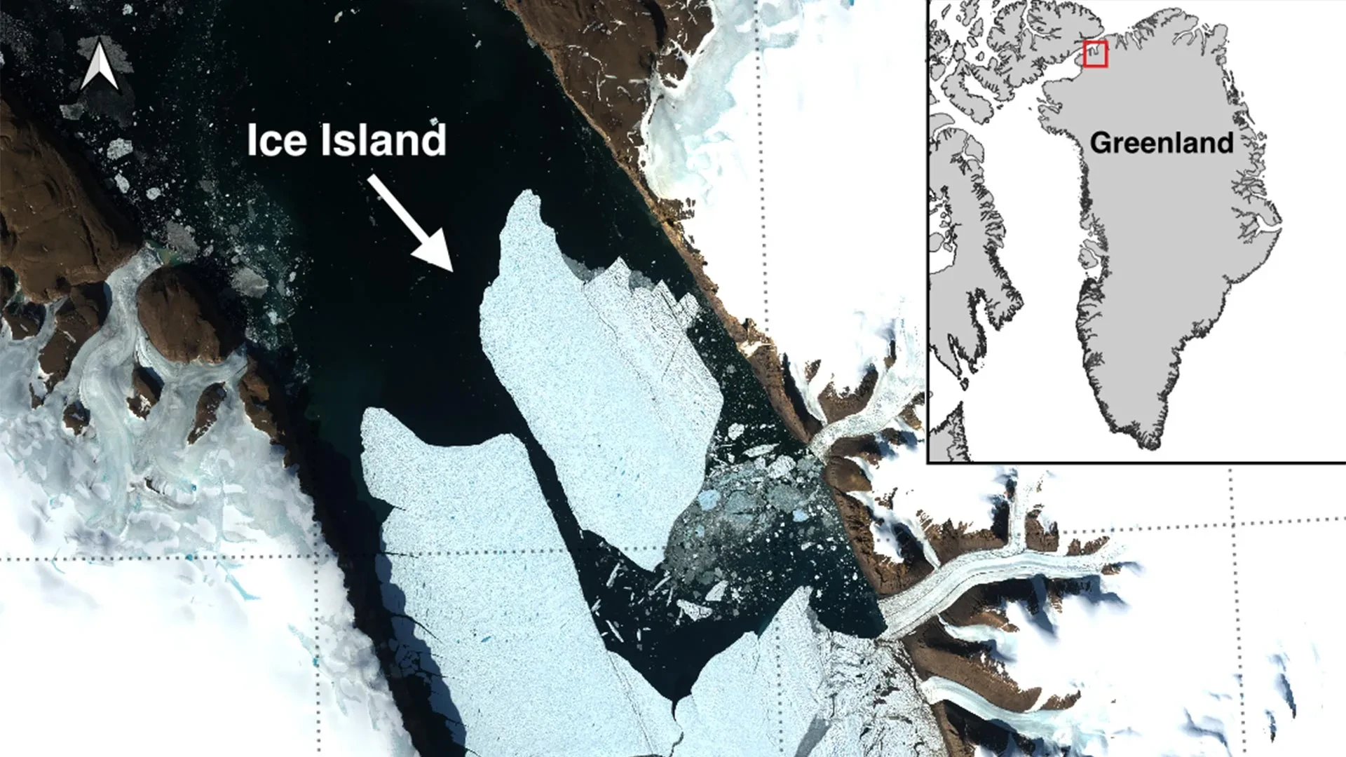
OTTAWA, CANADA / NORTHWEST GREENLAND — In a dramatic demonstration of the rapid transformations reshaping the Earth’s cryosphere, an international coalition of glaciologists has documented a monumental calving event at the Petermann Glacier in northwest Greenland. On August 4, 2026, the glacier abruptly released a colossal, flat-topped ice island measuring 76.4 square kilometers—an area roughly equivalent to the island of Manhattan.
This historic fracture marks the single largest loss of floating ice from the Petermann Glacier since 2012 and stands as the most significant Arctic calving event recorded since 2020. The newly formed tabular iceberg, estimated to be up to 150 meters thick, broke away from the glacier’s vulnerable floating ice tongue, injecting an immense volume of freshwater ice into the freezing waters of the Nares Strait.
The event has triggered an immediate mobilization of the international scientific community, offering researchers a rare, high-resolution window into the dynamics of Arctic ice sheet destabilization. Led in part by the University of Ottawa (uOttawa), the research initiative unites experts from the University of Stirling, Environment and Climate Change Canada (ECCC), Lancaster University, and the University of Leeds. While the immediate focus remains on tracking the trajectory of the newly birthed megaberg, scientists warn that this event is merely a precursor to deeper, more structural losses anticipated for one of Greenland’s last remaining major ice tongues.
Main Facts: Anatomy of a Colossus
To understand the magnitude of the August 4 event, researchers must look closely at the physical dimensions and structural nature of the ice that departed the Greenlandic coast.
The newly liberated tabular iceberg is not a standard, jagged-peaked berg. Instead, it is a classic "ice island"—a flat, table-like mass of glacier ice that formed as an extension of the land-based ice sheet before floating out over the ocean water while remaining attached at its grounding line. Spanning 76.4 square kilometers and plunging up to 150 meters deep into the water column, the block represents a staggering mass of compacted ancient snow and ice.
- Date of Separation: August 4, 2026 (fully separated by 20:00 UTC).
- Surface Area: 76.4 km² (comparable to Manhattan Island).
- Estimated Thickness: Up to 150 meters.
- Geographic Location: Petermann Glacier, Northwest Greenland (Nares Strait).
- Historical Context: Largest loss of floating ice from Petermann since 2012; largest Arctic calving event since 2020.
- Institutional Leadership: University of Ottawa, in collaboration with the University of Stirling, Environment and Climate Change Canada, Lancaster University, and the University of Leeds.
While tabular icebergs of this scale are a routine fixture of the Southern Ocean surrounding Antarctica, where massive ice shelves regularly calve similar structures, they are exceptionally rare in the Arctic. Their relative scarcity in the Northern Hemisphere makes the Petermann event a prized, albeit alarming, natural laboratory for polar researchers.
Chronology of a Fracture: From Satellite Watch to Sudden Rupture
The discovery of the calving event was made by Adam Garbo, a PhD student specializing in glaciology within uOttawa’s Department of Geography, Environment and Geomatics. However, the event itself was the climax of a years-long detective story played out across computer screens and satellite feeds.
The Years of Growing Instability (2019–2025)
Scientists have maintained a vigilant, long-term satellite surveillance program over the Petermann Glacier since 2019. Over this multi-year window, glaciologists closely monitored the structural integrity of the glacier’s floating ice tongue, mapping the slow, relentless expansion of deep transverse fractures and rifts. These fissures acted like ticking clocks, cutting laterally across the ice tongue and signaling to researchers that a catastrophic structural failure was not a matter of if, but when.
"Petermann Glacier has long been one of Greenland’s largest remaining ice tongues," reflects Adam Garbo, who first identified the August 4 break. "We’ve anticipated this break for years, and seeing it finally happen is remarkable. It validates the predictive power of our monitoring networks, but it also underscores the relentless pressures acting on these polar systems."
The Final Hours: August 3–4, 2026
The final sequence of the breakup was captured in high-definition detail by the European Space Agency’s Sentinel-1 radar imaging mission, which can pierce through Arctic cloud cover and darkness.
- August 3, 2026: Sentinel-1 imagery revealed definitive, accelerated signs of structural deterioration along the centerline of the Petermann ice tongue. Stress points that had remained stable for months began to yield, widening at an exponential rate.
- August 4, 2026 (20:00 UTC): The terminal threshold was breached. The immense tensile stresses overcame the remaining lateral pinning points on the eastern side of the glacier, causing a clean, echoing fracture. Within hours, the 76.4 km² ice island had fully separated from the main body of the ice tongue, pivoting slightly as it met the open waters of the fjord.
Supporting Data: The Looming Threat of Cascading Calvings
If the August 4 calving event is striking on its own, it is even more concerning when viewed as part of a broader, cascading sequence of instability. Glaciologists analyzing the telemetry data from Petermann emphasize that the system has not stabilized following the departure of the new ice island.
Future Projections
Rifts that have been chewing through the remaining portions of the floating ice tongue for years continue to propagate. Based on current satellite measurements and fracture mapping, researchers have identified two additional massive sections poised to detach in the near future:
- Future Section Alpha: Projected to measure approximately 94 km².
- Future Section Beta: Projected to measure approximately 84 km².
Cumulative Impact on the Petermann Ice Tongue
The arithmetic of these impending detachments paints a sobering picture of the glacier’s immediate future. If both anticipated sections break away in the coming months or years, the combined impact of the three calving events (including the August 4 loss) will strip approximately 254 square kilometers of ice from the Petermann ice tongue.
This cumulative loss will reduce the total surface area of the floating tongue by an estimated 22 percent. While the floating ice tongue does not directly raise global sea levels when it calves—since it is already afloat—its reduction weakens the structural "buttressing" effect that can ultimately influence the flow speed of grounded glaciers upstream.
Official Responses and Scientific Perspectives
The international scientific community has responded to the Petermann event with a blend of academic fascination and urgent environmental concern. The collaborative framework underpinning the research highlights the borderless nature of polar science.
Dr. Anna Crawford of the University of Stirling, a co-investigator on the project, emphasizes the unique scientific value of the event. "While large, tabular icebergs are relatively common in the Southern Ocean that surrounds the Antarctic Ice Sheet, Arctic ice islands are far rarer," Dr. Crawford notes. "By studying Arctic ice islands, we will gain knowledge that can be transferred across polar regions, helping us untangle how shifting ocean temperatures and atmospheric forcing conspire to break up Earth’s northernmost ice shelves."
The research team—spanning uOttawa, Stirling, Lancaster, Leeds, and Canadian federal agencies—stresses that understanding the mechanics of these shelf retreats is vital for refining global sea-level rise projections. As Arctic temperatures continue to warm at rates double the global average, the structural integrity of Greenland’s remaining northern ice shelves is increasingly compromised by both atmospheric melting (surface melt ponds draining into crevasses) and oceanic melting from below, where warm subsurface currents erode the bases of floating ice tongues.
Implications: Navigational Hazards and Arctic Marine Safety
Beyond the realm of climate science and glaciology, the birth of a 76.4-square-kilometer ice island carries immediate, tangible consequences for commercial activities in the high north.
Massive tabular icebergs of this scale are notoriously durable. Because of their immense thickness—up to 150 meters—they possess deep drafts, meaning a significant portion of their mass extends far below the ocean surface, where deep-water currents can drive them along unpredictable trajectories independent of surface winds. These ice islands can remain structurally intact for years as they drift out of fjords and into open Arctic shipping lanes, gradually fracturing over time into smaller, highly hazardous subsidiary bergs and "growlers."
Recognizing these risks, Environment and Climate Change Canada (ECCC)—through the Canadian Ice Service—has activated enhanced tracking protocols, continuing a long-standing mandate of monitoring major Arctic ice shelf calving events.
"These are thick blocks of ice that can drift for years," warns Dr. Abigail Dalton of the Canadian Ice Service, ECCC. "Over time, they inevitably fracture into smaller, harder-to-track pieces that pose severe, latent hazards to commercial vessels, fishing fleets, and offshore resource operations navigating northern waters."
As the newly formed ice island begins its slow, formidable journey away from the northwest coast of Greenland, it will be doggedly shadowed by satellite telemetry, aerial reconnaissance, and oceanographic tracking. For Adam Garbo and his collaborators at the University of Ottawa and partner institutions, the work has only just begun. Their ongoing observations will feed directly into international databases aimed at safeguarding Arctic maritime corridors and decoding the rapidly shifting dynamics of a warming planet.
