

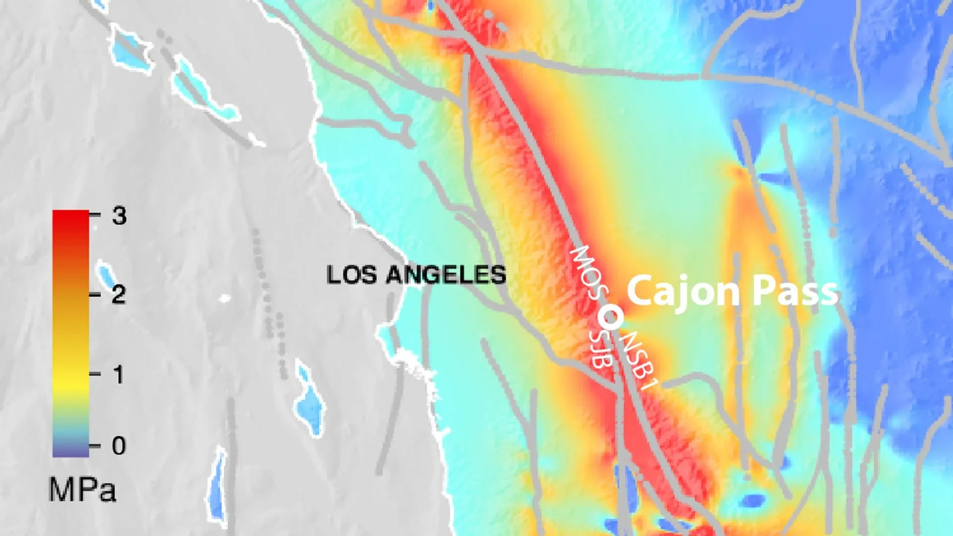
LOS ANGELES — Beneath the sprawling expanse of Southern California, a silent, subterranean engine has been tightening its grip for more than a century and a half. According to groundbreaking new research published in the Journal of Geophysical Research: Solid Earth, tectonic stress along two of the region’s most formidable fault networks has reached—and in some areas surpassed—the highest levels recorded in a simulated 1,000-year history.
Led by Dr. Liliane Burkhard of the Division of Space Research and Planetary Sciences (WP) at the Physics Institute of the University of Bern, an international team of geoscientists has peered deep into the geologic past to better understand the volatile present. Collaborating with researchers from the University of Hawaiʻi at Mānoa, the U.S. Geological Survey (USGS) Earthquake Science Center in Pasadena, and the Scripps Institution of Oceanography at UC San Diego, Burkhard’s team utilized advanced four-dimensional modeling to reconstruct a millennium of seismic activity.
Their findings reveal a stark reality: the broader Los Angeles metropolitan area, which has largely avoided a catastrophic, region-wide seismic event since the mid-19th century, sits atop a critically overstressed fault architecture. While scientists stress that high stress does not equate to an immediate prediction, the newly mapped conditions heighten concerns regarding the potential for a sprawling, multi-fault rupture that could reshape disaster preparedness across the American Southwest.
Main Facts
At the heart of the new study are the San Andreas and San Jacinto faults—two giant tectonic arteries that accommodate the lion’s share of the Pacific and North American plate boundary motion in Southern California. Northeast of Los Angeles, these systems converge at the Cajon Pass, a complex geological junction that acts as a critical valve for seismic energy.
Using a physics-based, four-dimensional earthquake cycle model, the researchers tracked how stress accumulates during seismic quiet periods, how individual earthquakes redistribute stress to neighboring segments, and how the deep crust relaxes over centuries. The primary takeaways from the study include:
- Millennial Peak Stress: Modeled tectonic stress across key segments of the southern San Andreas and San Jacinto systems has reached historic highs, topping anything seen in the model’s 1,000-year historical reconstruction.
- The "Earthquake Gate" Phenomenon: The Cajon Pass functions as a dynamic junction. Depending on the concurrent stress states of both fault systems, the pass can either halt a propagating rupture or allow it to leap seamlessly from one fault system to the other, creating a massive, combined earthquake.
- Synchronized High Pressure: The model measures stress on the San Jacinto-Bernardino section at 3.6 megapascals (MPa)—higher than any value achieved in the 1,000-year simulation—while the Mojave South section of the San Andreas fault sits at 2.8 MPa. This synchronized elevation in stress closely mirrors conditions that preceded past multi-fault ruptures.
- Vast Vulnerability: A joint rupture involving both systems would affect a heavily populated, highly interdependent economic powerhouse, stretching from Greater Los Angeles through the Inland Empire and into the Coachella Valley.
Chronology of the Faults: From Historical Ruptures to Modern Modeling
To understand why the current stress levels are alarming geologists, one must look backward through the region’s seismic timeline.
Southern California’s fault networks operate on a cycle of friction, lock, and release. As the tectonic plates grind past one another, sections of the Earth’s crust become frictionally locked. Stress accumulates over decades or centuries until the frictional threshold is exceeded, resulting in sudden slippage—an earthquake.
The Greater Los Angeles region has experienced a prolonged seismic quiet period along its primary fault systems. The last comparable major earthquake to disrupt this specific network was the magnitude 7.9 Fort Tejon earthquake in 1857, which ruptured a massive stretch of the San Andreas Fault. However, historical records, tree-ring anomalies, and radiocarbon dating paint a more complex historical picture of how faults interact at junctions like the Cajon Pass:
- The 1812 Wrightwood Earthquake: Historical and geological data indicate that this event successfully breached the Cajon Pass "earthquake gate," triggering a through-going rupture that tore through both the San Andreas and San Jacinto fault systems simultaneously.
- The 1857 Fort Tejon Earthquake: In contrast, the great 1857 rupture traveled down the San Andreas fault but encountered the Cajon Pass under different stress conditions, halting at the junction without jumping to the San Jacinto fault.
- The 1868–Present Quiet Interlude: For over 165 years, the southern branches of these systems have largely refrained from releasing their accumulated strain through a major regional event. Instead, tectonic motion has continued unabated at depth, steadily packing energy into the locked crust.
- The Modern Simulation (2024 Study): By synthesizing 1,000 years of paleoseismic data into a 4D physics model, researchers were able to play back and forth through centuries of stress accumulation, ultimately outputting the unprecedented pressure readings observed in the current geological epoch.
Supporting Data: Decoding the Numbers Behind the Stress
Geoscience relies heavily on quantitative metrics to evaluate subterranean hazards. In this study, the research team utilized megapascals (MPa)—a standard unit of pressure or mechanical stress—to quantify the load bearing down on individual fault segments.
The model’s outputs provide a granular look at the mechanical forces at play:
- 3.6 MPa: The modeled stress level currently resting on the San Jacinto-Bernardino section. According to historical simulations, this value eclipses every maximum reached over the past 1,000 years for that specific segment.
- 2.8 MPa: The modeled stress level on the Mojave South section of the San Andreas fault.
- 1,000 Years: The temporal depth of the simulation, constructed by integrating radiocarbon-dated sediment layers, paleoseismic trenching data, historical accounts of surface ruptures, and dendrochronology (tree-ring stress signatures).
Dr. Burkhard notes that the absolute stress number on a single fault is only part of the puzzle. The true indicator of danger lies in the relative alignment of stress across adjacent systems. When both the San Andreas and San Jacinto faults approach critical thresholds concurrently, the mechanical barriers at junctions like the Cajon Pass effectively dissolve under the sheer weight of tectonic pressure. This configuration creates ideal conditions for a cascading, multi-fault rupture.
Official Responses and Scientific Consensus
The publication of the study in the Journal of Geophysical Research: Solid Earth has drawn widespread attention from the seismological community, emergency management agencies, and civil infrastructure planners.
Leading institutions, including the U.S. Geological Survey (USGS), have long emphasized that Southern California must remain vigilant against major seismic events. While the new model does not provide a calendar date for the next big earthquake, it fundamentally refines how scientists view the potential scale of a future disaster.
Speaking on the implications of the work, Dr. Burkhard was careful to manage public interpretation:
"The study is not a prediction of when an earthquake will occur. What we can say is that the system is critically stressed and that physics-based models like ours give a clearer picture of the range of scenarios we should be prepared for. This information is important for hazard assessment, infrastructure planning and emergency preparedness."
Emergency management officials across California have echoed these sentiments. Rather than triggering panic, studies of this caliber are utilized to stress-test regional disaster response plans, update building codes, and reinforce critical lifelines. The California Governor’s Office of Emergency Services (Cal OES) and local municipal agencies regularly incorporate advanced USGS and academic modeling into exercises aimed at preparing for worst-case urban disaster scenarios.
Furthermore, seismologists note that the framework developed by Burkhard and her colleagues is not geographically restricted to the Golden State. Complex fault junctions exist in active tectonic zones across the globe—from the Anatolian Fault in Turkey to the Alpine Fault in New Zealand. The methodology of coupling multi-century paleoseismic data with 4D physical models offers a new global standard for evaluating fault network interactions.
Implications: Preparing for the "Big One" and Beyond
The societal stakes of these geological findings cannot be overstated. Should the Cajon Pass gate fail during a future seismic event, the resulting dual-fault rupture would affect an immense geographic footprint encompassing millions of residents.
Public Safety and Demographics
The areas flanking the San Andreas and San Jacinto systems include some of the fastest-growing and most densely populated communities in the United States. Greater Los Angeles, San Bernardino, Riverside, and the sprawling expanse of the Coachella Valley house over 20 million people. A magnitude 8-class multi-fault rupture would generate severe, prolonged ground shaking across urban centers that feature a mix of modern earthquake-resistant high-rises and vulnerable legacy infrastructure.
Critical Infrastructure Corridors
Beyond residential populations, the Cajon Pass itself is a vital lifeline. It serves as a major geographical bottleneck for transportation and commerce, carrying:
- Interstate 15, the primary economic and commuter artery connecting Southern California to Las Vegas and the Intermountain West.
- Transcontinental freight and passenger rail lines linking West Coast ports to the rest of the nation.
- Essential energy infrastructure, including high-voltage electrical transmission lines, natural gas pipelines, and petroleum products feeding the Southland.
A major rupture through the pass could sever these lifelines simultaneously, isolating regions, paralyzing supply chains, and complicating emergency response and rescue operations in the immediate aftermath of a disaster.
Proactive Resilience
Ultimately, the Bern-led study transforms theoretical geology into actionable preparedness. By mapping out the physical plausibility of joint ruptures under historic stress highs, scientists are giving planners the data they need to reinforce bridges, upgrade water conveyance systems, retrofit older buildings, and refine early-warning frameworks like ShakeAlert.
As Southern California continues its quiet countdown beneath the San Andreas and San Jacinto shadows, the message from the scientific community is clear: while nature dictates the accumulation of tectonic stress, human ingenuity and preparedness will dictate how the region withstands its eventual release.
