

Introduction and Main Facts
In early September 2026, the Sunda Strait off the coast of Indonesia became the epicenter of a dramatic geological awakening. Anak Krakatau, a notoriously volatile volcanic cone nestled between the sprawling islands of Java and Sumatra, erupted in a powerful, sustained explosive phase that lasted for more than 24 hours. The cataclysmic event sent towering plumes of gas, rock, and ash tens of thousands of feet into the atmosphere, throwing regional transportation networks into chaos and severely degrading air quality across some of the most densely populated provinces in the country.
The eruption, which began in earnest during the first week of September, immediately disrupted thousands of commercial flights, forced the temporary closure of eight major regional airports, and coated communities across West Java and the capital city of Jakarta in a gritty layer of volcanic debris. While Anak Krakatau—whose name translates literally to "Child of Krakatoa"—is well-known for its frequent, relatively modest Strombolian eruptions, this episode quickly escalated into a severe hazard. Satellites orbiting hundreds of miles above the Earth captured the staggering scale of the event, broadcasting images of colossal white gas plumes juxtaposed against dense, dark brown ash clouds stretching across maritime Southeast Asia.
As aviation authorities scrambled to reroute planes and local governments issued urgent public health advisories, the eruption laid bare the perpetual vulnerability of modern infrastructure to the unpredictable fury of the Pacific Ring of Fire. By the time the volcano’s most aggressive phase subsided, the incident had affected millions of residents, grounded nearly 3,000 flights, and triggered a massive coordinated response from Indonesian disaster management agencies and international meteorological networks.
Chronology of the Event
The escalation of Anak Krakatau’s activity in September 2026 did not happen in a vacuum, but the suddenness of the primary explosive phase caught many by surprise. The volcano had already been operating under an elevated threat status since July 2026, maintaining the second-highest alert level on Indonesia’s national volcanic warning scale due to persistent, low-level unrest. However, the situation deteriorated rapidly in the opening days of September.
September 5, 2026: The Paroxysmal Outburst
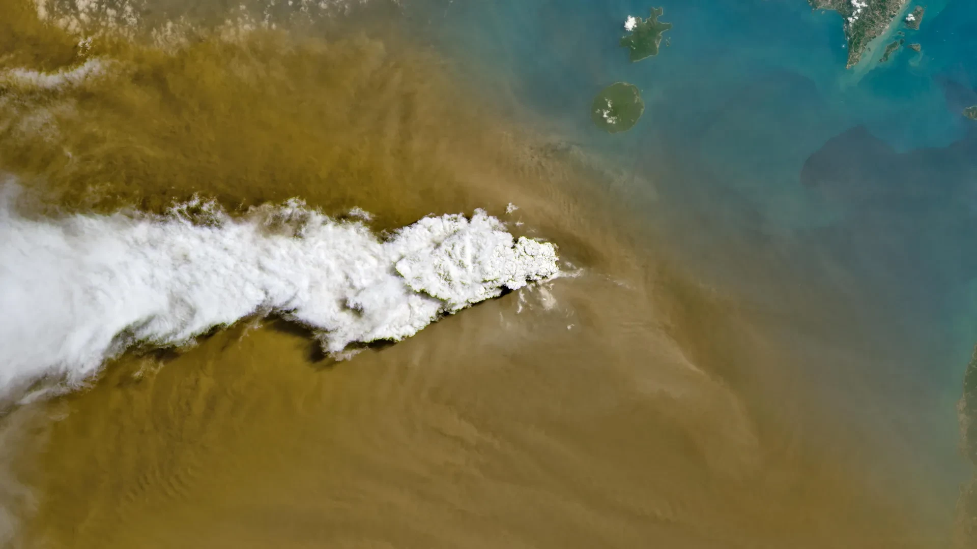
On September 5, Anak Krakatau entered a prolonged explosive phase. Within hours, continuous venting and explosions propelled vast quantities of pyroclastic material high into the troposphere. The eruption column was so massive that it was instantly logged by space-borne observation systems. Operational Land Imager (OLI) instruments aboard the NASA-USGS Landsat 8 satellite photographed the initial moments of the paroxysm, clearly showing brilliant white plumes of volcanic gas towering over heavy, dark brown ash clouds. Simultaneously, broader thermal and optical captures from the Visible Infrared Imaging Radiometer Suite (VIIRS) on the NASA/NOAA Suomi NPP satellite tracked the volcanic material as it began to disperse across a massive maritime footprint, blanketing parts of the Sunda Strait and drifting toward mainland Java.
September 6, 2026: Peak Atmospheric Dispersion and Ground Impact
By the morning of September 6, the scale of the atmospheric injection became fully apparent. Indonesia’s meteorological, climatological, and geophysical agency reported that ash plumes had reached extreme altitudes. Driven by upper-level wind patterns, ash climbed as high as 6,000 meters (20,000 feet) to the east over Java, while western plumes surged to an astonishing 15,000 meters (50,000 feet) toward Sumatra.
This high-altitude distribution created an immediate hazard for aviation. The sheer density and geographic spread of the ash cloud forced the closure of eight domestic and international airports across Java and Sumatra. On the ground, the Indonesian Humanitarian Coordination Platform (IHCP) issued its first flash updates as heavy ashfall began raining down on populated districts east of the volcano, including West Java and Jakarta. Compounding the crisis, the region was simultaneously battling concurrent peatland fires, creating a complex atmospheric hazard where volcanic debris mixed with wildfire haze.
September 7–8, 2026: De-escalation and Aviation Recovery
By September 6, the ferocious, continuous roar of the sustained explosive phase began to weaken, signaling a transition back to a more episodic pattern of behavior. While the volcano continued to rumble and periodically belch ash in classic Strombolian bursts, the continuous output diminished significantly.
Cleanup operations and atmospheric clearing allowed aviation authorities to reassess safety parameters. By September 8, airports that had been shuttered for days successfully resumed operations, allowing thousands of stranded passengers to finally reach their destinations. Despite the resumption of flights, however, Indonesian authorities maintained Anak Krakatau at its second-highest alert level, recognizing that the volcano remained dangerously unpredictable.
Supporting Data and Scientific Observations
The September 2026 eruption provided volcanologists, atmospheric scientists, and disaster management experts with a wealth of empirical data. The intersection of ground-based monitoring networks and space-based remote sensing offered unprecedented visibility into the dynamics of the eruption.
Satellite and Remote Sensing Insights
Earth-observing satellites played a critical role in tracking the hazard in real time. According to data processed by the NASA Earth Observatory—utilizing contributions from Michala Garrison, USGS Landsat data, and NASA EOSDIS LANCE, GIBS/Worldview, and Suomi NPP systems—the eruption’s footprint was categorized into distinct aerial layers.
- The Gas-Ash Dichotomy: Landsat 8’s OLI captured a stark visual distinction between the upper-level sulfur dioxide and water vapor gases (rendering a bright white plume) and the pulverized rock, glass, and mineral ash underneath (appearing as a heavy, brooding brown cloud).
- Wind Shear and Altitude Discrepancies: VIIRS data illustrated how regional wind shear acted upon the eruption column. The striking variance between the 6,000-meter eastward ash drift and the 15,000-meter westward drift demonstrated the complex layering of wind vectors in the upper atmosphere over Indonesia during the transition between seasonal monsoons.
Aviation Disruption Metrics
The logistical footprint of the disaster was staggering. The closure of eight strategic airports across the Sunda Strait corridor crippled regional mobility. According to global aviation trackers and local news reports, nearly 3,000 commercial flights—ranging from short-haul domestic hops between Jakarta and Sumatra to broader international routes traversing Indonesian airspace—were canceled, delayed, or heavily rerouted. Volcanic ash poses a catastrophic threat to jet aircraft; microscopic glass and rock particles can melt inside high-temperature jet turbines, fusing into a glass-like coating that causes engine failure, fouls fuel systems, and strips cockpit windshields of visibility.
Geological Context: The Legacy of Krakatoa
To understand the behavior of Anak Krakatau, scientists look to its infamous parent. The original Krakatoa volcano suffered a cataclysmic, world-altering collapse in 1883. In 1927, a new volcanic island—Anak Krakatau, or the "Child of Krakatoa"—emerged from the caldera left behind by the 1883 disaster. Growing incrementally through decades of frequent eruptions, Anak Krakatau experienced a catastrophic flank collapse in December 2018 that triggered a deadly tsunami along the coasts of Java and Sumatra. The 2026 explosive phase underscores that the modern cone remains highly dynamic, structurally fragile, and continuously supplied by a shallow, active magma reservoir beneath the Sunda Strait.
Official Responses and Public Health Management
The sudden eruption triggered a swift, multi-agency mobilization across Indonesia, balancing aviation safety, emergency logistics, and public health defense.
Aviation Authorities and Airspace Management
The Directorate General of Civil Aviation in Indonesia, working in lockstep with the country’s meteorological agency, implemented rapid-response protocols. When satellite data confirmed the trajectory of high-altitude ash plumes, flight paths were immediately cleared. Air Traffic Control (ATC) issued volcanic ash advisories (VAAs) that led to the preventive shutdown of eight regional airports. This proactive stance averted what could have been a catastrophic aviation accident, ensuring that no commercial airliners blundered into the dense, abrasive core of the ash cloud.
Humanitarian Coordination and Air Quality Management
On the ground, the Indonesian Humanitarian Coordination Platform (IHCP) stepped into a coordinating role, issuing flash updates and distributing safety directives to affected communities. The agency focused heavily on public health communications, warning residents across West Java and Jakarta about the risks of ash exposure.
Volcanic ash is chemically abrasive and composed of jagged micro-fragments of volcanic glass and minerals. Inhaling these particles can severely irritate the upper and lower respiratory tracts, triggering acute asthma attacks, bronchitis, and long-term pulmonary complications. Skin contact can cause severe dermatitis, and eye irritation is almost guaranteed for those caught outdoors without protective eyewear.
Furthermore, the IHCP highlighted a unique management challenge during the September 2026 event: the simultaneous occurrence of volcanic ashfall and heavy smoke from peatland fires elsewhere in the archipelago. Government health officials emphasized to the public that volcanic ash and wildfire smoke require distinct mitigation strategies. While wildfire smoke is predominantly composed of fine organic particulates and carbonaceous compounds manageable with standard particulate respirators (such as N95 masks), heavy volcanic ashfall poses greater structural, abrasive, and weight hazards—requiring eye protection, goggles, and measures to prevent the collapse of ash-laden roofs on vulnerable buildings.
Implications and Future Outlook
As the immediate crisis recedes and commercial flights resume normal schedules, the September 2026 eruption of Anak Krakatau leaves behind a series of critical implications for Indonesia and the broader global volcanology community.
Economic and Logistical Vulnerability
The paralysis of nearly 3,000 flights and the closure of key regional airports highlight the vulnerability of modern supply chains and tourism-dependent economies to natural hazards. Indonesia, an archipelago nation of over 17,000 islands, relies heavily on air transport to maintain economic cohesion between its major population centers. The event has reignited debates among aviation authorities and airline executives regarding the need for more advanced, real-time laser-based ash detection systems (such as airborne LIDAR) to allow for more nuanced, corridor-specific airspace management rather than broad, multi-airport shutdowns.
Ongoing Volcanic Monitoring and Preparedness
With Anak Krakatau maintaining its second-highest alert level—a status unbroken since July 2026—scientists from the Center for Volcanology and Geological Hazard Mitigation (PVMBG) maintain round-the-clock surveillance. The volcano’s shift from continuous explosion to intermittent Strombolian activity does not mean the danger has passed; rather, it indicates that the system remains pressurized and capable of sudden reactivation.
The 2026 eruption serves as a stark reminder of the relentless geological forces shaping the Indonesian archipelago. As populations continue to grow in the shadow of the Sunda Strait’s most famous restless giant, the integration of advanced satellite remote sensing, ground-based seismic sensors, and rapid humanitarian communication remains the first and best line of defense against the unpredictable fury of Anak Krakatau.
