

PAPUA NEW GUINEA — Oceanographers frequently note a humbling paradox of modern exploration: humanity has mapped the surfaces of the Moon and Mars in far greater detail than the mysterious, crushing depths of Earth’s own oceans. This contrast is nowhere more striking than in the Bismarck Sea, located north of Papua New Guinea. Here, a labyrinth of tectonic faults, volcanic structures, rifts, scarps, and active subduction and spreading zones lies hidden beneath thousands of meters of water. Because of these extreme depths and geographic isolation, the seafloor remains profoundly under-explored.
That enduring veil of marine obscurity was dramatically pierced on May 8, 2026. On this day, a suite of global orbital instruments detected the unmistakable signatures of a sudden, unexpected submarine volcanic eruption erupting from the abyss. While researchers immediately mobilized to track the event, the incident has exposed just how little we know about our planet’s deep-sea architecture. Scientists remain unable to definitively pinpoint the exact volcanic vent, determine its precise pre-eruption depth, or outline its historical activity cycle.
Yet, what the event lacks in baseline historical data, it more than makes up for in technological visibility. Empowered by an unprecedented constellation of government and commercial Earth-observation satellites, volcanologists and oceanographers are currently tracking the birth of a potential new volcanic island in real time—offering a rare, front-row seat to one of Earth’s most primal geological performances.
Main Facts
The ongoing submarine eruption is occurring along Titan Ridge, situated roughly 16 kilometers (10 miles) southeast of a historical underwater eruption site that last stirred in 1972. Seismometers first registered an anomalous swarm of earthquakes on May 8, triggering automated alerts that prompted space agencies to pivot their Earth-monitoring satellites toward the remote corner of the southwest Pacific.
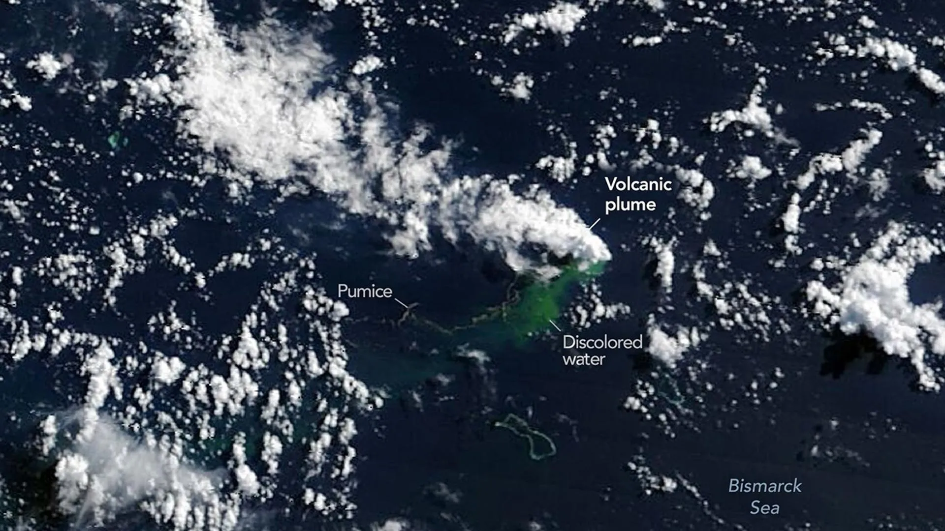
Initial satellite passes confirmed that magma was breaching the ocean floor, sending massive, steam-rich white plumes billowing into the atmosphere. Within days, the disturbance escalated, generating ash clouds that climbed several kilometers high, turning surrounding waters a stark milky-turquoise, and launching expansive fields of floating volcanic rock known as pumice rafts.
According to data collected by thermal imaging instruments, the eruption is generating massive heat signatures. The scale of these anomalies has stunned researchers, implying that the active volcanic vent may be significantly shallower than what existing regional bathymetry maps suggest. While older maps indicate water depths of several hundred meters in the area, the intensity of the surface thermal anomalies points to a surprisingly shallow, highly energetic conduit system.
Despite the pyrotechnics, experts emphasize that this event is behaving very differently from the cataclysmic, explosive submarine eruptions seen in recent years, such as the catastrophic Hunga Tonga-Hunga Ha’apai blast in 2022 or the Fukutoku-Okanobain eruption in 2021. Because Titan Ridge is situated near the intersection of a transform fault and a back-arc spreading center—rather than a traditional, highly pressurized subduction zone stratovolcano—volcanologists predict the activity will remain relatively mild, characterized primarily by effusive lava flows, steam explosions, and the steady accumulation of fragmental tephra.
Chronology of the Event
The unfolding drama in the Central Bismarck Sea has been meticulously documented by an orbital relay of satellites, capturing the escalation of the crisis day by day:
- May 8, 2026 (Seismic Onset): Regional seismic networks register an unexpected swarm of small earthquakes originating beneath the Central Bismarck Sea, signaling subsurface magma movement along Titan Ridge.
- May 9, 2026 (Atmospheric Plumes): NASA’s Aqua and Terra satellites capture the first visual confirmation of the event, imaging dense, white, steam-rich volcanic plumes rising from the sea surface. Simultaneously, NASA’s PACE (Plankton, Aerosol, Cloud, Ocean Ecosystem) satellite detects massive swathes of discolored, disturbed water surrounding the eruption zone.
- May 10–11, 2026 (Ash and High-Resolution Imaging): Ash plumes reach several kilometers into the atmosphere. High-resolution optical sensors aboard the European Space Agency’s Sentinel-2 and NASA/USGS Landsat 9 provide sharp views of the ocean surface disturbance. False-color infrared imagery (utilizing bands 7-6-5) highlights intense thermal signatures breaking the ocean surface.
- May 12, 2026 (Thermal Anomalies Expand): The Visible Infrared Imaging Radiometer Suite (VIIRS) aboard the Suomi NPP satellite identifies massive thermal anomalies covering an estimated seven square kilometers, confirming a continuous, large-scale release of high-temperature material near the surface.
- Mid-May 2026 and Onward (Pumice Rafts and Surface Evolution): Medium- and high-resolution sensors from government and commercial constellations track expanding fields of floating pumice stones being sheared and stretched into long bands by regional surface currents, while scientists anxiously monitor for the emergence of permanent land.
Supporting Data & Technical Observations
The wealth of data flowing from Earth orbit has allowed scientists to dissect the Bismarck Sea eruption with a precision previously impossible for deep-water events.
The inclusion of NASA’s PACE satellite has been particularly vital. Designed primarily to study ocean biology, PACE’s advanced ocean color sensor has proven exceptionally adept at mapping the dispersion of volcanic ash, micro-particulates, and iron-rich hydrothermal fluids discharged into the water column. The resulting discoloration maps provide a dynamic fluid-dynamics proxy for tracking the intensity and pulsing nature of the sub-surface vent.
Furthermore, the thermal anomaly data captured by the Suomi NPP satellite’s VIIRS instrument on May 12 remains a focal point of scientific analysis. Spanning roughly seven square kilometers, the thermal footprint indicates an extraordinarily high volume of hot material lingering near the ocean-atmosphere interface.
"There must be a lot of hot material near the surface to generate so many thermal anomalies," noted Dr. Simon Carn, a prominent volcanologist at Michigan Tech. "This suggests a fairly shallow eruption vent—much shallower than what’s implied by the existing bathymetry, which shows water depths of several hundred meters or more."
Compounding the mystery is the unpredictable lifespan of Bismarck Sea volcanic events. Historical precedent in the region offers wildly contrasting timelines: a submarine eruption roughly 100 kilometers away in the St. Andrew Strait continued near-continuously for nearly four years after beginning in 1957, whereas another nearby submarine event in 1972 sputtered out after a mere four days. Whether Titan Ridge will build a lasting geological monument or quickly fade back into the deep remains an open question.
Official Responses & Expert Perspectives
The scientific community has responded to the Bismarck Sea event with a mixture of professional awe and strategic planning. The eruption is viewed not merely as a localized geological hazard, but as a premier, real-time research opportunity.
"The good news is that there are huge opportunities to explore and learn using both government and commercial satellite platforms already in orbit," stated Jim Garvin, chief scientist at NASA’s Goddard Space Flight Center. Garvin has been a leading advocate for leveraging multi-agency orbital assets to observe transient Earth processes.
Garvin and a multidisciplinary coalition of researchers are already coordinating follow-up observations. Plans are underway to deploy advanced radar data streams—specifically utilizing the upcoming NASA-ISRO NISAR (Synthetic Aperture Radar) satellite and the Canadian Space Agency’s RADARSAT Constellation Mission. These radar systems possess the unique ability to peer through volcanic ash clouds and darkness, using microwaves to measure millimeter-scale changes in topography should a new landmass break the surface of the water.
Commenting on the safety and potential hazards of the ongoing event, Dr. Carn reassured stakeholders that a catastrophic, Hunga Tonga-style explosion is improbable. "Spreading centers are associated with less explosive activity, while the most explosive eruptions are usually along subduction zones and involve large stratovolcanoes," Carn explained.
Nevertheless, authorities in Papua New Guinea and maritime agencies in the region have issued cautionary advisories to shipping vessels and aircraft, warning of navigational hazards posed by the abrasive, dense pumice rafts and unexpected localized turbulence near the eruption coordinates.
Implications: The Potential Birth of an Island Laboratory
Perhaps the most enticing prospect of the Titan Ridge eruption is the possibility that it will give birth to a brand-new island.
"We’re now eagerly waiting to see if a new island is about to be born—something that we’ve only rarely been able to observe with satellites as it happens," NASA’s Jim Garvin remarked.
If land successfully breaches the surface and manages to anchor itself against the battering waves of the Bismarck Sea, it will face a precarious evolutionary fork in the road. The volcano could construct a stable tuff cone featuring a long-lived vent crater, anchoring its presence in the Pacific. Conversely, like many ephemeral submarine constructions, the newly formed land could rapidly collapse under its own weight, succumbing to marine erosion within weeks or months. Furthermore, scientists warn that if ocean water manages to breach a developing, shallow magma chamber within the juvenile volcanic edifice, the character of the eruption could rapidly shift from effusive to violently explosive.
Should a permanent island survive, however, it promises to transform into an invaluable natural laboratory. Garvin envisions a scenario where researchers—whom he playfully dubs "island-nauts"—can step ashore to study the primary succession of life from absolute zero.
Similar to the intense scientific fascination that followed the post-eruption evolution of Hunga Tonga-Hunga Ha’apai, a new Bismarck Sea island would allow biologists, geomorphologists, and climatologists to document the step-by-step colonization of sterile volcanic rock by microbes, plants, and migratory seabirds. Scientists could study how chemical weathering, rainfall, and hydrodynamic erosion carve out a nascent landscape in real time.
Garvin also draws a philosophical and operational parallel between studying newborn Earth islands and preparing humanity for future planetary exploration. As space agencies gear up for crewed lunar returns via NASA’s Artemis program, observing how planetary materials behave, erode, and support rudimentary biology under extreme conditions offers profound terrestrial analogs for planetary science.
"This new eruption could present an even better opportunity for ‘island-naut’ exploration as we prepare to return to the Moon with women and men via Artemis IV," Garvin concluded.
For now, the eyes of the world—both on the ground and hundreds of miles above it in the cold vacuum of space—remain locked on Titan Ridge, waiting to see what the restless depths of the Bismarck Sea will yield next.
