

PAPUA NEW GUINEA — Humanity has long possessed a paradoxical relationship with spatial exploration. We have mapped the celestial topography of the Moon and Mars with breathtaking, millimeter-level precision, yet vast reaches of our own planet’s aquatic domains remain profoundly mysterious. Oceanographers frequently remind the scientific community that we know less about the deep ocean floor than we do about the surfaces of neighboring celestial bodies.
This stark contrast is nowhere more apparent than in the Bismarck Sea, located immediately north of Papua New Guinea. Despite its striking geological complexity—a chaotic theater defined by deep-sea faults, volcanic structures, rifts, scarps, and active subduction and spreading zones—the local seafloor remains woefully under-mapped. Many of these dynamic geological features lie at abyssal depths that render conventional sonar mapping extraordinarily difficult, slow, and expensive.
However, on May 8, 2026, the veil concealing this aquatic frontier was momentarily pierced. A sudden, unexpected submarine volcanic eruption erupted into public view, not through ships on the water, but through the watchful eyes of orbiting satellites. This seismic and volcanic event has provided scientists with a rare, real-time window into the subterranean forces shaping the Earth’s crust, while sparking tantalizing questions: Could we be witnessing the birth of a brand-new island?
Main Facts
The subterranean awakening in the Central Bismarck Sea began quietly on May 8, 2026, when regional seismometers registered an uncharacteristic swarm of low-magnitude earthquakes. Within hours, spaceborne instruments corroborated what the seismic data hinted at: a submarine volcanic eruption was actively breaching the ocean’s surface.
Current geological assessments suggest the activity is centered along Titan Ridge, situated roughly 16 kilometers (10 miles) southeast of a historical underwater eruption site that last stirred in 1972. Despite the unprecedented array of modern remote-sensing tools, fundamental mysteries persist. Researchers cannot yet say with absolute certainty which specific volcanic feature is venting, how deep the active vent originally sat beneath the waves, or precisely when this specific structure last awakened.
Nevertheless, the event has galvanized the global volcanology and oceanography communities.
"The good news is that there are huge opportunities to explore and learn using both government and commercial satellite platforms already in orbit," noted Jim Garvin, chief scientist at NASA’s Goddard Space Flight Center.
The eruption features several hallmark phenomena:
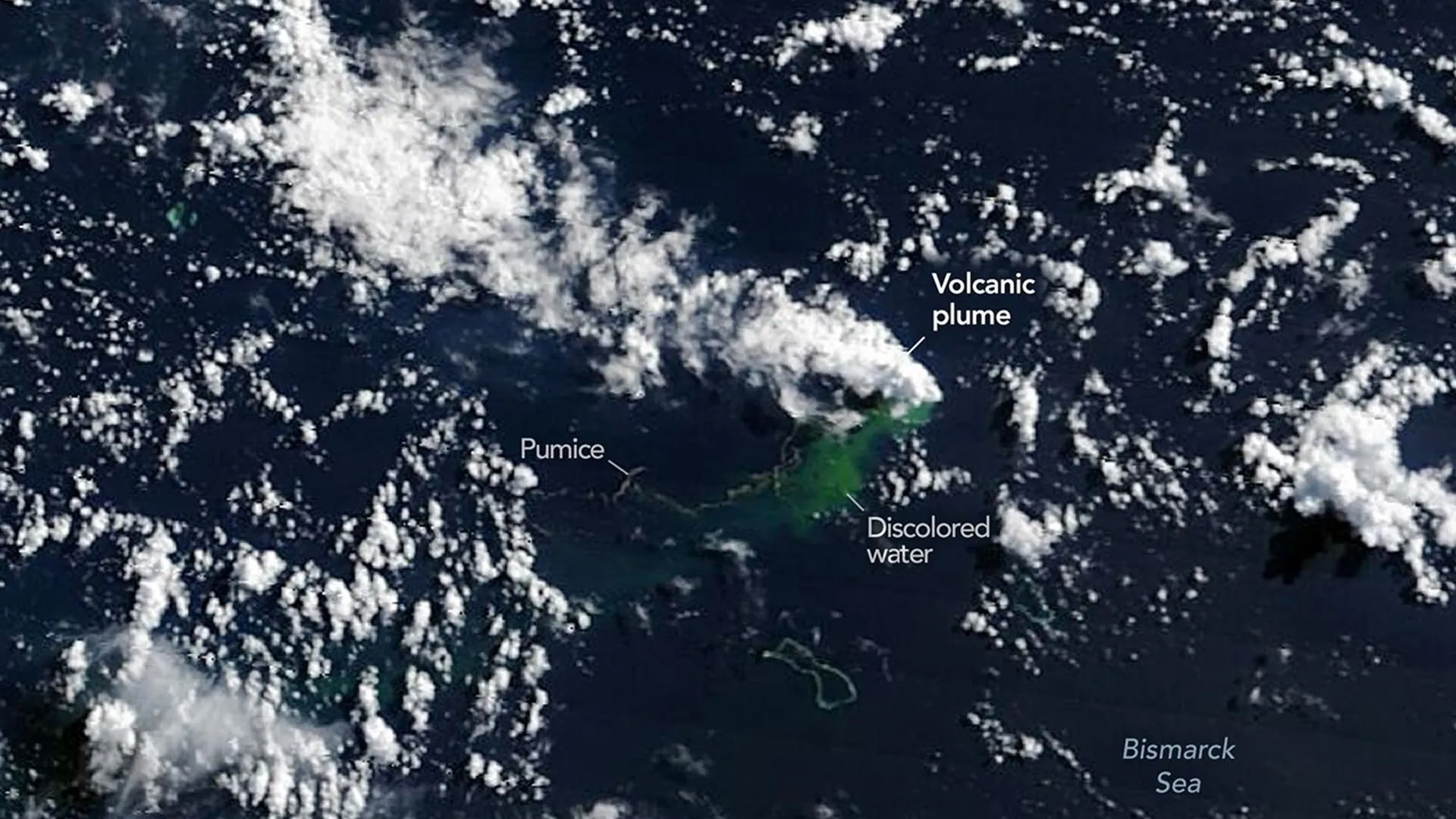
- Volcanic Plumes: Dense, white, steam-rich plumes alongside high-altitude ash columns.
- Thermal Anomalies: Massive heat signatures spanning square kilometers of open ocean.
- Pumice Rafts: Expansive fields of floating volcanic rock stretching across the sea surface.
- Discolored Waters: Broad swathes of chemically altered and disturbed marine water surrounding the vent site.
Unlike the cataclysmic, highly explosive blasts witnessed at Hunga Tonga-Hunga Ha’apai in 2022 or Fukutoku-Okanobain 2021, the Bismarck Sea event has remained relatively mild. Experts attribute this tamer behavior to the tectonic setting: Titan Ridge sits near the intersection of a transform fault and a back-arc spreading center, environments historically associated with effusive, less violent activity compared to subduction-zone stratovolcanoes.
Chronology of an Eruption: From Seismometers to Space
The unfolding drama in the Bismarck Sea played out over a tightly compressed timeline, tracked step-by-step by an international constellation of Earth-observation satellites.
May 8, 2026: The Seismic Trigger
The sequence of events commenced with a localized swarm of earthquakes detected by seismic monitoring networks. While minor on the Richter scale, the clustering and shallow focal depths of the tremors strongly signaled magmatic movement beneath the ocean floor.
May 9, 2026: Orbital Confirmation
As word of the seismic activity spread, NASA’s twin Earth-observing satellites, Aqua and Terra, captured the first direct visual evidence of the submarine awakening. Their wide-swath imagers recorded billowing white, steam-rich volcanic plumes punching through the marine boundary layer into the atmosphere. Simultaneously, the ocean color sensor aboard NASA’s state-of-the-art PACE (Plankton, Aerosol, Cloud, Ocean Ecosystem) satellite revealed vast expanses of milky, discolored, and chemically disturbed water swirling around the hidden eruption point.
May 10–11, 2026: High-Resolution Surveillance
The activity escalated visually as ash plumes climbed several kilometers into the sky. High-resolution imaging systems—specifically the European Space Agency’s Sentinel-2 and the joint NASA/USGS Landsat 9 satellites—zeroed in on the site. By processing these images through specialized false-color configurations (notably bands 7-6-5), researchers isolated distinct infrared signatures, confirming intense thermal activity bubbling near the ocean surface.
May 12, 2026: Thermal Mapping and Scale
On May 12, the VIIRS (Visible Infrared Imaging Radiometer Suite) instrument, flying aboard the Suomi NPP satellite, quantified the scope of the event. VIIRS thermal anomalies detected a staggering heat footprint covering approximately seven square kilometers of the Central Bismarck Sea.
"There must be a lot of hot material near the surface to generate so many thermal anomalies," explained Simon Carn, a volcanologist at Michigan Tech. "This suggests a fairly shallow eruption vent—much shallower than what’s implied by the existing bathymetry, which shows water depths of several hundred meters or more."
Supporting Data and Technical Insights
To understand the magnitude and rarity of the Bismarck Sea event, scientists are relying heavily on multi-spectral satellite telemetry, comparative volcanology, and historical precedents in the region.
The Thermal Footprint and Vent Depth
The thermal anomalies captured by the Suomi NPP satellite’s VIIRS instrument offer critical clues regarding the architecture of the volcano. A heat signature spanning seven square kilometers at the ocean surface cannot be maintained by deep-sea venting alone; heat rapidly dissipates in the immense volume of the ocean. The persistence and intensity of the thermal data corroborate Dr. Carn’s hypothesis that the active conduit must be significantly shallower than previously mapped bathymetric charts indicate, pointing to a dynamic, rapidly building volcanic edifice.
Comparative Tectonic Context
Volcanologists distinguish between types of submarine eruptions based on their tectonic settings:
| Eruption Event | Year | Tectonic Setting | Explosivity Level | Key Characteristics |
|---|---|---|---|---|
| Hunga Tonga | 2022 | Subduction Zone | Extreme (Cataclysmic) | Massive atmospheric shockwaves, global stratospheric water vapor injection. |
| Fukutoku-Okanoba | 2021 | Subduction Zone | High | Substantial pumice rafting, explosive ash columns. |
| Bismarck Sea (Titan Ridge) | 2026 | Spreading Center / Transform Fault Intersection | Moderate / Mild | Dominated by steam plumes, broad thermal anomalies, extensive pumice fields, minimal explosive violence. |
Because Titan Ridge is governed by extensional forces at a spreading center, the magma feeding the eruption is typically basaltic and low in volatile pressures compared to the water-rich, calc-alkaline magmas fueling subduction-zone stratovolcanoes. This reduces the risk of a catastrophic caldera collapse, though localized hazards remain.
Historical Precedents in the Region
Submarine volcanism is not entirely unknown in the waters north of Papua New Guinea, though capturing them with modern satellite constellations is unprecedented.
- The 1972 Event: Located roughly 16 kilometers northwest of the current Titan Ridge activity, a previous submarine eruption occurred in this immediate area, though it proved short-lived, subsiding after just four days.
- The St. Andrew Strait Event: Situated roughly 100 kilometers away, a major submarine eruption began in 1957 and persisted for nearly four continuous years, demonstrating that Bismarck Sea volcanism can span vastly different temporal scales.
Whether the 2026 eruption will emulate the fleeting four-day lifespan of its 1972 neighbor or settle into a multi-year slog like the St. Andrew Strait event remains an open question.
Official Responses and Scientific Perspectives
The international scientific community has mobilized rapidly, transforming the remote Bismarck Sea into a focal point for modern remote-sensing geology. Space agencies and academic institutions are pooling resources to track the event without putting researchers immediately in harm’s way.
Jim Garvin of NASA’s Goddard Space Flight Center has been vocal about the broader implications of the event, particularly regarding the potential birth of new land.
"We’re now eagerly waiting to see if a new island is about to be born—something that we’ve only rarely been able to observe with satellites as it happens," Garvin stated.
If the continuous outpouring of pumice, ash, and solidified lava succeeds in breaching the sea surface permanently, geologists anticipate a fierce battle between construction and destruction. Newly emerged volcanic islands—often composed of loose, unwelded pyroclastic material known as tuff cones—are notoriously fragile. Without durable hard-rock capping, wave action, marine currents, and heavy tropical rainfall can rapidly erode nascent landmasses back beneath the waves.
Furthermore, Garvin notes a critical hazard threshold:
"There is also the possibility that the eruption could become significantly more explosive if seawater reaches the shallow magma chamber developing within the growing underwater volcano."
When cold seawater suddenly mixes with hot, rising magma, it can trigger fuel-coolant interactions, instantly flashing water to steam and driving violent, phreatomagmatic explosions capable of generating localized tsunamis and hurling ballistic debris across the surface.
Implications: A Natural Laboratory for "Island-Nauts"
Beyond the immediate geophysical spectacle, the Titan Ridge eruption offers a profound scientific opportunity. Dr. Garvin and an interdisciplinary team of researchers are preparing to deploy advanced radar assets to monitor the site continuously.
Plans are already underway to utilize synthetic aperture radar (SAR) data from upcoming and active orbital platforms, including the NASA-ISRO NISAR satellite and the Canadian Space Agency’s RADARSAT Constellation Mission. Unlike optical cameras, which are often blocked by dense volcanic ash clouds and tropical weather, radar wavelengths can pierce the atmosphere day or night, allowing scientists to measure topographical changes, calculate volume accumulation, and map the precise shape of any landmass that breaks the surface.
Should the eruption succeed in stabilizing a permanent island, it will transform into an invaluable natural laboratory. Garvin affectionately refers to the researchers who would study such a pristine environment as "island-nauts."
Much like the intensive post-eruption studies conducted following the Hunga Tonga-Hunga Ha’apai eruption, a new Bismarck Sea island would allow biologists, geomorphologists, and ecologists to observe the planet’s regeneration processes from day zero:
- Primary Succession: Tracking how airborne microbes, drifting seeds, and pioneering marine birds colonize barren, sterile volcanic rock.
- Geomorphic Evolution: Measuring the rates at which tropical rainfall, chemical weathering, and ocean wave dynamics sculpt and erode the brand-new landscape.
- Planetary Analogs: Providing terrestrial analogs for volcanic processes and landscape evolution on other rocky worlds, a pursuit gaining urgency as NASA prepares for crewed lunar exploration under the Artemis IV mission.
"This new eruption could present an even better opportunity for ‘island-naut’ exploration as we prepare to return to the Moon with women and men via Artemis IV," Garvin reflected.
As satellites continue their silent orbits overhead, beaming down high-resolution imagery of white steam plumes, turquoise thermal scars, and drifting ribbons of pumice, humanity watches a primal terrestrial chapter unfold. In the shadowed depths of the Bismarck Sea, the Earth is remodeling itself—and for the first time in history, our eyes in space are catching every moment of creation.
