

PORT MORESBY, PAPUA NEW GUINEA — Oceanographers frequently note a humbling paradox of modern science: human researchers have mapped the surfaces of the Moon and Mars in greater detail than much of Earth’s deep ocean. This contrast is nowhere more striking than in the Bismarck Sea, located north of Papua New Guinea. Despite its remarkable geological complexity—a chaotic matrix of faults, volcanic structures, rifts, scarps, and active subduction and spreading zones—the local seafloor remains poorly understood. Much of the region lies at depths that make high-resolution sonar mapping extraordinarily difficult, leaving vast blind spots in our understanding of Earth’s crustal dynamics.
That veil of ignorance was dramatically pierced on May 8, 2026, when global monitoring networks detected the unmistakable signatures of an unexpected submarine volcanic eruption in the Central Bismarck Sea.
Initial seismological data and a constellation of Earth-observation satellites quickly confirmed that subterranean forces had breached the ocean floor along Titan Ridge. This site sits approximately 16 kilometers (10 miles) southeast of a historical underwater eruption that occurred in 1972. Yet, even with cutting-edge orbital technology streaming data back to Earth, scientists still cannot say with absolute certainty which specific volcanic feature is erupting, the precise depth of the active vent, or when the structure last awakened.
Chronology of an Awakening: From Seismic Swarm to Orbital Detection
The sequence of events unfolded rapidly across a few short days in early May, transforming an invisible deep-sea disturbance into a global scientific event tracked from space.
- May 8, 2026: Seismometers first record an unexpected, localized swarm of small earthquakes beneath the Central Bismarck Sea. Almost simultaneously, satellite systems capture the initial anomalies indicating a subsurface breach.
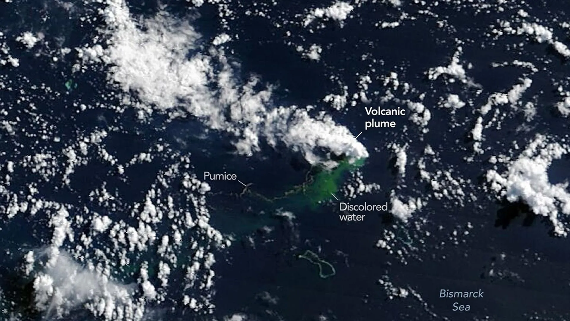
- May 9, 2026: NASA’s Aqua and Terra satellites capture stark visual evidence of the unfolding event, imaging billowing white, steam-rich volcanic plumes punching through the ocean surface and rising into the atmosphere. Concurrently, the ocean color sensor aboard NASA’s PACE (Plankton, Aerosol, Cloud, Ocean Ecosystem) satellite detects sprawling expanses of discolored, sediment-laden water churning around the eruption zone.
- May 10–11, 2026: Ash plumes are observed climbing several kilometers into the sky. Higher-resolution orbital sensors—specifically the European Space Agency’s Sentinel-2 and the joint NASA/USGS Landsat 9—provide sharp, detailed imagery of the tumultuous activity near the ocean surface. False-color processing (utilizing bands 7-6-5) vividly highlights the intense infrared signature of the eruption.
- May 12, 2026: The VIIRS (Visible Infrared Imaging Radiometer Suite) instrument aboard the Suomi NPP satellite pinpoints massive thermal anomalies spanning roughly seven square kilometers. This thermal footprint confirms that sustained, high-energy magmatic activity is actively modifying the shallow marine environment.
Supporting Data and Geophysical Analysis
The multi-agency satellite campaign has provided volcanologists and oceanographers with an unprecedented window into a deep-sea eruption in real time, bypassing the immediate logistical challenges of deploying crewed vessels to a remote maritime zone.
The sheer scale of the thermal anomalies detected by the Suomi NPP satellite on May 12 caught many researchers by surprise. Covering an area of approximately seven square kilometers, the heat signature implies that immense volumes of superheated material are residing unusually close to the air-sea interface.
"There must be a lot of hot material near the surface to generate so many thermal anomalies," said Simon Carn, an expert volcanologist at Michigan Tech. "This suggests a fairly shallow eruption vent—much shallower than what’s implied by the existing bathymetry, which shows water depths of several hundred meters or more."
Furthermore, surface manifestations have been exceptionally dynamic. Observers note large plumes of discolored water, numerous steam and ash vents, and expansive pumice rafts—fields of lightweight, gas-rich volcanic rock floating on the ocean’s surface. Medium- and high-resolution sensors operated by both government agencies and commercial satellite constellations have successfully tracked these floating pumice fields as they stretch into elongated bands, propelled across the Bismarck Sea by prevailing surface currents.
Despite the pyrotechnics, experts emphasize that this event is considerably less explosive than other recent, high-profile submarine eruptions, such as the catastrophic Hunga Tonga-Hunga Ha’apai explosion in 2022 or the Fukutoku-Okanobain eruption in 2021.
According to Carn, a dramatic escalation into a cataclysmic blast remains unlikely due to the tectonic setting of Titan Ridge. The ridge sits near the intricate intersection of a transform fault and a back-arc spreading center.
"Spreading centers are associated with less explosive activity, while the most explosive eruptions are usually along subduction zones and involve large stratovolcanoes," Carn explained.
Yet, uncertainty shrouds the event’s longevity. Subsurface volcanic plumbing systems are notoriously fickle. For context, a nearby submarine eruption in the Bismarck Sea in 1972 lasted a mere four days, whereas another volcanic event roughly 100 kilometers away in the St. Andrew Strait continued discharging material for nearly four years after its onset in 1957.
Official Responses and Strategic Monitoring
The unexpected awakening of the Titan Ridge vent has mobilized an international coalition of space agencies and Earth scientists. Rather than relying solely on traditional oceanographic research vessels—which take weeks to mobilize and reach remote oceanic tracts—the scientific community is leaning heavily on orbital assets.
"The good news is that there are huge opportunities to explore and learn using both government and commercial satellite platforms already in orbit," noted Jim Garvin, the chief scientist at NASA’s Goddard Space Flight Center.
Garvin and a multidisciplinary team of researchers are orchestrating a coordinated monitoring protocol. As the eruption evolves, they plan to deploy advanced radar data from the upcoming NASA-ISRO NISAR satellite and the Canadian Space Agency’s RADARSAT Constellation Mission. These synthetic aperture radar systems possess the unique capability to peer through atmospheric smoke and cloud cover, mapping any newly formed landmasses down to the centimeter and measuring volumetric changes in topography over time.
Local authorities in Papua New Guinea, alongside maritime transit agencies, have also been alerted to the hazards posed by the floating pumice rafts, ash plumes, and unexpected water displacement near the eruption coordinates. While shipping lanes in the Bismarck Sea are being managed with localized advisories, the primary focus of the official response remains scientific observation and risk assessment.
Broader Implications: The Potential Birth of a Natural Laboratory
Beyond the immediate geophysical interest, the Bismarck Sea eruption has triggered intense speculation within the scientific community regarding a rare geological phenomenon: the birth of a brand-new island.
"We’re now eagerly waiting to see if a new island is about to be born—something that we’ve only rarely been able to observe with satellites as it happens," Garvin said.
If the continuous output of tephra, lava, and pumice successfully breaches the surface and consolidates against wave erosion, a permanent or semi-permanent landmass could emerge. Scientists are closely modeling the potential trajectories of this nascent island. The volcano could construct a stable tuff cone featuring a long-lived vent crater, or, conversely, the newly accumulated land could quickly succumb to structural collapse and marine erosion, washing away beneath the waves just as quickly as it formed.
An additional, albeit lower-probability, risk involves the interaction of seawater with the shallowing magma chamber. Should seawater gain direct access to the concentrated, highly pressurized magma reservoir beneath the growing underwater structure, the eruption style could pivot rapidly, turning significantly more explosive.
Should the landmass endure, however, it stands to become an invaluable scientific asset. Garvin envisions the emergent island functioning as an exceptional natural laboratory. He refers to the researchers who would study it as "island-nauts."
Just as biologists and geologists descended upon the newly formed landmasses following the Hunga Tonga-Hunga Ha’apai eruption, researchers at Titan Ridge would have a pristine canvas to observe foundational ecological and geological processes in real time. Scientists could document how pioneer species—plants, microbes, and marine birds—colonize barren rock from scratch. Furthermore, they could study how rainfall, thermal activity, and chemical weathering rapidly reshape a virgin landscape, offering vital insights into planetary geomorphology.
Garvin links this terrestrial frontier back to humanity’s broader spirit of exploration, noting the serendipitous timing as international space programs look toward the future.
"This new eruption could present an even better opportunity for ‘island-naut’ exploration as we prepare to return to the Moon with women and men via Artemis IV," he concluded.
As the satellites continue their silent orbits overhead, beaming down thermal data, radar imagery, and optical snapshots of a restless sea, the global scientific community watches and waits. Whether Titan Ridge ultimately sinks back into the abyss or gifts the Earth a brand-new island, the event has already proven to be a masterclass in the power of modern orbital surveillance, illuminating the dark, hidden depths of the Bismarck Sea.
