

JAKARTA, INDONESIA — In the early days of September 2026, the Sunda Strait—a vital maritime corridor separating the Indonesian islands of Java and Sumatra—became the stage for one of the most disruptive volcanic events in recent regional history. Anak Krakatau, the notoriously volatile "Child of Krakatoa," broke out of its routine baseline activity with a sustained, violent explosive phase that lasted more than 24 hours. The eruption sent plumes of gas, rock, and ash tens of thousands of feet into the atmosphere, throwing Indonesia’s aviation network into chaos, degrading air quality across densely populated metropolitan centers, and mobilizing disaster response agencies.
While Anak Krakatau is intimately familiar to volcanologists for its frequent, modest Strombolian bursts, the September 2026 event demonstrated the volcano’s capacity for rapid, high-impact escalation. The crisis paralyzed regional travel, raised urgent public health concerns, and served as a stark reminder of the geological perils inherent to the Pacific Ring of Fire.
Main Facts
The September 2026 eruption of Anak Krakatau was characterized by a potent combination of explosive gas emissions and massive ash ejection that caught both local populations and international observers by surprise.
Geographic and Geological Context
Anak Krakatau sits in the crucible of the Sunda Strait, emerging from the caldera left behind by the legendary, catastrophic 1883 eruption of Krakatoa. Because of its young age and active tectonic setting, it is in a constant state of growth and destabilization. Though its daily behavior typically oscillates between minor gas venting and low-level ash expulsions, it possesses the plumbing system necessary to shift into severe explosive phases rapidly.
The Scale of the Eruption
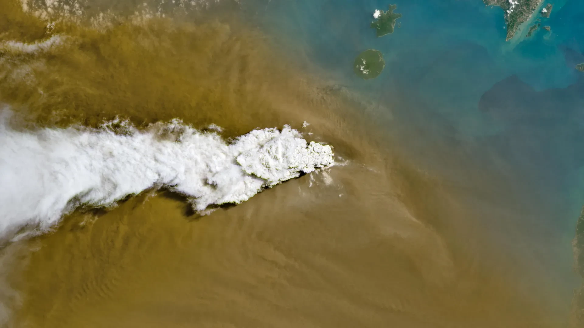
Beginning in early September 2026, the volcano initiated a prolonged explosive sequence that persisted continuously for over a day. Satellite observations documented dual-nature plumes: brilliant white columns of volcanic gas mixed with dark, dense brown clouds of tephra and ash. By September 6, Indonesian meteorological authorities confirmed that the eruption had achieved staggering vertical reach. Ash plumes had climbed as high as 6,000 meters (20,000 feet) to the east of the volcano, while ferocious upper-level atmospheric winds drove western plumes to altitudes reaching a blinding 15,000 meters (50,000 feet)—well into the cruising altitude of commercial jetliners.
Immediate Impacts
- Aviation Paralysis: The towering ash cloud necessitated the emergency closure of eight major airports across Java and Sumatra. Nearly 3,000 flights were delayed, canceled, or diverted, stranding tens of thousands of passengers.
- Environmental Degradation: Heavy ashfall blanketed communities east of the strait, stretching into the capital city of Jakarta and deep into West Java, choking the air and drastically reducing visibility.
- Public Health Risks: Fine silicate particles rained down on urban and rural populations, posing severe risks to respiratory health, ocular tissues, and skin integrity.
Chronology of the Crisis
The unfolding of the Anak Krakatau crisis followed a rapid, tense timeline over the first week of September 2026, transitioning from sudden geological violence to coordinated recovery efforts.
Late August to September 4: Building Pressure
For weeks prior, Anak Krakatau had maintained an elevated status on Indonesia’s national volcanic warning scale, holding steady at the second-highest alert level since July 2026. Subsurface movements and minor gas emissions hinted at shifting magma dynamics, but there was little external indication that a prolonged explosive phase was imminent.
September 5: The Eruption and Space-Based Observation
The volcano erupted violently, piercing the troposphere and sending vast quantities of particulate matter skyward.
- The NASA-USGS Landsat 8 Capture: On September 5, the Operational Land Imager (OLI) aboard Landsat 8 captured striking natural-color imagery of the volcano. The photographs revealed a stark white plume of high-pressure volcanic gas ascending powerfully above a dense, churning brown carpet of ash.
- Suomi NPP VIIRS Perspective: Concurrently, a broader view captured by the Visible Infrared Imaging Radiometer Suite (VIIRS) aboard the NASA/NOAA Suomi National Polar-orbiting Partnership (Suomi NPP) satellite illustrated the staggering lateral dispersion of volcanic material, mapping the ash hazard as it drifted across the maritime boundaries toward mainland populations.
September 6: Peak Altitude and Societal Disruption
By the morning of September 6, meteorological agencies registered the full extent of the atmospheric plume. The division of the plume—6,000 meters to the east and 15,000 meters to the west—unleashed widespread airborne hazards.
The Indonesian Humanitarian Coordination Platform (IHCP) issued its first flash updates as ash began to blanket communities downwind. At the same time, air navigation authorities took the unprecedented step of shutting down eight critical domestic and international transport hubs. Flight paths over the Sunda Strait were declared no-fly zones to prevent catastrophic jet engine failures caused by ingested molten glass and ash.
September 6–7: Weakening Paroxysm and Shift in Behavior
By the afternoon of September 6, the continuous, deafening roar of the sustained explosive phase began to subside. Volcanologists observed a drop in continuous tremor amplitudes, signaling a reduction in magma discharge rates. The eruption’s character transitioned away from the continuous convective column back toward a more periodic, classic Strombolian regime—characterized by rhythmic, discrete bursts of incandescent blocks, gas, and ash.
September 8: Resumption of Operations and Ongoing Vigilance
With the ash clouds gradually dissipating and shifting harmlessly over open ocean waters, aviation authorities deemed the airspace safe enough to reopen. By September 8, flights into Jakarta and neighboring regional airports resumed operations. However, despite the return to commercial normalcy, Indonesian authorities refused to lower the threat level, keeping Anak Krakatau firmly at the second-highest alert tier due to the unpredictable nature of its ongoing activity.
Supporting Data and Technical Observations
The 2026 Anak Krakatau eruption provided earth scientists with an unprecedented wealth of multi-spectral data, highlighting the critical role of modern satellite remote sensing in volcanic hazard management.
Satellite Remote Sensing Metrics
The acquisition of data by NASA Earth Observatory scientists—specifically Michala Garrison utilizing Landsat and VIIRS data from EOSDIS LANCE, GIBS/Worldview, and Suomi NPP—allowed authorities to track the plume in near-real-time.
- Thermal Anomalies: Infrared sensors detected elevated surface temperatures around the volcanic cone, indicating fresh magma pooling near the summit crater.
- Aerosol Tracking: Total column sulfur dioxide ($SO_2$) retrievals mapped the massive degassing associated with the magma ascent, shedding light on the volatile content feeding the eruption.
Aviation Hazard Thresholds
Volcanic ash is uniquely perilous to aviation because the silicate minerals within it melt at the high operating temperatures of jet turbines (roughly 1,200°C to 1,400°C). Once ingested, the molten rock coats turbine blades, solidifies in cooler sections of the engine, disrupts airflow, and can cause complete engine flameouts. The closure of eight airports underscored the strict zero-tolerance policies adopted by Indonesian aviation regulators following historical aviation close calls with ash clouds in the region.
Official Responses and Inter-Agency Coordination
Managing a multi-faceted disaster involving simultaneous airspace closures, environmental ashfall, and public health threats required a synchronized, multi-agency response across the Indonesian government and international scientific networks.
Aviation and Meteorological Authorities
Indonesia’s Badan Meteorologi, Klimatologi, dan Geofisika (BMKG), alongside the Ministry of Transportation, acted swiftly on September 5 and 6. By issuing immediate Notices to Air Missions (NOTAMs), they prevented commercial airliners from blundering into the dense, abrasive ash plumes. BMKG’s continuous tracking of wind patterns allowed civil protection teams to predict precisely which districts would receive the heaviest ash burdens, granting local municipalities precious hours to issue localized warnings.
Humanitarian Coordination and Public Health Interventions
The Indonesian Humanitarian Coordination Platform (IHCP) played a pivotal role on the ground, releasing detailed flash updates to coordinate aid, medical readiness, and public safety announcements.
Health authorities faced a unique communicative challenge: distinguishing the health risks of volcanic ash from concurrent environmental hazards. During the same week in September 2026, parts of Indonesia were battling severe peatland fires and associated haze. Public health officials had to aggressively educate the public that volcanic ash and wildfire smoke require distinct protective protocols.
- Volcanic Ash Hazards: Composed of sharp, jagged pulverized rock and glass, volcanic ash requires tightly sealed N95 or particulate respirators to prevent micro-abrasions in the lungs, alongside eye protection to prevent severe corneal irritation.
- Wildfire Smoke Hazards: Composed primarily of fine carbonaceous particulate matter ($PM_2.5$), volatile organic compounds, and carbon monoxide, smoke demands filtration focused heavily on gaseous toxins and microscopic soot.
Implications for the Future
The September 2026 eruption of Anak Krakatau is far more than a localized meteorological disruption; it is a profound lesson in systemic vulnerability and the relentless volatility of the Indonesian archipelago.
Economic and Infrastructure Vulnerability
The sudden grounding of nearly 3,000 flights exposed the profound economic fragility introduced by singular geological hazards in densely connected transport hubs. Jakarta, as a premier financial hub of Southeast Asia, relies on seamless regional connectivity. A single day of suspended operations reverberates through global supply chains, tourism revenues, and business logistics. Moving forward, aviation stakeholders are re-evaluating predictive modeling tools to allow for dynamic, corridor-specific rerouting rather than blanket airport shutdowns.
Scientific Advancements in Disaster Warning
The integration of high-resolution satellite imagery (Landsat 8 and Suomi NPP) with ground-based seismic telemetry has proven indispensable. The speed with which NASA and USGS data products were translated into operational insights demonstrates how far remote sensing has evolved. Yet, the persistent inability to predict when Anak Krakatau will transition from baseline rumbles to cataclysmic explosions highlights the limits of current volcanological forecasting.
Living in the Shadow of the Ring of Fire
Anak Krakatau remains a geologic entity in perpetual motion—building its cone only for subsequent eruptions to tear it down, much like the catastrophic collapse that triggered the deadly 1883 tsunami. As long as the volcano continues to sit at its elevated alert status, millions of residents across Java and Sumatra, alongside the regional aviation industry, must maintain eternal vigilance. The events of early September 2026 serve as a humbling reminder that humanity remains entirely secondary to the fiery, untamed forces shaping the Earth’s crust from beneath the Sunda Strait.
