

SOUTHAMPTON, UK — Long before the Colorado River began carving its iconic, labyrinthine path through the arid landscape of the American Southwest, an even more colossal geological drama was unfolding across the North American continent.
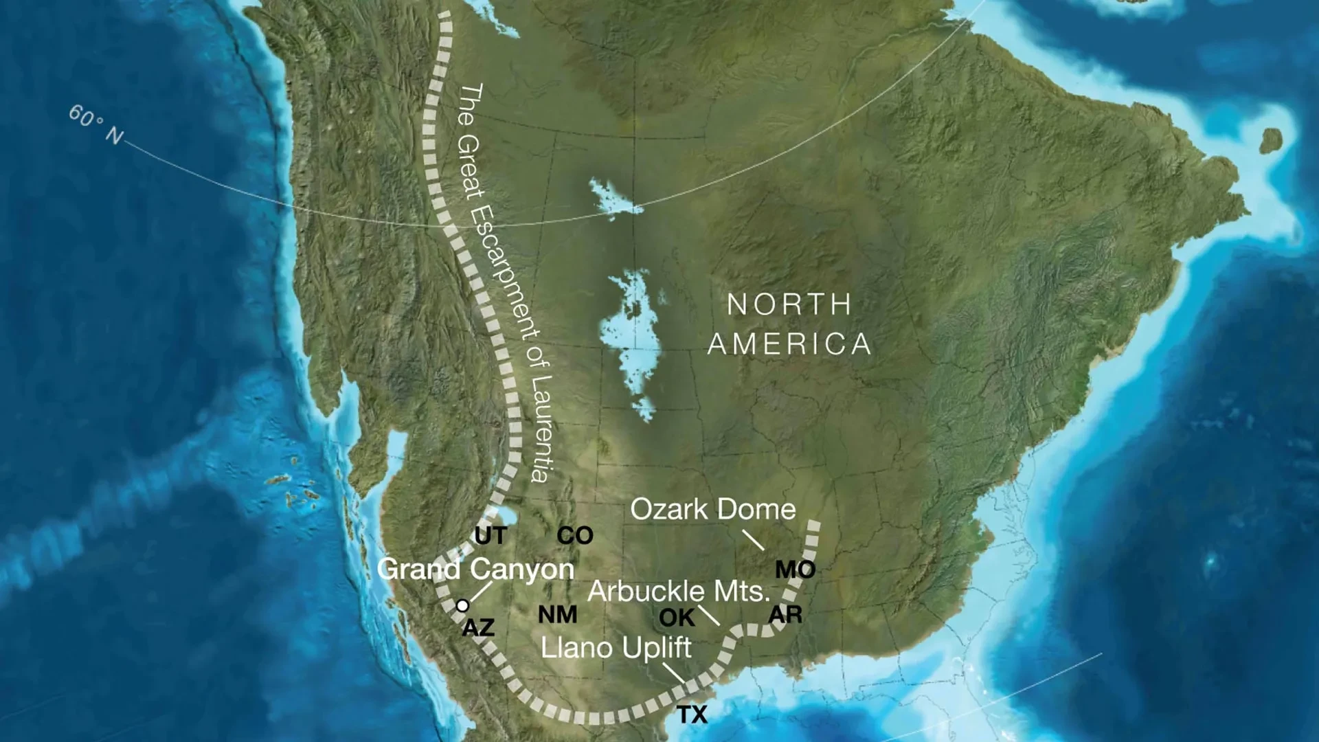
According to a groundbreaking study led by researchers at the University of Southampton, an enormous ancient cliff system—a towering "great escarpment" reaching roughly a kilometer in height—dominated western North America some 800 million years ago. Stretching for thousands of kilometers, this titanic topographical barrier was forged during the chaotic breakup of the ancient supercontinent Rodinia.
Published in the journal Geology, the research asserts that this long-lost escarpment played a pivotal role in exposing the deep crystalline basement rocks that now form the bedrock of the Grand Canyon in southern Arizona. The findings offer a compelling, paradigm-shifting explanation for one of Earth science’s most enduring mysteries: the Great Unconformity, a baffling gap in the geological record where more than a billion years of history appear to have simply vanished.
Main Facts
The study, which represents an international collaboration between researchers from the University of Southampton, the GFZ Helmholtz Centre for Geosciences and the University of Potsdam in Germany, and the University of Illinois Urbana-Champaign in the US, fundamentally reinterprets the early geological evolution of North America.
At the heart of the discovery is the identification of an immense ancient escarpment. Key facts emerging from the research include:
- Scale and Scope: The ancient cliff system is estimated to have reached heights of approximately one kilometer and extended over thousands of kilometers, crossing regions that today encompass modern-day Arizona, Utah, Idaho, Wyoming, Colorado, Texas, Oklahoma, Arkansas, Missouri, and Illinois.
- Timing: The escarpment formed approximately 800 million years ago, triggered by the tectonic rifting and fragmentation of the supercontinent Rodinia.
- Erosion and Exposure: Over tens of millions of years, relentless weathering and erosion along this massive boundary stripped away vast quantities of rock—estimates range between five and ten kilometers of vertical material in some areas—ultimately bringing ancient crystalline basement rocks to the surface.
- Solving a Geological Puzzle: The research directly addresses the Great Unconformity, shedding light on why large, highly variable chunks of the geological record are missing across the southwestern United States.
- Modern Analogs: By studying active, comparable escarpments in regions such as South Africa, Brazil, India, and Antarctica, the research team was able to model how ancient North America’s topography evolved and migrated inland over deep time.
Chronology of a Lost Landscape
To understand how a landscape from nearly a billion years ago relates to the modern Grand Canyon, scientists had to reconstruct a complex, multi-stage chronology bridging deep geological history with surface-level evolution.
Phase 1: The Fragmentation of Rodinia (approx. 1 Billion to 800 Million Years Ago)
Before the emergence of the escarpment, the Earth’s landmasses were assembled into a singular supercontinent known as Rodinia. As internal convective forces within the Earth’s mantle heated up, the supercontinent began to destabilize and pull apart. This continental rifting induced significant tectonic uplift, elevating massive blocks of the Earth’s crust along the rift margins.
Phase 2: Birth of the Great Escarpment (approx. 800 Million Years Ago)
As Laurentia—the ancient geological core of North America—tore away from neighboring continental blocks, it developed a steep, mountainous rift shoulder. This boundary manifested as a colossal "great escarpment," dropping precipitously from high interior plateaus down to newly forming oceanic basins. Towering roughly a kilometer high, this escarpment acted as a dominant geographical feature stretching across the heart of what would become North America.
Phase 3: Inland Migration and Deep Erosion (800 Million to 500 Million Years Ago)
Unlike stationary mountain ranges that simply wear down in place, major escarpments under specific tectonic regimes undergo scarp retreat—a process where the cliff face gradually migrates inland as erosion continually undercuts it. Over tens of millions of years, this dynamic erosive engine chewed through an immense thickness of the crust. The Southampton-led team estimates that this prolonged weathering removed anywhere from five to eight kilometers of rock in targeted zones. Crucially, this process planed down the upper layers, unearthing the deeply buried, ancient crystalline basement rocks that now sit at the bottom of the Grand Canyon.
Phase 4: The Phanerozoic and the Colorado River (Past 5 to 6 Million Years)
Long after the ancient escarpment had fulfilled its erosive destiny and the continent had continued its tectonic journey, a relative newcomer arrived on the scene: the Colorado River. Beginning a mere 5 to 6 million years ago, the river began utilizing the pre-conditioned weakness of the crust to rapidly incise the landscape, exposing the already-uncovered basement rocks and creating the majestic canyon seen by millions of tourists today.
Supporting Data and Methodology
Reconstructing a landscape that vanished hundreds of millions of years ago is no small feat. To achieve this, the research team pioneered a multidisciplinary approach, blending high-resolution plate tectonic reconstructions with quantitative landscape evolution models.
The scientists analyzed thermochronological data—a technique that measures the cooling history of minerals within rocks to determine when they were pushed toward the surface by erosion. By mapping these cooling signatures across western North America, the team confirmed that massive volumes of rock had indeed been stripped away from the region long before the modern drainage systems, such as the Colorado River, ever existed.
Furthermore, the team’s geological models demonstrated that when Rodinia fragmented, the geographic positioning of the future Grand Canyon relative to the continental edge bore a striking resemblance to active, modern-day escarpments found in South Africa and Brazil. These contemporary rifted margins are characterized by high ground, steep slopes, and dramatic escarpments that retreat inland over hundreds of millions of years while driving intense local erosion.
The predictive power of the team’s models aligned seamlessly with independent geological observations. Geologists have long noted that between five and ten kilometers of rock vanished from parts of the American Southwest during the late Precambrian era—a volumetric deficit that standard riverine erosion models struggled to fully account for. The introduction of the ancient escarpment hypothesis bridges this gap, providing a unified mechanical framework for the missing strata.
Official Responses and Expert Insights
Lead author Professor Thomas Gernon, a specialist in Earth science at the University of Southampton, emphasized that the discovery fundamentally reframes how geologists view North America’s most iconic natural wonder.
"The Grand Canyon preserves a geological history stretching back about two billion years, yet more than half of that rock record appears to be absent," Professor Gernon noted. "Our paper suggests the Canyon’s basement rocks were progressively brought to the surface as part of an immense escarpment that developed during the breakup of an ancient supercontinent."
Gernon explained that the tectonic uplift linked to continental rifting created the precise cocktail of steep slopes and high ground required to generate aggressive, sustained erosion.
"This long-lived tectonic landscape provides a missing piece in understanding why erosion associated with the Great Unconformity varies so dramatically across the southwestern US," Gernon said. "Our work suggests that tectonic uplift related to continental rifting and breakup created both steep slopes and high ground, providing the mountainous terrain that rivers and glaciers could readily erode."
Co-investigators from the international research team echoed these sentiments, highlighting that the study’s implications extend far beyond the borders of the United States. By demonstrating how continental breakup forces manifest as continent-spanning erosional engines, the research offers a new lens through which to examine other ancient cratons around the globe.
Broader Implications for Earth Science
The identification of this ancient megacliff system does more than tidy up the history of the Grand Canyon; it rewrites our understanding of how continental interiors evolve over deep geological time.
1. Solving the Great Unconformity
The Great Unconformity—first described by geologist John Wesley Powell during his pioneering 1869 expedition down the Colorado River—represents a frustrating gap where rock layers spanning hundreds of millions, or even over a billion years, are missing. The Southampton study provides a physical mechanism for this vast hiatus. By demonstrating that scarp retreat stripped away kilometers of crust across vast swaths of the continent, the research explains how such extensive unconformities can be carved out by tectonic and surficial processes operating in tandem.
2. Influencing Ancient Ecosystems and Climate
The presence of a towering, thousands-of-kilometers-long mountain rim around ancient Laurentia would have exerted a profound influence on Earth’s surface systems long before the rise of complex animal life. Such a massive topographical barrier would have fundamentally altered atmospheric circulation patterns, steered the paths of ancient rivers, dictated where thick blankets of sediment accumulated, and modulated the timing and extent of epicontinental seas advancing across the continent. These environmental shifts directly preceded the Cambrian explosion—the rapid diversification of complex multicellular life approximately 541 million years ago—raising intriguing questions about the interplay between tectonic landscapes and biological evolution.
3. A Global Reinterpretation Tool
In the closing remarks of their study, the researchers emphasized that modern escarpments in regions like Africa, Brazil, India, and Antarctica act as natural laboratories, offering direct windows into the forces that shape continents over hundreds of millions of years.
By utilizing these modern analogs to reinterpret the ancient history of the Grand Canyon, scientists now possess a powerful new heuristic tool. The methodology established by the Southampton-led team can be deployed by geologists working in other ancient continental interiors—such as parts of Australia, Scandinavia, and Siberia—where similarly puzzling stratigraphic gaps occur.
Ultimately, the research transforms our perception of the Grand Canyon. It is no longer viewed merely as the handiwork of the Colorado River cutting downward through passive stone, but rather as the modern beneficiary of an ancient, continental-scale mountain rim—a ghost landscape from a vanished world that prepared the canvas for one of Earth’s greatest natural masterpieces nearly a billion years before it was carved.
