

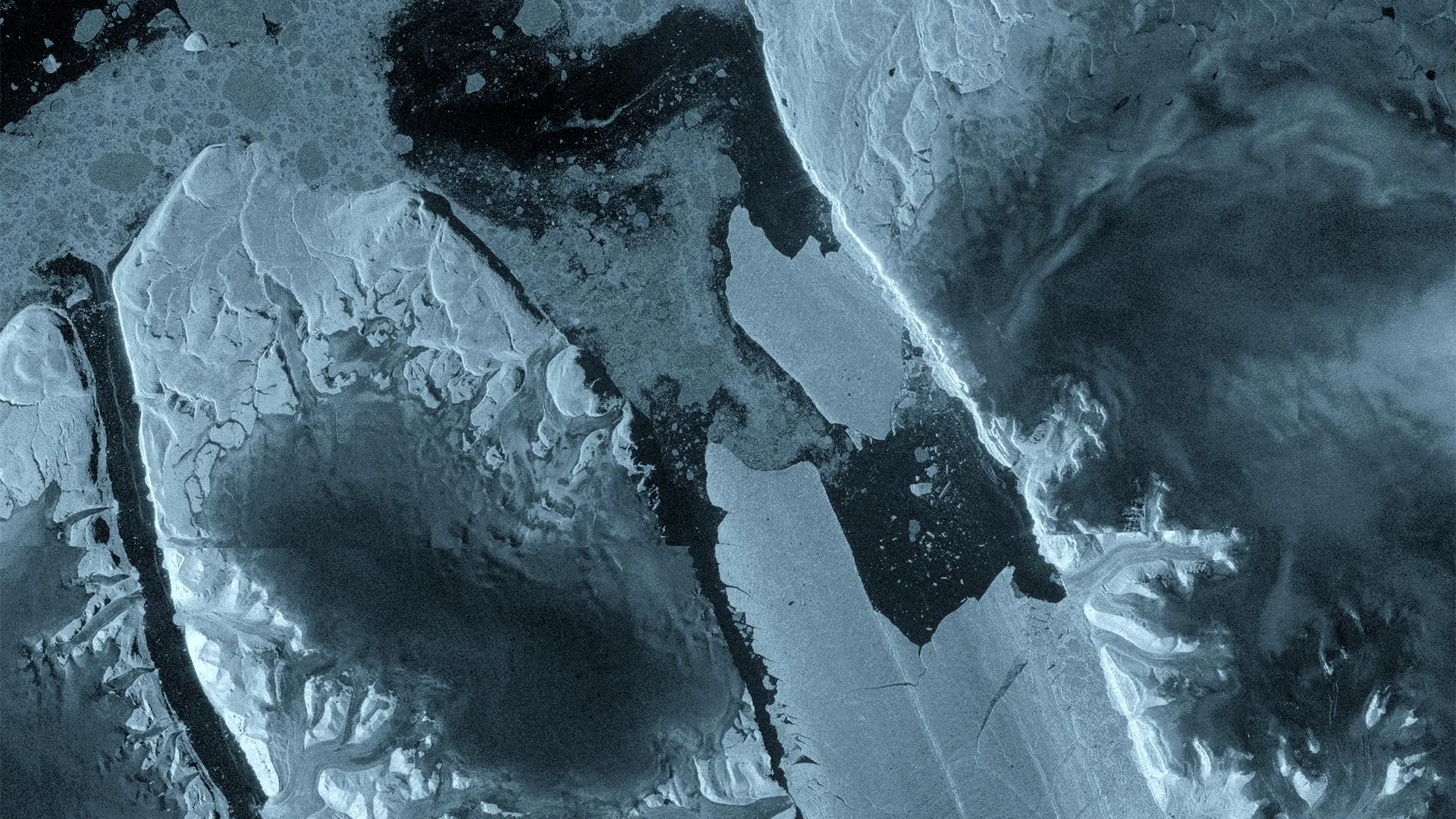
COPENHAGEN/OTTAWA — In a dramatic demonstration of the rapid and accelerating shifts reshaping Earth’s polar regions, Europe’s Copernicus Sentinel-1 mission has documented a massive calving event at the Petermann Glacier in northwest Greenland. On August 4, 2026, a staggering 76-square-kilometer section of the glacier’s floating ice tongue fractured and broke away, generating the largest loss of floating ice for the glacier since 2012 and marking the most significant Arctic calving event recorded since 2020.
The newly birthed tabular iceberg—colloquially referred to as an "ice island"—is roughly the scale of Manhattan and plunges an estimated 150 meters deep into the Arctic waters. While such colossal, flat-topped ice masses are a regular occurrence in the frigid waters surrounding Antarctica, they remain exceptionally rare in the Arctic. This rare phenomenon has provided an unprecedented natural laboratory for an international coalition of glaciologists, oceanographers, and environmental safety agencies tracking the destabilization of the cryosphere in near-real time.
Main Facts: Anatomy of a Colossal Break
The August 4 event was not a sudden anomaly, but rather the violent culmination of years of structural weakening within one of Greenland’s few remaining major marine-terminating ice tongues.
- The Scale of the Calving: The detached ice island spans 76 square kilometers—equivalent to the land area of Manhattan—and possesses a thickness reaching up to 150 meters.
- Historical Significance: This represents the largest ice loss for the Petermann Glacier in 14 years, since major calving cycles occurred in 2008, 2010, and 2012. It is also the largest Arctic calving event recorded since 2020.
- Technological Triumph: The breakup was captured by the European Space Agency’s (ESA) Copernicus Sentinel-1 radar satellites, leveraging a unique tandem observation phase between the Sentinel-1C and Sentinel-1D spacecraft to provide unprecedented one-day repeat synthetic aperture radar (SAR) data.
- Ongoing Threats: Beyond its scientific significance, the drifting ice island presents substantial logistical hazards. Canadian authorities are actively monitoring the colossal block as it threatens shipping lanes and offshore infrastructure in the Arctic Ocean.
- Potential for Future Failures: Scientists warn that the danger has not passed. Two additional massive ice islands, estimated at roughly 97 and 87 square kilometers respectively, remain precariously attached to the glacier and could break free as existing rifts continue to propagate.
Chronology: From First Fractures to the Final Rupture
The collapse of the Petermann ice tongue was tracked meticulously by an international research team comprising scientists from the University of Ottawa in Canada, the Universities of Stirling, Lancaster, and Leeds in the UK, and the Canadian Ice Service of Environment and Climate Change Canada. Their multi-year collaborative effort—partially funded through ESA’s FutureEO ARCTEX project—offers a detailed timeline of how the disaster unfolded.
The Foundation of Instability: 2019–2025
Since 2019, the international research collaborative has utilized Sentinel-1 imagery to monitor the health of the Petermann Glacier. Over several years, satellite data revealed expanding fractures, structural thinning, and growing evidence that the floating tongue was losing its structural integrity. Following a period of relative calm after the 2012 calving events, stress within the ice shelf began to compound under the influence of warming ocean currents and atmospheric forcing.
Spring 2026: The Deformation Becomes Visible
Interferometric observations collected over the Petermann Glacier in April 2026 provided scientists with their first high-resolution view of deep deformation and internal fractures developing within the floating ice tongue. These measurements gave researchers a window into the structural mechanics tearing the ice apart months before the eventual surface break.
August 3, 2026: Rapid Deterioration
By early August, the degradation accelerated dramatically. Radar images acquired by Sentinel-1 on August 3 revealed severe structural deterioration developing directly along the center of the ice tongue. The stress on the remaining structural "bridges" of ice reached a breaking point as ocean tides flexed the shelf upward and downward.
August 4, 2026: The Calving Event
Just 24 hours after the radar imagery revealed the central deterioration, the fracture lines propagated entirely through the ice shelf. On August 4, the 76-square-kilometer tabular iceberg cleanly separated from the glacier’s eastern side, drifting away into the fjord and beginning its long, perilous journey into the open ocean.
Supporting Data: The Power of SAR and Tandem Observations
The success of capturing this event in such granular detail is heavily attributed to the technical specifications and lucky timing of the Copernicus Sentinel-1 constellation.
Overcoming Arctic Obstacles
Monitoring remote polar glaciers has historically been plagued by logistical challenges, persistent cloud cover, and months of polar darkness where optical cameras are rendered useless. Sentinel-1 bypasses these limitations entirely. Utilizing active microwave radar instruments, the satellite can collect observations day and night while effortlessly piercing through thick cloud cover and polar storms.
The Sentinel-1C and -1D Tandem Phase
A defining breakthrough in monitoring this event was the unprecedented clarity of the interferograms generated in the lead-up to the collapse. This was made possible because the event coincided with the tandem commissioning phase of the newly launched Sentinel-1D satellite flying alongside Sentinel-1C.
This configuration allowed scientists to utilize one-day repeat synthetic aperture radar observations. By bouncing radar waves off the ice surface just 24 hours apart, researchers measured minute millimeter-scale movements, mapping how cracks spread across the ice shelf and how the surface of the ice tongue flexed in response to tidal forces right up until the moment of separation.
Official Responses and Expert Insights
The scientific community has responded to the Petermann Glacier event with a mixture of long-anticipated confirmation and urgency, highlighting the implications for global climate models.
Adam Garbo, a PhD student from the University of Ottawa who has spent years tracking the glacier, noted the historical weight of the moment:
"Petermann Glacier has long been one of Greenland’s largest remaining ice tongues. We’ve anticipated this break for years, and seeing it finally happen is remarkable. It’s a powerful reminder of how quickly these systems can change."
Dr. Anna Crawford from the University of Stirling emphasized the rarity and significance of studying Arctic tabular icebergs:
"While large, tabular icebergs are relatively common in the Southern Ocean around Antarctica, Arctic ice islands are far rarer. By studying Arctic ice islands, we will gain knowledge that can be transferred across polar regions. This is critical for understanding how the calving and deterioration of ice islands impact glacier dynamics, sea-level rise, and the ocean environment."
Molly Hammond, a PhD student from the University of Leeds who processed the complex Sentinel-1 data streams, highlighted the operational triumph of the satellite data:
"The changes we observed on Petermann Glacier were occurring very rapidly in the lead-up to the iceberg calving event, so it was incredibly exciting to monitor the crack propagation with interferometry in near-real time. This has demonstrated the incredible value of one-day repeat synthetic aperture data."
Martin Wearing of the European Space Agency (ESA) reflected on the broader context of Earth observation missions:
"This type of large tabular iceberg is relatively rare in the Arctic, making this calving event a unique opportunity to study how such a vast ice mass drifts, evolves, and eventually breaks apart. Satellite missions such as Sentinel-1 provide the systematic, long-term observations needed to track these changes, helping scientists better understand the processes driving calving and the wider impacts on the polar environment, and ultimately the Earth system as a whole."
Implications: Scientific, Environmental, and Navigational Risks
The birth of the Petermann ice island carries far-reaching consequences that extend well beyond the fjords of northwest Greenland, touching upon global sea-level dynamics, polar ecosystems, and maritime safety.
Glacier Dynamics and Sea-Level Rise
When floating ice shelves calve, the ice is already afloat in the ocean, meaning the immediate break does not directly raise global sea levels (much like ice melting in a glass of water does not overflow the rim). However, the loss of these massive floating tongues acts as a crucial "buttress" or brake against the land-based ice sheet behind them.
As extensive ice tongues like Petermann fracture and retreat, the structural back-pressure holding back the inland glaciers is reduced. This can accelerate the flow of grounded ice into the ocean, directly contributing to global sea-level rise over subsequent decades.
Threat of Future Calving
The immediate danger to the Petermann Glacier system may not be over. Researchers are closely monitoring two additional massive rifts cutting across the remaining ice tongue. These rifts delineate two potential future ice islands measuring approximately 97 square kilometers and 87 square kilometers, respectively. If ocean warming and tidal stresses continue at their current pace, these segments could also break away in the near future, radically altering the morphology of the glacier.
Maritime Safety and Practical Risks
On a practical level, the detachment of a Manhattan-sized block of ice poses severe, long-term risks to human activity in the Arctic. Environment and Climate Change Canada, alongside the Canadian Ice Service, is actively tracking the trajectory of the newly formed ice island.
Ice masses of this magnitude can persist in Arctic ocean currents for years. As they drift southward into narrow straits or shipping lanes, they gradually fragment into smaller, unpredictable tabular bergs and bergy bits. These smaller fragments become increasingly difficult to detect via standard maritime radar, presenting a persistent and hazardous obstacle to commercial shipping, fishing fleets, and offshore resource exploration across the North Atlantic and Arctic gateways.
As researchers continue to deploy satellite tracking, aerial reconnaissance, and oceanographic sensors to follow the trajectory of the Petermann ice island, the event stands as a stark marker of a transforming Arctic—one where continuous, high-resolution satellite surveillance is more critical than ever to track the shifting boundaries of our changing planet.
