

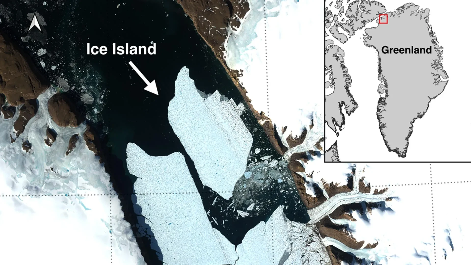
OTTAWA, ONTARIO — In a dramatic illustration of the accelerating transformations reshaping the Earth’s cryosphere, an international coalition of glaciologists has documented a catastrophic calving event at the Petermann Glacier in northwest Greenland. On August 4, 2026, the glacier relinquished a staggering 76.4-square-kilometer tabular ice island into the icy waters of the Nares Strait.
This monumental fracture marks the glacier’s most significant loss of floating ice since 2012 and stands as the largest single Arctic calving event recorded since 2020. The newly liberated monolith, boasting a thickness of up to 150 meters, commands a surface area roughly equivalent to that of Manhattan Island. For polar scientists, this spectacular rupture provides a vital, real-world laboratory to examine how massive Arctic ice masses generate, navigate regional marine currents, and ultimately disintegrate in a warming world.
The discovery was brought to light by Adam Garbo, a PhD student in glaciology at the University of Ottawa’s (uOttawa) Department of Geography, Environment and Geomatics. Garbo’s sharp-eyed satellite surveillance forms part of a robust, multi-institutional research initiative uniting uOttawa, the University of Stirling, Environment and Climate Change Canada (ECCC), Lancaster University, and the University of Leeds.
As the international scientific community absorbs the gravity of the event, researchers warn that this is far from an isolated occurrence. Advanced satellite monitoring indicates that Petermann’s remaining floating ice tongue is under severe mechanical stress, with further massive fractures poised to alter the topography of northwest Greenland in the near future.
Main Facts: Anatomy of a Polar Titan
To comprehend the scale of the August 4 event, one must examine the physical dimensions and geographic context of the Petermann Glacier. Located in northwest Greenland, Petermann is home to one of the island’s last remaining major floating ice tongues—a tongue that acts as a stabilizing brake against the accelerated flow of inland ice sheets.
The newly formed ice island measures 76.4 square kilometers and reaches a staggering thickness of 150 meters. To contextualize its sheer volume:
- Surface Area Comparison: Roughly equal to the entire borough of Manhattan in New York City.
- Historical Significance: The largest ice loss for Petermann Glacier since its historic 2012 calving, and the largest Arctic calving event overall since 2020.
- Geographic Placement: The ice mass broke away cleanly from the eastern side of the glacier’s floating ice tongue, directly into the fjord systems connecting to the Nares Strait, which separates Greenland from Ellesmere Island.
Unlike the jagged, chaotic icebergs frequently calved from tidewater glaciers in other regions, Petermann’s offspring is a tabular iceberg. Characterized by vertical cliffs and a flat, horizontal top, tabular icebergs form when expansive sheets of ice push out over the ocean while remaining afloat, eventually snapping off under immense structural strain. While common in the Southern Ocean around Antarctica, such pristine, monolithic ice islands are decidedly rare in the Arctic, elevating the scientific value of this event.
Chronology of a Collapse: Years of Growing Instability
The suddenness of the August 4 event belies a long, meticulously documented history of structural degradation. Scientists have maintained an uninterrupted vigil over the Petermann Glacier using high-resolution satellite observations since 2019, tracking the slow-motion unraveling of the ice tongue.
The Timeline of Failure
- 2019–2023 (The Incubation Phase): Researchers using long-term satellite telemetry began noting the steady, progressive widening of deep surface fractures—known as rifts—cutting perpendicularly across the central axis of Petermann’s floating ice tongue. These fractures acted as structural fault lines, slowly compromising the tensile strength of the ice.
- Late July 2026 (The Tipping Point): Continuous monitoring revealed accelerated widening along the primary fracture lines. The stress imposed by ocean swells, warming subsurface waters, and the relentless outward creep of the glacier pushed the ice past its mechanical threshold.
- August 3, 2026 (The Warning Signs): Radar and optical images captured by the European Space Agency’s (ESA) Sentinel-1 satellite mission flashed unmistakable signs of terminal deterioration. A clear line of separation began manifesting visibly along the centerline of the ice tongue, indicating that a catastrophic break was imminent.
- August 4, 2026, 20:00 UTC (The Rupture): Data synchronization and satellite telemetry confirmed that the fracturing process had reached completion. By 20:00 UTC, the 76.4-square-kilometer ice island had completely sheared away from the glacier’s eastern flank, drifting freely into the fjord.
"Petermann Glacier has long stood as one of Greenland’s largest remaining ice tongues," reflects Adam Garbo, who first identified the breakup. "We’ve anticipated this specific break for years, monitoring the rifts as they crept across the ice. Actually seeing it finally happen in real-time is both remarkable and deeply sobering."
Supporting Data and Future Projections
The August 4 calving event, while monumental, is merely a chapter in a rapidly accelerating narrative of glacial retreat. Predictive modeling and ongoing satellite surveillance suggest that Petermann Glacier’s structural integrity will face even greater tests in the immediate future.
The Looming Threat: Additional Disintegrations
According to glaciological assessments tied to the uOttawa-led collaboration, two additional massive sections of Petermann’s floating ice tongue are displaying advanced signs of structural failure. Rifts cutting through these zones have spent years propagating across the ice, and glaciologists project they will detach shortly.
- Projected Ice Island Alpha: Estimated at approximately 94 square kilometers.
- Projected Ice Island Beta: Estimated at approximately 84 square kilometers.
If both of these anticipated calving events materialize as projected, the combined impact of the three events will strip roughly 254 square kilometers away from Petermann Glacier’s floating ice tongue. This cumulative loss would diminish the total area of the ice tongue by an estimated 22 percent, permanently altering the physical geography of the region and reducing the mechanical backpressure holding back the inland ice sheets.
Furthermore, scientists emphasize that lessons learned from tracking Arctic ice islands have broad implications. "While large, tabular icebergs are relatively standard fare in the Southern Ocean surrounding the Antarctic Ice Sheet, Arctic ice islands are far rarer," notes Dr. Anna Crawford of the University of Stirling. "By studying how these rare Arctic structures behave, fracture, and melt, we gain vital knowledge that can be transferred across polar regions globally, improving our predictive models for sea-level rise."
Official Responses and Scientific Collaboration
The discovery of the Manhattan-sized ice island has galvanized an international network of researchers and governmental agencies, highlighting the crucial role of cross-border scientific cooperation in monitoring planetary shifts.
The discovery itself is the fruit of an ongoing partnership involving:
- The University of Ottawa (Canada) – Leading the glaciological analysis and satellite tracking.
- The University of Stirling (United Kingdom) – Contributing expertise in polar dynamics and ice island mechanics.
- Environment and Climate Change Canada (ECCC) – Providing operational monitoring for marine safety.
- Lancaster University (United Kingdom) – Supporting ice-ocean interaction studies.
- The University of Leeds (United Kingdom) – Offering advanced geodetic and satellite remote-sensing capabilities.
This collaborative framework ensures that observational data flows seamlessly from academic research centers to operational forecasting agencies tasked with safeguarding human life and economic infrastructure in the Arctic.
Implications: Marine Hazards and Global Climate Dynamics
While the primary conversation surrounding events like the Petermann calving often centers on climate change and glaciology, the immediate operational implications are starkly practical: maritime safety and shipping security.
Navigational Hazards in Polar Waters
Massive pieces of floating ice do not simply vanish upon calving. Because of their immense thickness—in this case, up to 150 meters—they possess deep draughts, meaning the vast majority of their mass sits below the waterline, subjecting them to deep ocean currents rather than surface winds alone. These ice islands can remain structurally intact for years as they slowly drift through Arctic channels.
Over time, however, wave action, thermal erosion, and internal stresses cause them to fracture into smaller, unpredictable icebergs and growlers. These fragments are notoriously difficult to track via standard radar and visual observation, presenting acute hazards to commercial vessels, research ships, and offshore resource operations traversing Arctic shipping routes.
Recognizing these risks, Environment and Climate Change Canada has mobilized its resources. Building on protocols established during previous Arctic ice shelf calving events, the Canadian Ice Service is actively tracking the trajectory of the newly liberated Petermann ice island.
"These are immensely thick blocks of ice that possess the capability to drift through polar waters for years," specifies Dr. Abigail Dalton of the Canadian Ice Service, ECCC. "Over prolonged periods, they inevitably fracture into smaller, harder-to-track pieces. These rogue fragments pose significant, lingering hazards to marine vessels and offshore resource operations venturing into northern waters."
The Road Ahead
For Adam Garbo and his international collaborators, the immediate task involves relentless surveillance. Utilizing a combination of high-resolution satellite imagery, airborne observations, and oceanographic tracking data, the research team aims to follow the ice island’s life cycle from birth to eventual melt in the North Atlantic.
Ultimately, this event serves as a stark reminder of the dynamic, often volatile nature of the High Arctic. As warming atmospheric and oceanic temperatures continue to exert pressure on Greenland’s ancient ice structures, events like the Petermann Glacier fracture transition from scientific curiosities into critical indicators of a rapidly changing global climate system.
