

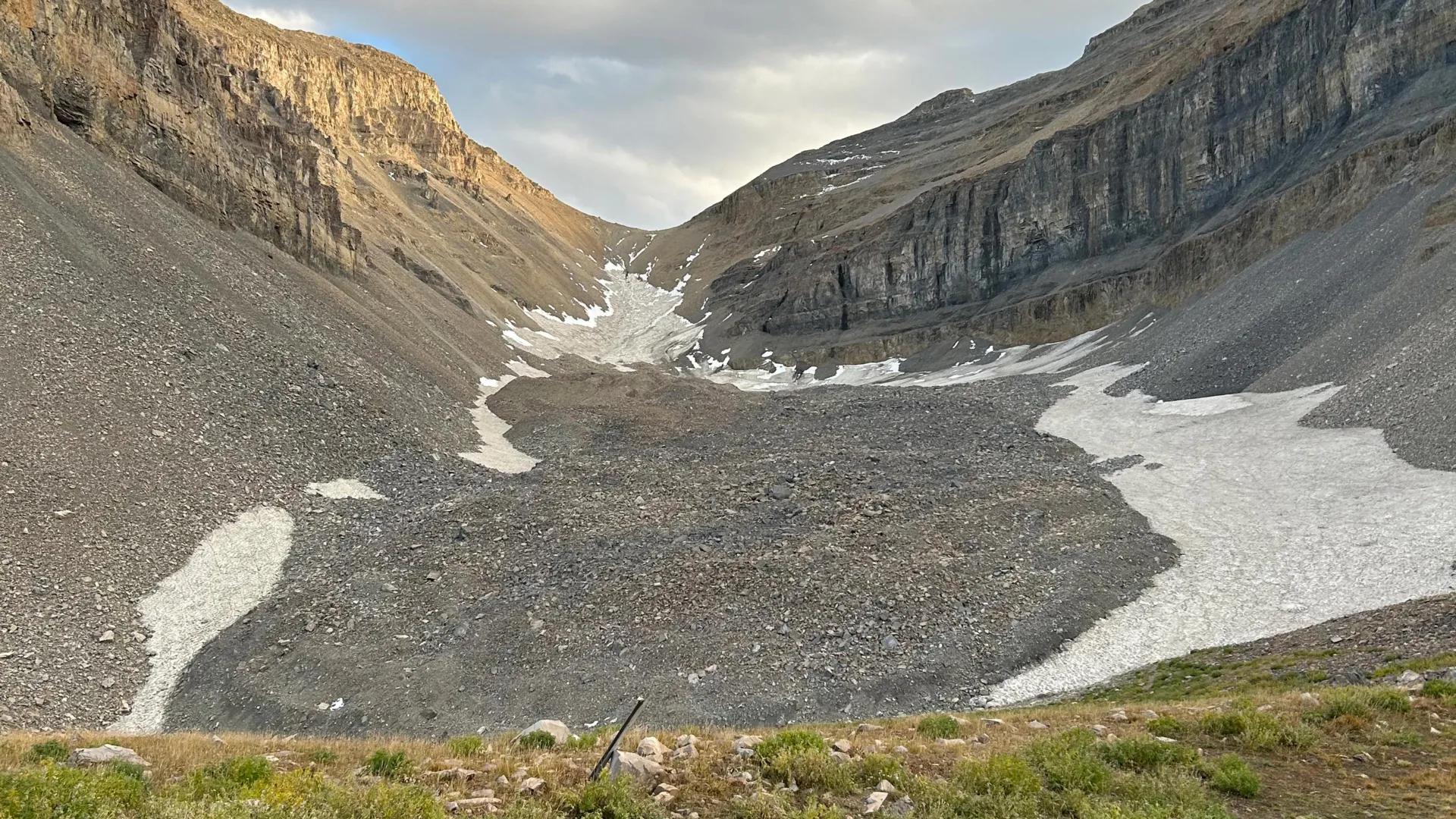
SALT LAKE CITY — To the casual hiker trekking high into Utah’s majestic Wasatch and Uinta ranges, the terrain can appear aggressively arid, defined by endless, chaotic expanses of grey boulders, talus slopes, and loose scree. These sprawling fields of broken rock look entirely dead, devoid of the classic, brilliant blue-white ice tongues that define conventional alpine glaciers in places like Alaska, the Swiss Alps, or the rugged peaks of Patagonia.
Yet, beneath these seemingly barren blankets of stone lies a staggering hydrological secret.
In a pair of groundbreaking recent studies, a team of geologists and geophysicists at the University of Utah has peered deep beneath the stony exterior of one of the state’s most prominent geological formations: the Timpanogos Rock Glacier, situated directly beneath the formidable summit of Mount Timpanogos between Salt Lake City and Provo. Utilizing a high-precision, physics-defying approach that measures microscopic fluctuations in Earth’s gravity, the researchers have done what was previously thought nearly impossible. They have generated a high-resolution, three-dimensional digital image of the hidden ice locked away inside the rock glacier, revealing that the formation is astonishingly ice-rich.
The findings upend traditional understandings of alpine water storage in the Intermountain West. According to the research, the Timpanogos Rock Glacier alone holds roughly 1.5 million cubic meters of frozen water—a volume roughly equivalent to 600 Olympic-sized swimming pools, or the massive bulk of the Great Pyramid of Giza in Egypt.
"When we are high in the mountains and walking across loose rocks or rubble, you don’t realize there could be 120 feet of ice buried beneath your feet," says Leif Anderson, a glaciologist and co-author of the research.
As the American West confronts persistent megadroughts, a rapidly warming climate, and dwindling snowpacks, these subterranean glaciers are emerging as critical, albeit fragile, underground water towers.
Main Facts at a Glance
- The Discovery: University of Utah researchers successfully mapped the internal structure of the Timpanogos Rock Glacier using a novel combination of precision gravimetry and advanced Bayesian statistical modeling.
- Ice Content: The Timpanogos Rock Glacier is composed of approximately 83% ice and only 17% loose rock, containing an estimated 1.5 million cubic meters of frozen water.
- Global and State Significance: Utah is home to 836 identified rock glaciers. Across the globe, an estimated 50,000 such formations may collectively store roughly 48 gigatons of water. Within Utah alone, rock glaciers may harbor upwards of 1 gigaton (815,000 acre-feet) of water.
- Origins: Unlike ancient Ice Age formations, these rock glaciers are dynamic systems that formed after the peak of the last Ice Age, continually fed and insulated by ongoing rockfalls that bury and protect persistent mountain snowpacks.
Chronology of the Research: From Fieldwork to Breakthrough Imaging
The road to uncovering the secrets of Mount Timpanogos required a meticulous blending of rugged alpine fieldwork and heavy computational data processing spanning several years.
The 2023 Foundation: Understanding Accumulation
The first piece of the puzzle began to take shape during the summer of 2023, when Isaiah Davies, an undergraduate student at Stanford University working as a visiting summer researcher at the University of Utah, spearheaded an initial investigation into how these strange formations actually grow and maintain themselves.
Working alongside faculty mentors, Davies focused on the mechanics of mass addition. Their findings, published on April 2, 2026, in Geophysical Research Letters, challenged the assumption that rock glaciers are merely stagnant relics of a bygone era. Instead, the team discovered that headwall erosion—the continuous crumbling and weathering of the steep cliffs above—plays a vital role. In the Wasatch Mountains, falling debris repeatedly crashes down onto persistent snowfields nestled in high-altitude cirques. This tumbling rock blankets the snow, insulating it from summer solar radiation and atmospheric heat, effectively trapping it beneath thick layers of rubble and initiating the slow, creeping transformation into a rock glacier.
The Fall 2024 Gravimeter Campaign
Building upon these dynamics, former University of Utah Department of Geology & Geophysics graduate student Bronson Cvijanovich took the lead in the field during the autumn of 2024. Cvijanovich organized and executed a grueling series of high-altitude field expeditions to the Timpanogos Rock Glacier, hauling sensitive scientific equipment up steep terrain to the stretches of ice sitting just above Emerald Lake.
Armed with a state-of-the-art gravimeter—an instrument sensitive enough to detect minute variances in Earth’s gravitational acceleration—Cvijanovich methodically mapped the surface. Over six separate field trips, he recorded gravity measurements at 232 precise locations laid out in a strict grid across the glacier, with each data point spaced roughly 25 meters (80 feet) apart.
The 2025–2026 Computational Phase
Once the field data was secured, the project shifted from the alpine heights to the computer lab. Raw gravity measurements alone cannot paint a picture of what lies underground; the researchers had to meticulously filter out environmental "noise." This included accounting for micro-variations caused by Earth’s tides, the shifting positions of the sun and moon, and local nuances in surface topography, elevation, and latitude.
Once the data was cleaned, lead author Cvijanovich, alongside geophysics professor Michael Thorne and glaciologist Leif Anderson, implemented a novel mathematical framework utilizing Bayesian statistics.
"We spent months of computation time doing the imaging with our new techniques," Thorne explains. By leveraging the stark density contrast between the heavy, solid rock of Mount Timpanogos and the significantly lighter, low-density ice tucked within the adjacent glacier, the team was able to invert the gravity data. The resulting 3D models provided a subterranean look at the glacier’s thickness and internal architecture, bypassing the limitations of satellite imagery, which can only map a rock glacier’s two-dimensional surface footprint.
The culminating paper detailing this methodology, titled "The internal ice content of Timpanogos Rock Glacier, Utah, USA from 3-D Bayesian inversion of gravity data," was published on August 26 in the Journal of Geophysical Research.
Supporting Data and Scientific Insights
To understand the magnitude of these findings, one must first grasp the physical mechanics of what a rock glacier is. Unlike standard glaciers, which feature rivers of exposed blue ice flowing under their own immense weight down a mountain valley, rock glaciers are heavily armored. They are essentially periglacial landforms where a core of massive, consolidated ice is sealed away beneath a protective mantle of rocky debris, protecting the frozen reservoir from melting away during scorching summer months.
Density Dynamics
The gravimeter operated on a simple yet powerful physical principle: mass creates gravity. The dense limestone and quartzite comprising the peak of Mount Timpanogos exert a stronger gravitational pull than the lighter ice hidden within the glacier.
When Cvijanovich’s gravimeter traversed areas where the buried ice sheet was thickest, the instruments recorded a distinct, measurable decrease in gravitational acceleration. By feeding these gravitational signatures into their Bayesian inversion models, the researchers could calculate the depth of the rock-ice boundary with unprecedented accuracy.
Demolishing the "Ice Age Relic" Hypothesis
For decades, many geomorphologists assumed that rock glaciers in the interior western United States were stagnant, fossilized leftovers from the Last Glacial Maximum, which peaked roughly 18,000 to 21,000 years ago.
However, the University of Utah studies indicate otherwise. The mathematical growth models developed by the team show that these formations are actively evolving systems. They did not simply survive the end of the Ice Age; rather, they are dynamic reservoirs that accumulated and expanded during the climatic fluctuations of the Holocene epoch—the thousands of years following the retreat of the major Ice Age valley glaciers.
As cliff faces continue to erode and shed rubble over modern snow accumulations, these underground glaciers continually regenerate.
Official Responses and Expert Perspectives
The implications of these studies have resonated deeply across the academic and geological communities, drawing praise for their innovative use of geophysical imaging techniques.
"Timpanogos Rock Glacier is surprisingly ice rich. It is 83% ice and 17% loose rock,"
— Bronson Cvijanovich, lead author and former University of Utah geology graduate student.
The discovery highlights a hidden dimension of alpine hydrology that has historically been ignored or poorly quantified in regional water models. While state water resource managers have long tracked snowpack via SNOTEL sites and monitored surface reservoirs like the Great Salt Lake, Flaming Gorge, and Lake Powell, subterranean ice reserves have remained a wild card.
"There’s a lot of ice that’s hidden in Utah’s mountains,"
— Leif Anderson, co-author and glaciology professor.
Anderson emphasizes that as temperatures in the American West continue to climb, understanding these cold-core debris-covered systems is no longer an academic exercise—it is an environmental necessity.
Co-author Michael Thorne underscores the computational triumph of the research, noting that the success of the gravity-inversion technique opens up new avenues for exploring similar geological formations worldwide without resorting to destructive drilling operations.
"There is a large contrast in mass density between the rock that makes up Mount Timpanogos and the much lower density ice that is in rock glacier adjacent to it… When we measure the gravitational acceleration over the rock glacier, we see a larger decrease in that gravitational acceleration as we make measurements over areas with thicker ice,"
— Michael Thorne, geophysics professor.
Broader Implications: A Massive Mountain Water Reserve
The methodologies perfected on Mount Timpanogos allowed the researchers to scale up their perspective, transforming a localized study into a global ecological assessment.
Scaling Up to the State and Planet
Satellite inventories have cataloged approximately 836 individual rock glaciers scattered across various mountain ranges in Utah, including the Wasatch, the Uintas, and the La Sal Mountains on the Colorado Plateau near Moab.
By establishing a direct mathematical scaling relationship between a rock glacier’s surface area and its underlying ice volume based on the Timpanogos data, the team projected total water storage across the state and the globe.
- Utah Reserves: Statewide, Utah’s rock glaciers collectively harbor an estimated 1 gigaton of water, equating to roughly 815,000 acre-feet of frozen fresh water—enough to supply municipal and agricultural needs for significant portions of the population during dry cycles.
- Global Reserves: Applying the model internationally, the team estimates that the approximately 50,000 documented rock glaciers across the globe contain a staggering 48 gigatons of water. To put that in perspective, one gigaton equals one billion metric tons (or one cubic kilometer of water), which is enough to fill roughly 400,000 Olympic swimming pools.
Climate Vulnerability and Future Outlook
Despite their protective rock armor, rock glaciers are not entirely immune to anthropogenic climate change. As atmospheric temperatures rise, the thermal wave eventually penetrates the outer layer of loose rock, threatening the stability of the ice cores within. When rock glaciers begin to thaw, they can release massive pulses of cold water into high-altitude headwater streams, altering aquatic ecosystems and eventually depleting a vital, long-term dry-season water source.
Yet, because the debris mantle acts as a highly effective thermal insulator, rock glaciers melt much slower than their exposed, conventional glacier counterparts. This slow-release mechanism makes them crucial buffering agents against severe droughts, steadily feeding high-mountain streams long after the winter snowpack has completely vanished.
As water scarcity intensifies throughout the American Southwest, the University of Utah’s mapping of the Timpanogos Rock Glacier provides a vital framework for future water resource management. By proving that millions of cubic meters of pristine water are hidden in plain sight beneath hikers’ boots, the research illuminates a path toward better understanding, protecting, and accounting for the West’s hidden subterranean reservoirs.
Funding and Acknowledgments
The comprehensive research projects were made possible through generous financial support and institutional backing from key scientific organizations, including:
- The U.S. Geological Survey (USGS)
- The National Science Foundation (NSF)
- The University of Utah’s Wilkes Center for Climate Science & Policy
- The University of Utah’s Office of Undergraduate Research
- The Summer Program for Undergraduate Research (SPUR)
