

SOUTHAMPTON, UK — For generations, visitors standing at the rim of the Grand Canyon have gazed down into a dizzying chasm of sculpted rock, marveling at the sheer might of the Colorado River. Schoolchildren are taught that this majestic gash in the Earth’s crust is the handiwork of relentless water and time, carved systematically over millions of years through the arid landscape of northern Arizona.
Yet, a groundbreaking international study published in the journal Geology reveals that the true architects of the Grand Canyon’s deepest secrets may have begun their work nearly a billion years before the first drops of the Colorado River ever touched the stone.
Led by an interdisciplinary team of researchers at the University of Southampton in the UK—in collaboration with the GFZ Helmholtz Centre for Geosciences and the University of Potsdam in Germany, as well as the University of Illinois Urbana-Champaign in the USA—the study rewrites the early history of North America. Scientists have uncovered compelling evidence that an enormous ancient cliff system, or "great escarpment," once towered over western North America, systematically unearthing the continent’s crystalline basement rocks long before modern topography ever took shape.
This revelation does more than shift the timeline of a national treasure; it offers a compelling, long-sought solution to one of geology’s most vexing puzzles: the Great Unconformity.
Main Facts: The Discovery of the Great Escarpment
At the core of the new scientific consensus is a dramatic tectonic restructuring of the ancient past. Approximately 800 million years ago, the Earth was home to a primordial supercontinent known as Rodinia. As internal planetary forces tore Rodinia apart, the violent fragmentation unleashed a cascade of geological events across the globe.
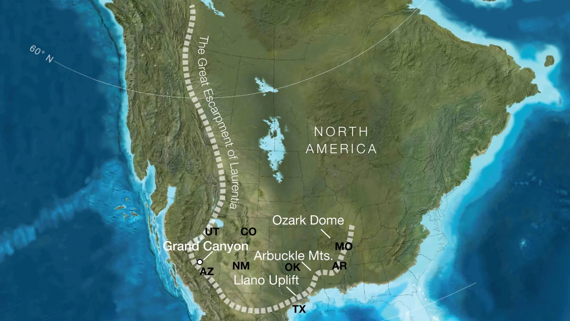
According to the new research, the rupture of the supercontinent birthed a colossal geographical feature: a towering "great escarpment" that stretched for thousands of kilometers along the western margin of ancient North America (known scientifically as Laurentia). These precipitous cliffs reached heights of roughly one kilometer (about 3,280 feet), creating a massive, jagged topographical barrier.
Over tens of millions of years, aggressive weathering and erosion battered this immense rocky boundary. This persistent natural grinding removed staggering amounts of overlying material, eventually exposing ancient, crystalline basement rocks that now form the lower depths of the modern Grand Canyon.
Rather than a simple story of a river cutting down through horizontal strata, the research highlights a complex, multi-stage evolutionary history. The Grand Canyon preserves a geological record stretching back roughly two billion years—yet more than half of that rock record appears to be conspicuously absent. This missing chapter has baffled geologists for generations. The Southampton-led study proposes that the Canyon’s basement rocks were progressively brought to the surface not by the Colorado River, but as part of this immense, migrating escarpment created during the breakup of Rodinia.
Chronology: A Billion-Year Timeline of Earth’s Evolution
To fully appreciate the magnitude of this discovery, geologists must look backward across a vast expanse of deep time, tracing a sequence of events that spans over a billion years:
1. The Pre-Rodinia Foundation (2 Billion to 1 Billion Years Ago)
Long before complex life populated the planet, the basement rocks that now line the base of the Grand Canyon were formed deep within the Earth’s crust through intense metamorphic and magmatic processes. These foundational crystalline rocks sat buried deep beneath layers of younger sediment.
2. The Fragmentation of Rodinia (Circa 800 Million Years Ago)
As tectonic forces ripped the supercontinent Rodinia asunder, continental rifting caused massive swaths of the Earth’s crust to uplift. Along the margins of the fracturing landmass, colossal fault blocks tilted and warped, giving rise to the Great Escarpment—a system of towering cliffs roughly a kilometer high.
3. The Great Retreat and Massive Erosion (750 Million to 500 Million Years Ago)
As the escarpment was battered by ancient weather systems, it began to retreat inland. This was not a localized phenomenon; the researchers propose this ancient escarpment crossed a vast geographic footprint that today encompasses portions of modern-day Arizona, Utah, Idaho, Wyoming, Colorado, Texas, Oklahoma, Arkansas, Missouri, and Illinois. As the giant cliff system migrated, it shaved off between five and ten kilometers of overlying rock in various regions, dumping vast quantities of sediment into adjacent basins.
4. The Rise of the Modern Landscape (Past 6 Million Years)
Fast-forwarding through hundreds of millions of years of relative stability, shallow inland seas advanced and retreated across the continent. Eventually, relatively recently in geological terms—roughly six million years ago—the Colorado River seized upon pre-existing zones of weakness to begin carving the modern Grand Canyon we recognize today, utilizing the ancient stage set by Rodinia’s breakup.
Supporting Data: Reconstructing a Lost North American Landscape
Reconstructing a landscape that vanished hundreds of millions of years ago requires an intricate blend of high-tech modeling and rigorous fieldwork. To peer into this deep-time window, the research team combined sophisticated reconstructions of plate tectonic movements with modern data models demonstrating how landscapes evolve, erode, and migrate over geological timescales.
The team’s simulations yielded a striking realization: when Rodinia was fragmenting, the geographic region that would one day become the Grand Canyon occupied roughly the same tectonic position relative to the continental edge as major, active escarpments found today in places like South Africa and Brazil.
By analyzing the physics of escarpment retreat—a process whereby steep cliff faces gradually migrate inland as their bases are eroded—the researchers estimated that this ancient North American barrier could have removed as much as eight kilometers (nearly five miles) of rock in certain locations.
Crucially, this theoretical prediction matches independent empirical data gathered across the American Southwest. Decades of geological observations have long indicated that roughly five to ten kilometers of rock mysteriously disappeared from parts of the region long before the modern Grand Canyon began to form. Until now, scientists lacked a unified mechanical explanation for how such an immense volume of rock could be stripped away so uniformly across such a massive area. The Great Escarpment model neatly bridges this empirical gap.
Official Responses: Insights from the Lead Researchers
The implications of the study extend far beyond the borders of Arizona, offering a fresh lens through which geologists can view continental interiors globally.
Professor Thomas Gernon of the University of Southampton, the lead author of the study, emphasized how the research untangles long-standing geological mysteries.
"Our paper suggests the Canyon’s basement rocks were progressively brought to the surface as part of an immense escarpment that developed during the breakup of an ancient supercontinent," Prof. Gernon explained. "The findings also shed light on the formation of the Great Unconformity, a mysterious gap in the rock record that spans over a billion years."
The Great Unconformity is one of geology’s most famous enigmas. In many locations around the world—most visibly in the Grand Canyon—relatively young sedimentary layers (around 520 million years old) sit directly atop ancient, highly deformed crystalline rocks (roughly 1.7 to 2 billion years old). The intervening billion years of history are simply missing, as if pages were ripped straight out of a historical manuscript.
Prof. Gernon noted that the newly discovered tectonic landscape provides the missing puzzle piece for understanding this anomaly:
"This long-lived tectonic landscape provides a missing piece in understanding why erosion associated with the Great Unconformity varies so dramatically across the southwestern US. Our work suggests that tectonic uplift related to continental rifting and breakup created both steep slopes and high ground, providing the mountainous terrain that rivers and glaciers could readily erode."
By drawing parallels to modern Earth, the research team validated their computer models using observable, active geographies.
"Today’s escarpments in Africa, Brazil, India and Antarctica provide windows into the forces that shape continents over hundreds of millions of years," Prof. Gernon added. "By comparing Grand Canyon’s ancient history with active landscapes like the Great Escarpment of South Africa, we’re able to see North America’s most iconic geologic landmark in an entirely new light."
Implications: Reshaping North America and Global Geology
The cascading effects of this ancient escarpment would have radically altered the face of primeval North America, setting the stage for the biological and ecological developments that followed.
Shaping Rivers, Sediments, and the Rise of Complex Life
By maintaining a long-lived mountainous rim around western Laurentia—the ancient continental core—the escarpment acted as a master regulator of Earth’s surface processes. It dictated the pathways that ancient rivers could travel, determined precisely where eroded sediments accumulated in marine basins, and influenced the timing and geographic spread of rising seas across the continent.
These massive geographical shifts occurred immediately prior to the Cambrian explosion—a pivotal epoch in Earth’s history approximately 541 million years ago when complex, multicellular animal life diversified at an unprecedented rate. While scientists are still exploring the direct correlations, major environmental and topographical changes of this scale inevitably played a role in altering nutrient fluxes into the oceans, potentially catalyzing ecological revolutions.
A New Paradigm for Global Geology
Beyond North America, the study’s findings hold profound implications for geologists working across the globe. Many continental interiors feature massive, unexplained gaps in their rock records similar to the Great Unconformity.
By demonstrating that continental rifting and the subsequent migration of ancient escarpments can quietly shave off miles of rock over hundreds of millions of years, the Southampton-led study offers a new diagnostic tool for Earth scientists. Researchers can now apply these models to reinterpret enigmatic unconformities on other continents, gaining a more holistic, unified understanding of how Earth’s crust has fractured, healed, and transformed throughout deep time.
Ultimately, the towering red walls of the Grand Canyon remain as breathtaking as ever. But thanks to this new research, looking down into its dizzying depths is no longer just an encounter with the power of a river. It is a portal to an ancient, lost world—a time when a titanic mountain rim tore across a splintering supercontinent, laying bare the primordial bones of the North American continent.
