

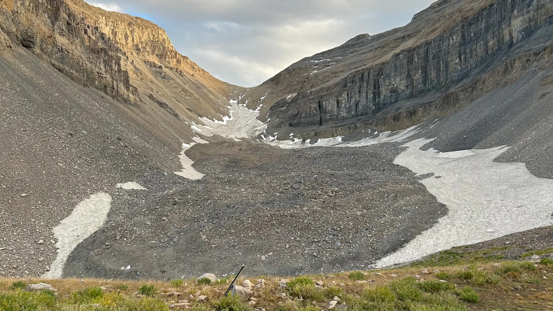
To the casual hiker traversing the rugged, boulder-strewn terrain of Utah’s Wasatch and Uinta ranges, the landscape appears as a chaotic jumble of weathered stone and loose rubble. These sprawling fields of debris, known as rock glaciers, look entirely distinct from conventional, blue-ice alpine glaciers. They lack the gleaming, exposed surface rivers and crevasses traditionally associated with glacial ice. Instead, they present a dry, inhospitable facade of gray rock.
Beneath that deceptively barren surface, however, lies a staggering environmental secret.
A team of geologists and geophysicists at the University of Utah has taken an unprecedented, high-resolution look inside one of the state’s most prominent geological formations: the Timpanogos Rock Glacier, nestled beneath the towering, jagged summit of Mount Timpanogos between Salt Lake City and Provo. In two landmark studies, the research team has unraveled the mystery of how these hidden ice masses form and calculated, with astonishing precision, just how much water is locked away beneath the stones.
By measuring imperceptible fluctuations in Earth’s gravitational pull, the scientists have developed a pioneering 3D imaging technique. Their findings reveal that the Timpanogos Rock Glacier is remarkably ice-rich—composed of 83% frozen water and only 17% loose rock. In total, this single subterranean reservoir houses roughly 1.5 million cubic meters of frozen water, a volume roughly equivalent to 600 Olympic-sized swimming pools or the colossal Great Pyramid of Giza in Egypt.
Chronology of Discovery: From Fieldwork to Gravimetric Imaging
The breakthrough research is the culmination of years of rigorous field campaigns, advanced mathematical modeling, and months of intensive computational analysis.
The 2023 Summer Foundation
The groundwork for understanding the mechanics of these formations began in earnest during the summer of 2023. Isaiah Davies, an undergraduate student at Stanford University working as a visiting summer researcher at the University of Utah, stepped into the role of lead author on the team’s first major inquiry. Collaborating with department faculty, Davies focused on the developmental origins of Utah’s rock glaciers—specifically addressing how these formations originate and maintain their mass in a warming climate.
The Fall 2024 Gravity Campaign
Building upon those theoretical models, the research shifted from conceptual physics to hands-on geophysics in the fall of 2024. Bronson Cvijanovich, then a graduate student in the University of Utah’s Department of Geology & Geophysics, led a series of arduous field expeditions high above Emerald Lake to the surface of the Timpanogos Rock Glacier.
Hauling sensitive, state-of-the-art geophysical equipment across shifting piles of unstable rock, Cvijanovich executed six distinct field excursions. Across the treacherous terrain, he gathered precision gravity measurements at 232 carefully mapped locations, organized in a rigid grid where each point was separated by roughly 25 meters (about 80 feet).
Computational Breakthroughs (2025–2026)
Once the field data was secured, the challenge shifted from the mountain slopes to the supercomputers. The raw gravity measurements required exhaustive normalization to account for environmental variables, including minute gravitational distortions caused by the shifting positions of the sun and moon, as well as localized differences in surface topography, latitude, and elevation.
Utilizing advanced Bayesian statistics, the research team engineered an entirely novel mathematical inversion method to construct a three-dimensional model of the glacier’s internal architecture. According to co-author and geophysics professor Michael Thorne, the team dedicated months of continuous computational processing power to successfully render the hidden ice in high-resolution 3D.
The culmination of this exhaustive timeline arrived in two distinct publications. The first study, examining rock glacier formation and headwall erosion, was published on April 2, 2026, in Geophysical Research Letters. The definitive structural analysis—detailing the 3D Bayesian inversion of the gravity data—was published on August 26, 2026, in the prestigious Journal of Geophysical Research.
Supporting Data: Decoding the Subsurface Through Gravity
Understanding the interior of a rock glacier has historically presented an immense challenge to glaciologists. While satellite imagery can easily map a rock glacier’s surface footprint, it offers virtually no insight into its depth, structural integrity, or volumetric ice content. To pierce through tens of feet of protective debris, researchers needed a mechanism analogous to a medical CT scan—something capable of revealing internal tissues beneath an opaque exterior.
The solution lay in gravimetry. A gravimeter measures the local acceleration of gravity with extreme sensitivity. Because solid mountain rock is significantly denser than frozen water, a distinct mass-density contrast exists between the host mountain and the interior of the adjacent rock glacier.
As lead researcher Bronson Cvijanovich and his colleagues collected data across their 232-point grid, the gravimeter registered subtle decreases in gravitational acceleration whenever the instrument passed over areas with thicker subterranean ice deposits.
+--------------------------------------------------------------------------+
|                        TIMPANOGOS ROCK GLACIER                           |
|                  (Compositional Breakdown by Volume)                     |
|                                                                          |
|   [████████████████████████████████████████████████████████████ ] 83% Ice|
|   [███████████                                                  ] 17% Rock|
|                                                                          |
|   Total Frozen Water: ~1.5 Million Cubic Meters                          |
|   Equivalency: 600 Olympic Swimming Pools / Great Pyramid of Giza        |
+--------------------------------------------------------------------------+
"There’s a lot of ice that’s hidden in Utah’s mountains," said glaciology professor Leif Anderson, who oversaw the research alongside Professor Michael Thorne. "When we are high in the mountains and walking across loose rocks or rubble, you don’t realize there could be 120 feet of ice buried beneath your feet."
Furthermore, the team’s mathematical modeling successfully challenged long-held assumptions regarding the age of these formations. Conventional wisdom often categorizes glacial features in the region as stagnant, melting remnants of the last Ice Age, which peaked between 21,000 and 18,000 years ago. However, the data reveals that Utah’s rock glaciers are dynamic, younger reservoirs. They developed continuously over the millennia after the major Pleistocene ice sheets retreated, sustained by unique local geological processes.
Official Perspectives and Expert Analysis
The implications of these studies stretch far beyond the borders of Utah, offering critical insights into hydrology, climate resilience, and alpine geomorphology.
Professor Leif Anderson explained the precise mechanism that allows these formations to thrive in the Wasatch Range, where lower elevations and warmer ambient temperatures might otherwise preclude permanent ice survival. According to Anderson, the dynamic erosion of steep mountain valleys plays a central protective role.
"In the Wasatch, the mountains themselves are eroding and burying the snow, and that’s why the rock glaciers exist," Anderson noted.
The team’s newly established mathematical models demonstrate that regular, recurring rockfalls cascade down steep headwalls, blanketing persistent snowpacks in upper glacial cirques. This protective overburden of stone acts as an effective thermal blanket, shielding the trapped snow and ice from direct solar radiation and warm summer air temperatures, thereby allowing massive ice bodies to persist for centuries or millennia.
Co-author Michael Thorne emphasized the technical achievement of the gravity-inversion methodology, noting that the fusion of field gravimetry and Bayesian statistics provides a powerful new toolkit for earth scientists. "When we measure the gravitational acceleration over the rock glacier, we see a larger decrease in that gravitational acceleration as we make measurements over areas with thicker ice," Thorne explained. By translating these density differentials into spatial models, the researchers have provided the scientific community with a non-destructive, highly accurate method for assessing alpine water storage globally.
Implications: A Vast, Uncharted Mountain Water Reserve
The discovery on Mount Timpanogos carries profound implications for water resource management in the American West and around the globe.
Timpanogos Rock Glacier is merely one of 836 officially cataloged rock glaciers identified across Utah via satellite reconnaissance. By establishing a direct, mathematical correlation between a rock glacier’s visible surface area and its hidden ice volume, the researchers were able to scale their findings outward.
When applied to the estimated 50,000 known rock glaciers scattered across mountain ranges worldwide, the implications are staggering. The research suggests that global rock glaciers collectively house approximately 48 gigatons of water. To put that figure in perspective, one gigaton is equivalent to one billion metric tons—or one cubic kilometer of water—which translates to enough liquid to fill 400,000 Olympic swimming pools.
Within the boundaries of Utah alone, these hidden stone-armored reserves may harbor roughly 1 gigaton of water, equating to approximately 815,000 acre-feet. For an arid state heavily reliant on seasonal snowpack runoff for municipal, agricultural, and industrial needs, recognizing rock glaciers as substantial, long-term freshwater reservoirs is a paradigm shift.
As climate change continues to alter traditional snow accumulation patterns and accelerate the melt rates of exposed alpine glaciers, these debris-covered ice masses may serve as critical, climate-buffered hydrological buffers. Because the thick mantles of surface rock insulate the ice from rapid thermal degradation, rock glaciers can slowly release water during extended drought years, sustaining mountain streams and downstream ecosystems when traditional surface supplies run dry.
The research projects were made possible through collaborative funding and institutional support from the U.S. Geological Survey, the National Science Foundation, the University of Utah’s Wilkes Center for Climate Science & Policy, the university’s Office of Undergraduate Research, and the Summer Program for Undergraduate Research.
As scientists continue to map and evaluate these hidden sub-surface reservoirs, Utah’s rugged peaks are revealing a vital, frozen legacy—one quietly locked away beneath the stones, waiting to sustain the watersheds of the future.
