

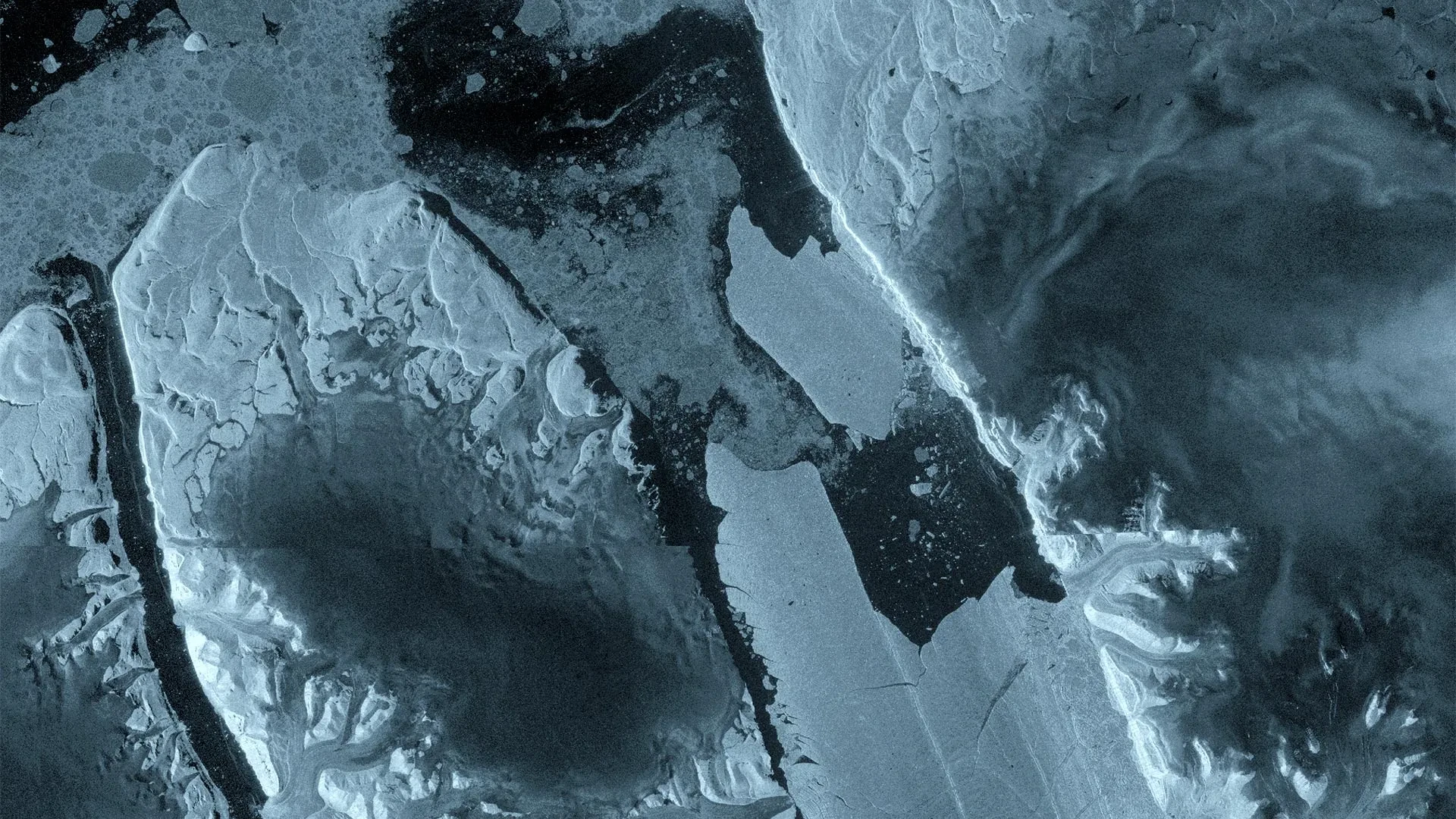
COPENHAGEN/OTTAWA — In what Earth scientists are calling a watershed moment for high-latitude observation, Europe’s Copernicus Sentinel-1 mission has documented a monumental fracture in the Arctic. On August 4, 2026, a staggering 76-square-kilometer section of the floating ice tongue of northwest Greenland’s Petermann Glacier broke away, creating a tabular iceberg roughly the size of Manhattan.
This historic calving event represents the largest loss of floating ice from the Petermann Glacier since 2012 and stands as the single biggest such event recorded across the entire Arctic region since 2020. Up to 150 meters thick, the newly formed "ice island" is drifting into the freezing waters of the far north, offering a stark, highly visible testament to the accelerating transformations reshaping Earth’s polar cryosphere.
The break is not merely an isolated geographic curiosity; it is the culmination of years of meticulous international tracking, advanced radar interferometry, and mounting stress within one of Greenland’s last remaining major ice tongues. As scientists race to understand the cascade of physical forces that triggered the collapse, the event has triggered urgent security warnings for Arctic shipping lanes, while opening an unprecedented window into the mechanics of glacial retreat.
Chronology of a Collapse: From Hidden Fractures to Open Ocean
The story of the August 2026 calving event is one written in microscopic shifts, recorded over months by orbiting satellites before erupting into a macro-scale structural failure in a matter of hours.
The Months Before: Silent Deformation
As early as April 2026, interferometric radar observations collected over the Petermann Glacier revealed deep-seated structural deformation and multiplying fractures hidden deep within the floating ice tongue. These high-resolution measurements gave researchers an extraordinary, microscopic view of internal strains developing months before any visible surface changes alerted the casual observer.
For years, an international research coalition—partially funded through the European Space Agency’s (ESA) FutureEO ARCTEX project—had tracked expanding rifts across the glacier. Comprising experts from the University of Ottawa in Canada, the Universities of Stirling, Lancaster, and Leeds in the UK, and the Canadian Ice Service of Environment and Climate Change Canada, the team had watched with mounting concern as the ice tongue’s structural integrity progressively degraded.
August 3–4: Rapid Unraveling
The final sequence of the breakup unfolded at a blistering pace. On August 3, 2026, routine radar images captured by the Sentinel-1 satellite revealed significant, accelerated deterioration developing right along the center of the glacier’s massive ice tongue. The internal rifts, long monitored via radar, were coalescing into critical stress lines.
Just 24 hours later, on August 4, the tipping point was reached. The massive tabular iceberg fully separated from the glacier’s eastern flank, cleanly shearing away and embarking on its journey as an independent ice island.
According to glaciologists tracking the region, the event marks a dramatic shift for the Petermann Glacier. While the glacier produced notable mega-icebergs in 2008, 2010, and 2012, it had remained remarkably stable in the intervening decade and a half, enduring only minor, routine calving episodes. The August 2026 break shatters that period of relative calm and signals that the glacier may have entered a new, highly volatile phase of sustained retreat.
Supporting Data and Technological Triumph: The Sentinel-1 Advantage
The ability of scientists to capture this massive event down to the day—and in some cases, near-real time—highlights a revolution in Earth observation capabilities, driven largely by the European Union’s Copernicus program and the radar wizardry of the Sentinel-1 mission.
Seeing Through the Dark and Clouds
Monitoring remote polar regions has historically been plagued by severe logistical hurdles. The Arctic is frequently shrouded in heavy cloud cover, and experiences months of polar darkness during which optical satellites are effectively blind.
Sentinel-1 overcomes these barriers through active synthetic aperture radar (SAR) imaging. By bouncing microwave signals off the Earth’s surface and measuring the return echoes, Sentinel-1 can pierce through clouds, fog, and perpetual darkness alike, delivering crystal-clear structural data day and night.
The Tandem Phase Advantage
The unprecedented detail of the August 2026 breakup was made possible by a stroke of orbital good fortune. The observations were captured during the brief, highly coveted tandem commissioning phase of the Sentinel-1C and Sentinel-1D satellites.
With both spacecraft operating in close proximity, scientists were able to utilize one-day repeat synthetic aperture radar observations. This ultra-high-frequency revisit rate allowed researchers to generate precise interferograms—maps of phase differences that measure minute surface movements.
Molly Hammond, a PhD student from the University of Leeds who processed the incoming Sentinel-1 data, described the experience:
"The changes we observed on Petermann Glacier were occurring very rapidly in the lead-up to the iceberg calving event, so it was incredibly exciting to monitor the crack propagation with interferometry in near-real time. This has demonstrated the incredible value of one-day repeat synthetic aperture data."
By analyzing these interferograms, the research team could track not only how fast cracks were propagating across the ice shelf, but also how the surface of the ice tongue flexed and responded to ocean tides in the critical hours leading up to the structural failure.
Official Responses and Expert Perspectives
As the implications of the Manhattan-sized iceberg ripple through the scientific community, leading researchers and space agency officials have weighed in on the significance of the event.
The Academic Viewpoint
Adam Garbo, a PhD student from the University of Ottawa who has spent years studying the region, emphasized the long-term context of the disaster:
"Petermann Glacier has long been one of Greenland’s largest remaining ice tongues. We’ve anticipated this break for years, and seeing it finally happen is remarkable. It’s a powerful reminder of how quickly these systems can change."
Dr. Anna Crawford of the University of Stirling placed the event in a broader geographical context, contrasting Arctic dynamics with those of the southern hemisphere:
"While large, tabular icebergs are relatively common in the Southern Ocean around Antarctica, Arctic ice islands are far rarer. By studying Arctic ice islands, we will gain knowledge that can be transferred across polar regions. This is critical for understanding how the calving and deterioration of ice islands impact glacier dynamics, sea-level rise and the ocean environment."
Space Agency and Institutional Insights
From the perspective of the European Space Agency, the event validates the long-term investment in systemic Earth observation infrastructure.
Dr. Martin Wearing of the ESA highlighted the scientific rarity and broader utility of the observation:
"This type of large tabular iceberg is relatively rare in the Arctic, making this calving event a unique opportunity to study how such a vast ice mass drifts, evolves and eventually breaks apart. Satellite missions such as Sentinel-1 provide the systematic, long-term observations needed to track these changes, helping scientists better understand the processes driving calving and the wider impacts on the polar environment, and ultimately the Earth system as a whole."
Wearing also praised the collaborative framework that enabled the discovery, noting: "Alongside Europe’s excellent Earth observation missions, we are pleased to see the ARCTEX project supporting this work and enabling further scientific investigation of the rapidly evolving Arctic."
Implications: Environmental Cascades and Maritime Risks
The departure of a 76-square-kilometer slab of ice from northwest Greenland carries profound implications that extend far beyond glaciology, touching upon global sea-level dynamics, marine ecosystems, and human safety in northern waters.
Glacial Dynamics and Future Calving
The immediate aftermath of the August 4 event does not mean the Petermann Glacier has found equilibrium. On the contrary, scientists warn that the system remains dangerously unstable.
Detailed analysis of the remaining ice tongue reveals the presence of two additional massive rifts. These fractures delineate potential future ice islands with estimated surface areas of approximately 97 and 87 square kilometers, respectively. As ocean waters interact with the newly exposed ice front and tides flex the remaining shelf, these existing rifts are expected to continue spreading, potentially triggering additional mega-calving events in the near future.
While the breaking of a floating ice tongue does not directly raise sea levels—since the ice was already floating and displacing ocean water—the loss of the tongue removes a critical "buttressing" effect. Without this floating barrier pushing back against the grounded ice sheet upstream, the flow of ice from the Greenland interior into the ocean can accelerate, ultimately contributing directly to global sea-level rise.
Navigation Hazards and Offshore Safety
On a practical, immediate level, the birth of an Arctic ice island measuring 150 meters in thickness presents significant navigational hazards.
Environment and Climate Change Canada, working alongside the Canadian Ice Service, has swung into action to track the trajectory of the newly formed tabular iceberg. Massive ice masses of this scale can persist in Arctic ocean currents for years, slowly drifting southward into shipping lanes, fishing grounds, and areas designated for offshore resource exploration.
As these colossal blocks of ice gradually fragment into smaller, jagged bergs and growlers, they become progressively harder to detect by standard marine radar and visual observation. This poses a sustained, long-term hazard to maritime safety in the Northwest Passage and surrounding Arctic waters.
Looking Ahead: The Continuous Watch
As the newly formed Manhattan-sized ice island begins its slow, inexorable drift away from the Petermann Glacier, an army of satellites, aircraft, and oceanographic instruments will maintain an unblinking vigil.
For the international research coalition, the focus now shifts to tracking the life cycle of the ice island—observing how it interacts with ocean currents, how rapidly it degrades in warmer waters, and what mechanical signals it transmits back to the parent glacier. Through these efforts, humanity gains invaluable insights into the rapidly rewriting playbook of the Arctic climate, turning a natural disaster into a masterclass in planetary observation.
