

SOUTHAMPTON, UK — Long before the Colorado River began carving its iconic, labyrinthine depths through the arid landscape of the American Southwest, an even more colossal force was at work shaping the continent. Earth scientists have uncovered compelling new evidence suggesting that an enormous, ancient cliff system—towering roughly a kilometer high and stretching for thousands of kilometers—exposed the deepest, most primordial rocks of the Grand Canyon nearly a billion years before modern geological processes took hold.
The groundbreaking study, spearheaded by researchers at the University of Southampton in the United Kingdom alongside an international team of geoscientists, upends long-held assumptions about North America’s tectonic infancy. Published in the journal Geology, the research indicates that this vast geological feature, dubbed a "great escarpment," formed approximately 800 million years ago during the violent tectonic breakup of the ancient supercontinent Rodinia.
By utilizing advanced plate tectonic reconstructions and cutting-edge landscape evolution models, the scientific team has not only illuminated the hidden origins of the Grand Canyon’s basement rocks but has also offered a compelling solution to one of geology’s most enduring mysteries: the Great Unconformity.
Main Facts: Unveiling the Kilometer-High Prehistoric Wall
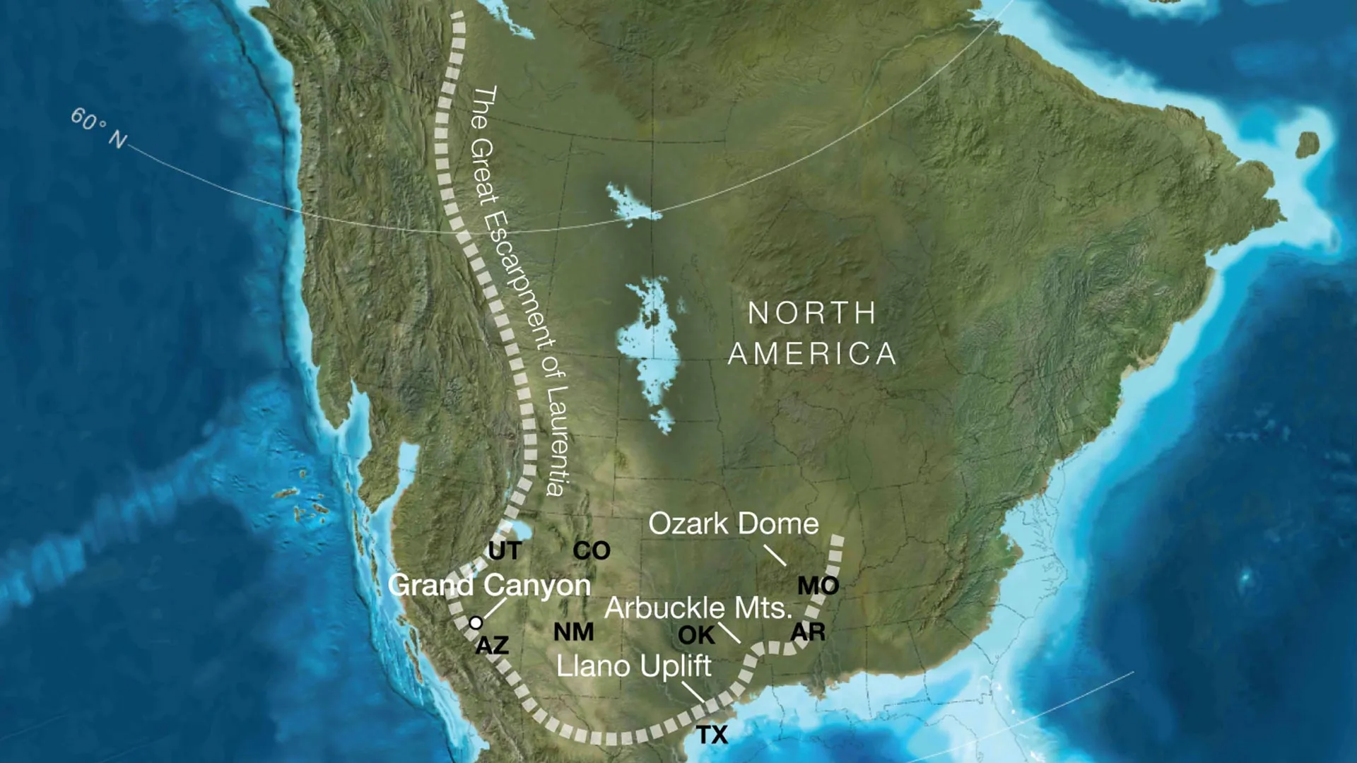
At the heart of the new discovery is a massive topographical boundary that once defined the western edge of ancient North America, then known as the paleocontinent Laurentia. According to the research, this ancient escarpment featured sheer rock faces reaching heights of up to one kilometer (about 3,280 feet) and extended across an immense geographic footprint.
Today, the remnants of this tectonic collision and subsequent erosion can be traced across a staggering swath of the United States. The researchers propose that the ancient escarpment cut across regions that now encompass modern-day Arizona, Utah, Idaho, Wyoming, Colorado, Texas, Oklahoma, Arkansas, Missouri, and Illinois.
- The Core Discovery: An ancient, kilometer-high escarpment formed ~800 million years ago during the fragmentation of the supercontinent Rodinia.
- Geographic Scale: The cliff system stretched for thousands of kilometers across what is now the interior and western United States.
- The Grand Canyon Connection: Erosion along this rocky boundary stripped away massive amounts of overburden, progressively bringing the canyon’s ancient crystalline basement rocks to the surface long before the Colorado River existed.
- Global Collaboration: The study was a joint effort involving the University of Southampton, the GFZ Helmholtz Centre for Geosciences and the University of Potsdam in Germany, and the University of Illinois Urbana-Champaign in the USA.
Crucially, this mechanism provides a missing chapter in the biography of the Grand Canyon. While tourists today marvel at rock strata stretching back nearly two billion years, geologists have long grappled with the frustrating reality that more than half of that comprehensive rock record is missing entirely—a baffling geological hiatus that has sparked academic debate for over a century.
Chronology: A Billion-Year Timeline of Continental Upheaval
To understand how a wall of rock formed 800 million years ago relates to a canyon cut primarily within the last six million years, geologists must look at a vast, multi-stage planetary timeline.
1. The Proterozoic Era (2 Billion to 1 Billion Years Ago)
The deepest rocks exposed at the bottom of the Grand Canyon—such as the Vishnu Schist—formed deep within the Earth’s crust during intense mountain-building events (orogenies) roughly 1.7 to 2 billion years ago. For hundreds of millions of years, these crystalline rocks remained buried deep beneath the surface, insulated from the atmosphere.
2. The Breakup of Rodinia (~800 Million Years Ago)
The supercontinent Rodinia, which had previously locked Earth’s landmasses into a single, cohesive global block, began to tear apart. As tectonic plates pulled away from each other, significant continental rifting occurred along the western margin of Laurentia. This rifting caused localized tectonic uplift, creating extreme topography: towering, steep-sloped escarpments and high ground.
3. The Great Escarpment Migration (700 to 500 Million Years Ago)
As the towering cliff systems were exposed to surface elements, relentless weathering and erosion began to hammer the rock face. Over tens of millions of years, this giant escarpment did not simply wear down in place; it systematically migrated inland. The Southampton-led team estimates that this erosive retreat stripped away an astonishing five to ten kilometers (three to six miles) of rock across large swathes of the region. This monumental stripping event exposed the ancient crystalline basement rocks right at the surface.
4. The Neoproterozoic to Paleozoic Transition
With the basement rocks exposed and planed flat by prolonged erosion, shallow seas periodically advanced and retreated across the continent. Sediments were deposited directly on top of these ancient, weathered crystalline rocks, sealing in the massive temporal gap known as the Great Unconformity.
5. The Modern Era (Past 6 Million Years)
Only recently in geological terms—roughly six million years ago—did the Colorado River begin its famous downward incision. Rather than carving virgin crust, the river was essentially exploiting a pre-conditioned landscape, cutting downward through sedimentary layers that had already been brought remarkably close to the surface by ancient tectonic and erosional forces.
Supporting Data: Modeling the Lost North American Landscape
Reconstructing a landscape that vanished hundreds of millions of years ago is no small feat. To test their hypothesis, the research team adopted a multidisciplinary approach, marrying numerical landscape evolution models with high-resolution plate tectonic reconstructions.
By simulating how continental margins behave when subjected to rifting and subsequent thermal cooling, the researchers tracked the lifecycle of escarpments observed in modern analog environments. They noted striking structural and dynamic similarities between the proposed ancient North American escarpment and active, long-lived escarpment systems found today in places like the Great Escarpment of South Africa, eastern Brazil, peninsular India, and the margins of Antarctica.
"Our work suggests that tectonic uplift related to continental rifting and breakup created both steep slopes and high ground, providing the mountainous terrain that rivers and glaciers could readily erode," noted Professor Thomas Gernon of the University of Southampton, the study’s lead author.
The model’s predictions align remarkably well with independent field data. Decades of geological studies across the southwestern United States have consistently pointed to the localized disappearance of roughly 5 to 10 kilometers of stratigraphic section prior to the Paleozoic era. Until now, the exact mechanism capable of uniformly removing such a colossal volume of rock over such a vast area remained heavily debated. The identification of a migrating continental-scale escarpment provides a mathematically and geologically sound answer.
Furthermore, the team’s reconstructions indicate that when Rodinia fragmented, the geographic coordinates corresponding to the future Grand Canyon sat in a position relative to the continental edge that closely mirrors the margins of modern rifted cratons. This structural positioning would have subjected the area to sustained, aggressive escarpment retreat, perfectly matching the observed geological footprint.
Official Responses and Expert Perspectives
The academic community has received the study with immense enthusiasm, viewing it as a major step forward in understanding continental evolution and surface-crust interactions.
Professor Thomas Gernon emphasized that the research bridges a critical gap in our understanding of the Earth’s upper crust. "Our paper suggests the Canyon’s basement rocks were progressively brought to the surface as part of an immense escarpment that developed during the breakup of an ancient supercontinent," Gernon stated.
He further highlighted the study’s implications for the Great Unconformity—a globally recognized geological phenomenon where rock layers separated by hundreds of millions of years sit directly on top of one another.
"This long-lived tectonic landscape provides a missing piece in understanding why erosion associated with the Great Unconformity varies so dramatically across the southwestern US," Gernon explained. By demonstrating how tectonic uplift and escarpment retreat worked in tandem, the team has demystified how such vast quantities of rock could vanish without leaving behind the massive sedimentary deposits one might intuitively expect.
Co-researchers from Germany and the United States echoed these sentiments, pointing out that the methodology opens new avenues for studying other cratonic interiors around the world. Dr. Gernon noted that geologists frequently encounter massive, inexplicable stratigraphic gaps on other continents. The framework established in this study provides a new lens through which to interpret those silent chapters in Earth history.
"By comparing the Grand Canyon’s ancient history with active landscapes like the Great Escarpment of South Africa, we’re able to see North America’s most iconic geologic landmark in an entirely new light," Gernon added.
Implications: Rewriting the History of North American Geology
The discovery of this ancient kilometer-high escarpment carries profound implications that stretch far beyond the borders of Arizona.
1. Reshaping Continental Topography and Hydrology
A mountain rim of this magnitude would have fundamentally controlled the geography of ancient Laurentia. Rising a kilometer or more above the surrounding terrain, this escarpment acted as a massive topographical barrier. It dictated the pathways of ancient rivers, controlled where eroded sediments were transported and ultimately deposited, and influenced regional climate patterns.
2. Contextualizing the Rise of Complex Life
The timing of the escarpment’s erosion coincides intriguingly with the period leading up to the Cambrian explosion—a pivotal epoch roughly 540 million years ago when complex, multicellular animal life diversified rapidly across the globe. Geologists have long theorized that increased nutrient runoff from eroding continental landmasses may have chemically fertilized the shallow oceans, fueling the explosion of life. A mountain rim of continental proportions undergoing aggressive, multi-million-year erosion provides an ideal engine for supplying those vital nutrients to ancient marine basins.
3. A New Paradigm for Global Geology
Perhaps the most significant legacy of this research is its potential application to global geology. Continents are dynamic, restless entities, constantly assembled and disassembled through the supercontinent cycle. By proving that ancient escarpments can survive and migrate across hundreds of millions of years—leaving behind subtle yet definitive clues in the modern rock record—the study offers geologists a powerful new diagnostic tool.
As scientists continue to refine models of mantle dynamics, tectonic rifting, and surface denudation, the Grand Canyon will undoubtedly remain a focal point of inquiry. Yet, thanks to this international team of researchers, we now know that the canyon’s story begins long before the first drop of the Colorado River ever touched its stone. It is a tale written in the slow, grinding collapse of a vanished mountain world—a prehistoric monument whose ghost still haunts the depths of America’s most famous canyon.
