

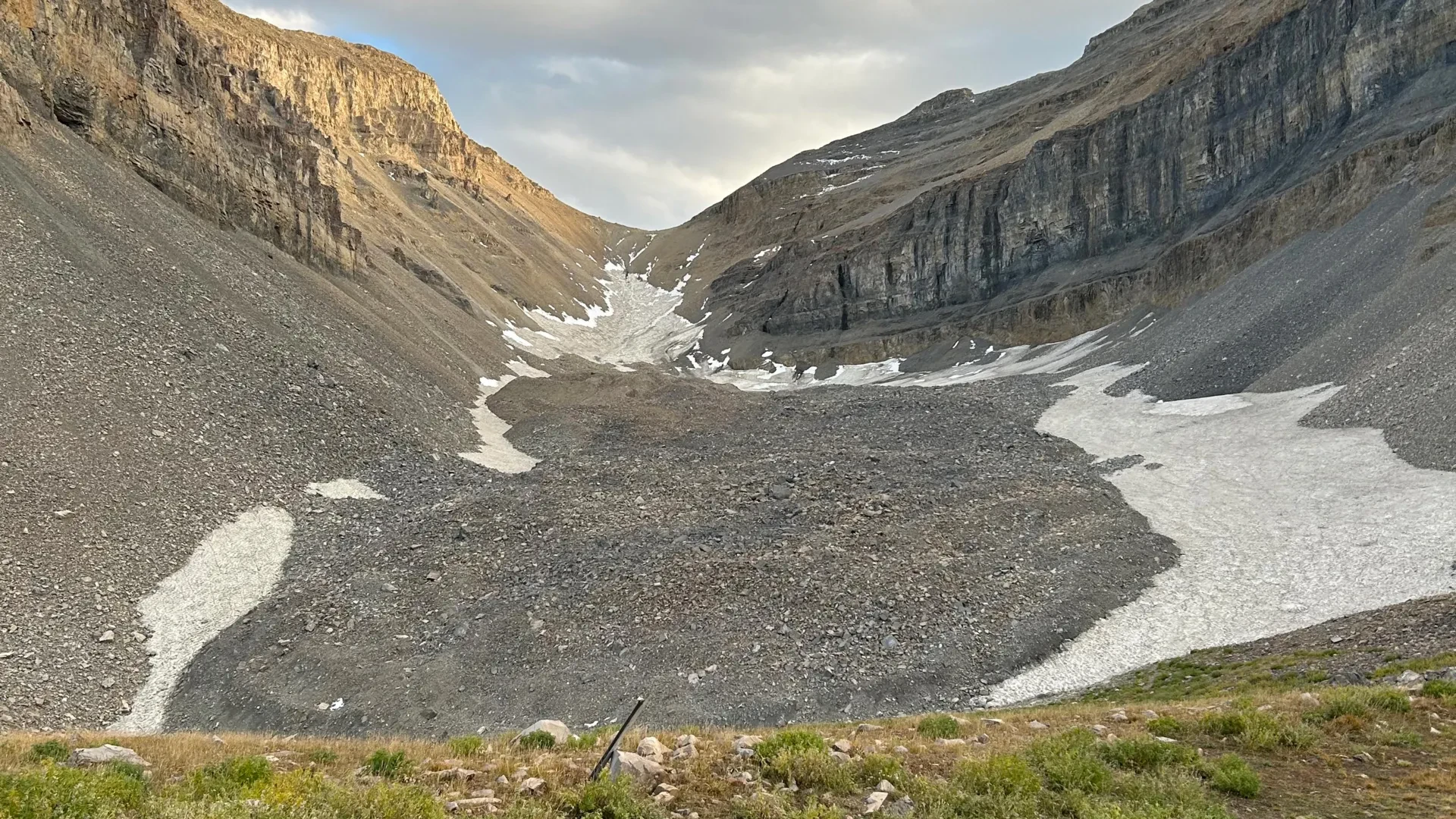
SALT LAKE CITY — To the casual hiker, high-altitude alpine terrain often appears as little more than a chaotic expanse of gray rubble, talus, and broken stone. Across the rugged crags of Utah’s Wasatch and Uinta ranges, as well as the windswept heights of the La Sal Mountains near Moab, the landscape seems dry, barren, and thoroughly exposed to the elements. Yet beneath the shifting surface stones of these high-elevation environments lies a profound and largely unmeasured secret: vast subterranean reserves of solid ice.
In a pair of groundbreaking new studies, geologists at the University of Utah have peered beneath the rocky veneer of one of the state’s most prominent alpine features—the Timpanogos Rock Glacier, nestled beneath the towering, precipitous summit of Mount Timpanogos between Salt Lake City and Provo. By marrying meticulous field physics with advanced statistical modeling, the research team has not only unmasked the complex origins of these deceptive geological formations but has also mapped their internal structures in unprecedented three-dimensional detail.
The findings are striking. Far from being mere piles of surface debris, the Timpanogos Rock Glacier is a hyper-concentrated reservoir of frozen water, containing an estimated 1.5 million cubic meters of ice. To put that scale into perspective, it is enough volume to fill approximately 600 Olympic-sized swimming pools, or match the massive physical dimensions of the Great Pyramid of Giza in Egypt.
"There’s a lot of ice that’s hidden in Utah’s mountains," said Leif Anderson, a glaciologist and co-author of the research. "When we are high in the mountains and walking across loose rocks or rubble, you don’t realize there could be 120 feet of ice buried beneath your feet."
Main Facts
Unlike conventional, pristine alpine glaciers—which proudly display fields of blue-white, exposed ice cascading down mountain valleys—rock glaciers are masters of geological camouflage. From the air or a distant trail, they resemble creeping, sprawling rivers of loose stone. However, beneath a protective, insulating carapace of rock debris lies a hidden matrix of ancient ice.
The investigation into the Timpanogos Rock Glacier focused on two fundamental questions: How much water is actually trapped within these subterranean vaults, and how do these bizarre formations come into existence in the first place?
The core discoveries of the research include:
- Astonishing Ice Purity: The Timpanogos Rock Glacier is composed of roughly 83% ice and only 17% loose rock by volume, making it surprisingly ice-rich given its rugged, debris-laden exterior.
- Massive Water Volume: The single rock glacier beneath Mount Timpanogos holds approximately 1.5 million cubic meters of frozen water.
- Statewide and Global Significance: Extrapolating data from Timpanogos across Utah’s cataloged inventory of 836 rock glaciers reveals a total state reserve of roughly 1 gigaton of water—equivalent to about 815,000 acre-feet. Globally, the roughly 50,000 known rock glaciers may hold up to 48 gigatons of water.
- Post-Ice Age Origins: Contrary to popular assumption, these rock glaciers are not stagnant remnants of the last Ice Age (which peaked between 21,000 and 18,000 years ago). Instead, they are dynamic reservoirs that accumulated during the subsequent millennia.
- Novel Imaging Technique: Researchers successfully deployed a high-precision gravimeter and a 3D Bayesian inversion statistical model to "see" through solid rock and map the interior density of the glacier, acting much like a medical CT scan for the mountain.
Chronology of the Discovery
The revelation of Mount Timpanogos’s hidden interior was the result of a multi-year collaborative effort spanning intensive field expeditions, complex computational physics, and successive academic publications.
The Foundation: Summer 2023
The groundwork for understanding how these formations grow began in the summer of 2023. Isaiah Davies, an undergraduate student at Stanford University participating as a visiting summer researcher at the University of Utah, stepped into the role of lead author for the team’s initial line of inquiry. Davies and his colleagues investigated the micro-climatic and geological mechanisms that feed mass into the Timpanogos Rock Glacier. Their work laid out how headwall erosion and climate variability conspire to dump rocky debris over persistent snowpacks, sealing them away from the sun. This foundational paper was published in Geophysical Research Letters on April 2, 2026.
The Field Campaign: Fall 2024
Armed with theoretical models of how snow and rock interact, former University of Utah Department of Geology & Geophysics graduate student Bronson Cvijanovich took the research into the physical elements. During the autumn of 2024, Cvijanovich led a grueling series of six field expeditions up to the Timpanogos Rock Glacier, operating in the shadow of the mountain’s prominent peak and just above Emerald Lake.
Carrying sensitive, state-of-the-art geophysical equipment across shifting terrain, Cvijanovich executed a meticulous spatial survey. He collected gravity measurements at 232 distinct locations laid out in a rigid grid across the body of the rock glacier, with each data point spaced precisely 25 meters (roughly 80 feet) apart.
The Computation: Late 2024 to Mid-2025
Once the raw gravitational data was captured, the physical heavy lifting transitioned into high-powered digital computation. The team could not simply read the gravimeter numbers at face value; they had to account for a myriad of confounding physical variables. This included correcting for subtle, constant fluctuations caused by the celestial positions of the sun and the moon, as well as localized variations in surface terrain, elevation, and latitude.
Under the guidance of geophysics professor Michael Thorne and glaciologist Leif Anderson, the research team engineered a novel mathematical approach utilizing Bayesian statistics to invert the gravity data.
"We spent months of computation time doing the imaging with our new techniques," Thorne explained. By processing these corrections, the team successfully reconstructed a high-resolution, three-dimensional digital model of the glacier’s internal ice architecture.
The Publication: August 2025 – August 2026
The culmination of the gravimetric mapping and 3D modeling was formally detailed in a paper titled "The internal ice content of Timpanogos Rock Glacier, Utah, USA from 3-D Bayesian inversion of gravity data," which was published on August 26 in the Journal of Geophysical Research. This study provided the empirical proof of the glacier’s staggering 1.5-million-cubic-meter water content, cementing a brand-new methodological framework for glaciologists worldwide.
Supporting Data and Methodology
While satellite imagery has long allowed geoscientists to map the surface boundaries and aerial footprints of rock glaciers across the globe, satellites are fundamentally blind to what lies beneath the surface crust. Traditional radar and seismic methods often struggle in rock glaciers due to the extreme scattering of signals caused by chaotic surface boulders.
To overcome this, the University of Utah team leveraged the laws of physics, specifically the differences in mass density.
[Mount Timpanogos Bedrock] ---> Higher Mass Density
[Subsurface Rock Glacier]   ---> Lower Mass Density (83% Ice / 17% Rock)
"There is a large contrast in mass density between the rock that makes up Mount Timpanogos and the much lower density ice that is in the rock glacier adjacent to it," Thorne noted.
A gravimeter measures the local acceleration of gravity. Because ice is significantly less dense than the solid limestone and quartzites of the mountain’s headwalls, a gravimeter stationed over a thick body of buried ice will register a subtle, measurable decrease in gravitational acceleration. By mapping these minute differentials across their 232-point grid, the researchers could accurately calculate the thickness, volume, and contours of the subterranean ice sheet.
Unraveling the Genesis of Utah’s Rock Glaciers
Beyond calculating volume, the researchers sought to solve the mystery of how these formations came to be. Conventional alpine glaciers are shrinking rapidly across the American West due to rising global temperatures, leading many to assume that rock glaciers are merely the dying, debris-choked gasps of the last Ice Age.
However, the team’s mathematical modeling demonstrated otherwise. Utah’s rock glaciers are not ancient glacial relics. Instead, they are ongoing, active geologic features that formed during the thousands of years after the major Pleistocene ice sheets retreated.
In steep alpine environments like the Wasatch Range, physical weathering causes the mountains to actively erode. Sheer rock faces shed millions of tons of stone and talus down into high-altitude cirques and valleys. Crucially, this falling debris avalanches over persistent patches of winter snow.
"In the Wasatch, the mountains themselves are eroding and burying the snow, and that’s why the rock glaciers exist," Anderson explained.
By blanketing the snow in thick layers of insulating rock, the mountains effectively shield the frozen water from summer solar radiation and warm ambient air. Over centuries, compaction, refreezing, and ongoing rockfalls transform this buried snow into dense, multi-layered bodies of internal glacial ice.
Official Responses and Perspectives
The implications of the research have drawn praise from academic institutions, geological surveys, and climate science foundations alike. The project was made possible through financial and logistical backing from a coalition of major scientific bodies, including the U.S. Geological Survey (USGS), the National Science Foundation (NSF), the University of Utah’s Wilkes Center for Climate Science & Policy, the U’s Office of Undergraduate Research, and the Summer Program for Undergraduate Research (SPUR).
Researchers emphasize that the interdisciplinary nature of the project—combining undergraduate field participation, advanced geophysical inversion algorithms, and traditional glaciology—was key to its success. By giving students like Isaiah Davies and Bronson Cvijanovich direct leadership roles in the field and computational labs, the university has fostered the next generation of alpine scientists.
"What started as a set of boots-on-the-ground measurements in the rugged terrain above Emerald Lake has opened a window into a hidden hydrological network across the American West," said a representative close to the Wilkes Center. "We are only just beginning to understand the scale of these resources."
Broader Implications: A Hidden Mountain Water Reserve
The most sweeping implication of the University of Utah studies extends far beyond the borders of Mount Timpanogos. Having established a reliable mathematical relationship between a rock glacier’s visible surface area and its hidden interior ice volume, the researchers were equipped with a scaling tool applicable on a global scale.
There are 836 officially identified rock glaciers scattered across the state of Utah alone. When the research team applied their volumetric formulas to this statewide catalog, the numbers proved staggering: Utah’s rock glaciers collectively harbor an estimated 1 gigaton of water, which translates to roughly 815,000 acre-feet of frozen reserves. To put that into perspective, an acre-foot is generally enough water to supply one suburban American household for a year.
Scaling their equations outward to cover the roughly 50,000 known rock glaciers worldwide, the researchers calculated a global subterranean reservoir of approximately 48 gigatons of water. A single gigaton is equivalent to one cubic kilometer of water—enough to fill 400,000 Olympic swimming pools.
Climate Resilience and Future Water Security
For arid and semi-arid states like Utah, where growing populations rely heavily on winter snowpacks for municipal water, agriculture, and ecosystem management, these hidden reserves carry immense ecological and economic significance.
As traditional surface snowpacks become increasingly volatile and vulnerable to early seasonal melting due to climate change, rock glaciers act as hyper-insulated, slow-release alpine water towers. The thick armor of surface talus shields the internal ice from rapid atmospheric warming, allowing the subterranean reservoirs to slowly discharge meltwater into high-altitude streams long after conventional snowpacks have vanished.
However, researchers issue a note of caution: while rock glaciers are more resilient to temperature spikes than clean-ice glaciers, they are not entirely immune to persistent atmospheric warming. Understanding how much water is locked inside them is the vital first step toward managing and protecting the West’s hidden water security for the decades to come.
"When you hike through the Wasatch and look out over fields of seemingly dead rock, it’s easy to miss the bigger picture," Anderson concluded. "These mountains are quietly holding millions of gallons of water, preserved under stone, waiting to sustain the ecosystems below."
