

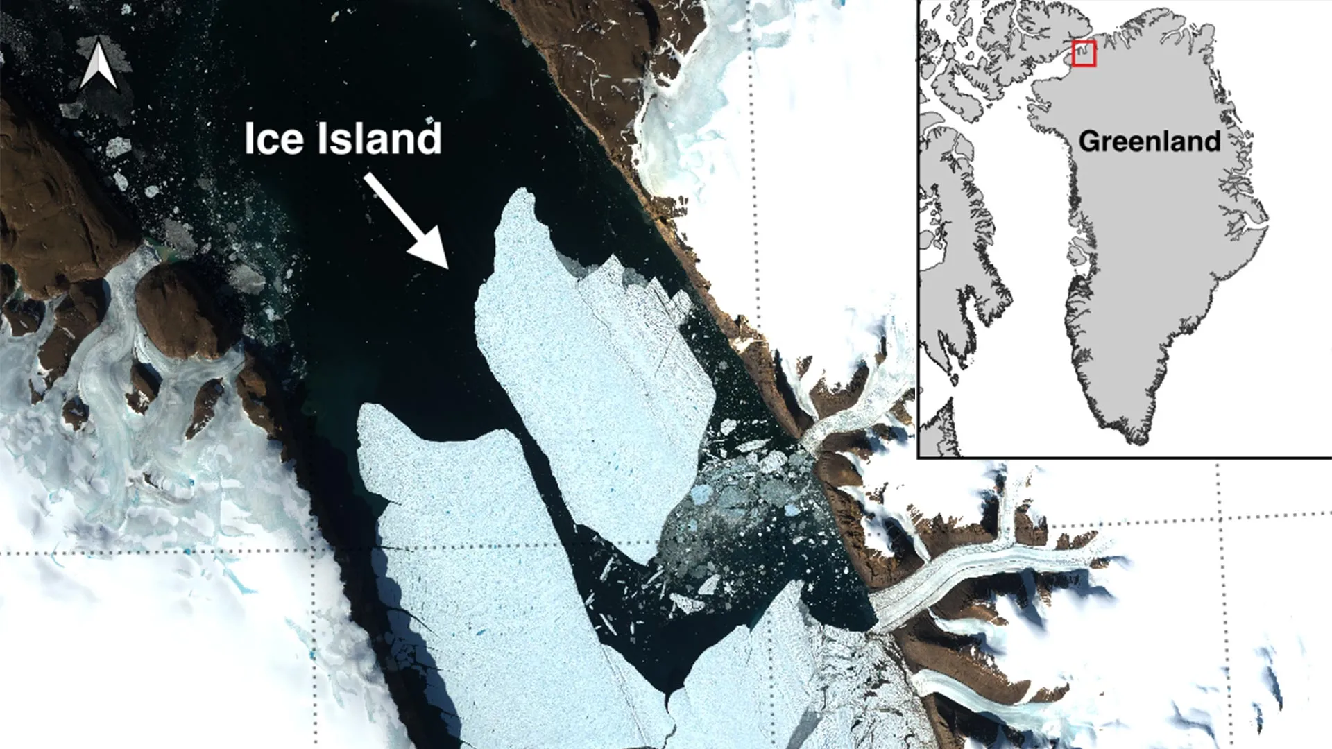
OTTAWA, ONTARIO — In a dramatic illustration of the accelerating changes reshaping the Earth’s cryosphere, an international coalition of glaciologists has documented a monumental calving event at the Petermann Glacier in northwest Greenland. On August 4, 2026, the glacier birthed a colossal tabular ice island measuring 76.4 square kilometers—an expanse roughly equivalent to the land area of Manhattan Island.
This staggering loss of floating ice marks the largest single fracture at Petermann Glacier since 2012 and stands as the most significant Arctic calving event recorded since 2020. The newly separated mass, estimated to be up to 150 meters thick, has broken away from the glacier’s vulnerable floating ice tongue. For the scientific community, this monumental breakup is not merely a regional curiosity; it represents a high-definition window into the mechanics of polar disintegration, offering critical insights into how massive ice shelves respond to warming global temperatures and shifting ocean dynamics.
Led in part by the University of Ottawa (uOttawa) in close collaboration with the University of Stirling, Environment and Climate Change Canada (ECCC), Lancaster University, and the University of Leeds, the research team is tracking the lifecycle of this newly formed ice island. As the colossal block begins its long, hazardous journey through Arctic waters, it serves as a stark reminder of the fragile state of Greenland’s northern marine-terminating glaciers.
Chronology of a Collapse: From Fractures to Freedom
The birth of the 76.4-square-kilometer ice island was not an overnight anomaly, but rather the culmination of years of structural degradation meticulously cataloged by satellite surveillance. Scientists have maintained an unbroken watch over the Petermann Glacier’s floating ice tongue since 2019, utilizing high-resolution radar and optical satellite imaging to monitor its physical integrity.
Over the past several years, researchers watched with mounting concern as a network of stress fractures widened across the centerline of the ice tongue. These fissures served as visible scars of a structural decline driven by a combination of atmospheric warming and the relentless thermal erosion of subsurface ocean currents eating away at the glacier’s underside.
The definitive sequence of the August 2026 event unfolded with startling precision across a matter of days:
- August 3, 2026: Radar imagery captured by the European Space Agency’s Sentinel-1 mission reveals accelerated structural deterioration and widening rifts along the centerline of the Petermann ice tongue, indicating that a catastrophic failure is imminent.
- August 4, 2026 (Day of Calving): As tension builds to a critical threshold, the structural bonds holding the eastern flank of the ice tongue to the main glacier fail entirely.
- August 4, 2026 (20:00 UTC): The final severance occurs. The colossal 76.4 km² tabular iceberg fully separates from the glacier, entering the fjord as an independent floating ice island.
Adam Garbo, a PhD student in glaciology at uOttawa’s Department of Geography, Environment and Geomatics, was the first to identify the completed calving event through his daily analysis of satellite telemetry.
"Petermann Glacier has long been one of Greenland’s largest remaining ice tongues," remarks Garbo, reflecting on the years of monitoring that led to this discovery. "We’ve anticipated this break for years, and seeing it finally happen is remarkable, though it underscores the profound changes currently rewriting the geography of the Arctic."
Supporting Data: Dimensions, Projections, and Unprecedented Scale
To fully comprehend the magnitude of the August 4 event, one must look closely at the quantitative metrics compiled by the research collective. The newly freed ice island is an imposing geographical feature. Plunging as much as 150 meters into the frigid Arctic waters, the vast majority of its mass is hidden beneath the surface, sustained by the buoyant properties of seawater.
While flat-topped, tabular icebergs are a relatively common, almost routine occurrence in the Southern Ocean surrounding the Antarctic Ice Sheet, ice islands of this scale are exceptionally rare in the Arctic. Their rarity, combined with their longevity, makes them extraordinarily valuable floating laboratories for polar researchers.
However, glaciologists warn that the 76.4 km² fracture is only a chapter in a larger, ongoing narrative of retreat. Analysis of the remaining ice tongue reveals that the structural rifts responsible for the August event have not closed; instead, they continue to propagate deeper into the glacier’s remaining floating platform.
According to projected satellite models, two additional massive sections of the Petermann ice tongue are poised to detach in the near future:
- The Middle Segment: Projected to measure approximately 94 km².
- The Outer Segment: Projected to measure approximately 84 km².
Should both of these anticipated calving events occur as predicted, the combined loss from these three consecutive fractures will strip roughly 254 km² from the Petermann Glacier’s floating ice tongue. This cumulative loss will shrink the existing tongue by an estimated 22 percent, drastically altering the physical geometry of the northwest Greenland coastline and reducing the buttressing effect that helps stabilize inland ice flow.
Official Responses and International Collaboration
The discovery of the Petermann ice island highlights the power of modern, multi-institutional scientific collaboration. The research initiative unites top-tier academic expertise with federal environmental agencies, bridging the gap between theoretical glaciology and practical environmental monitoring.
Dr. Anna Crawford of the University of Stirling emphasizes the broader scientific implications of studying Arctic ice islands.
"While large, tabular icebergs are relatively common in the Southern Ocean that surrounds the Antarctic Ice Sheet, Arctic ice islands are far rarer," Dr. Crawford explains. "Because they are so seldom observed in the north, each event gives us a unique dataset. By studying Arctic ice islands, we will gain knowledge that can be transferred across polar regions, helping us refine models of how marine-terminating glaciers fracture and retreat under a changing climate."
Beyond the academic sphere, operational government agencies have mobilized to track the physical trajectory of the drifting ice. Environment and Climate Change Canada (ECCC), drawing on decades of experience monitoring Arctic ice shelf breakups, has integrated the Petermann ice island into its ongoing hazard-tracking protocols.
Dr. Abigail Dalton of the Canadian Ice Service, a division of ECCC, stresses the dual nature of these ice islands as both scientific treasures and navigational hazards.
"These are immensely thick blocks of ice that possess the structural integrity to drift intact for years," Dr. Dalton specifies. "Over time, as they encounter warmer waters, wave action, and collisions with the seabed or other ice masses, they gradually fracture into smaller, highly unpredictable pieces. These secondary fragments become notoriously difficult to track, posing significant, long-term hazards to vessels and offshore resource operations."
Wider Implications: Marine Safety, Climate Indicators, and Future Outlook
The calving of the Petermann Glacier reverberates across multiple domains, touching upon marine safety, industrial economics, and global climate science.
1. Navigational Hazards and Shipping Safety
As the Arctic ice pack continues to experience seasonal thinning and recession, interest in northern shipping routes and resource extraction has intensified. However, the introduction of massive ice islands into these migration corridors complicates maritime safety. The 76.4 km² monolith, along with the subsequent ice islands expected to break away in the coming months, will be swept by ocean currents through narrow channels such as Nares Strait. As they break down into smaller "bergy bits" and growlers—pieces of ice that sit low in the water and are difficult to detect via standard shipboard radar—they present a localized hazard to commercial cargo vessels, fishing fleets, and scientific expeditions.
2. The Health of Greenland’s Ice Sheet
While calving is a natural process through which glaciers maintain mass equilibrium, the frequency and scale of recent events at Petermann and other major Greenlandic glaciers point to a systemic acceleration. Floating ice tongues act as stabilizing dams or "brakes," exerting back-pressure on the grounded ice streams behind them. As these tongues shrink and fracture, the resistive force diminishes, potentially speeding up the flow of inland ice into the ocean and contributing at an accelerated rate to global sea-level rise.
3. The Road Ahead for Glaciology
For researchers like Adam Garbo, Dr. Crawford, Dr. Dalton, and their international peers, the work has only just begun. The team plans to maintain continuous surveillance of the Petermann Glacier and its runaway offspring using a multi-tiered approach. This includes high-resolution optical and radar satellite imagery, airborne reconnaissance missions where feasible, and satellite tracking beacons deployed to monitor drift vectors and oceanographic interactions.
Ultimately, the 2026 Petermann calving event stands as a monumental physical marker in our rapidly warming world. It forces a recalibration of our understanding of polar stability and underscores the urgent need for sustained, international monitoring of the Arctic’s fragile margins. As the Manhattan-sized ice island drifts slowly southward into the dark waters of the Canadian Arctic Archipelago, it carries with it the physical evidence of a changing planet—and a warning of the transformations yet to come.
