

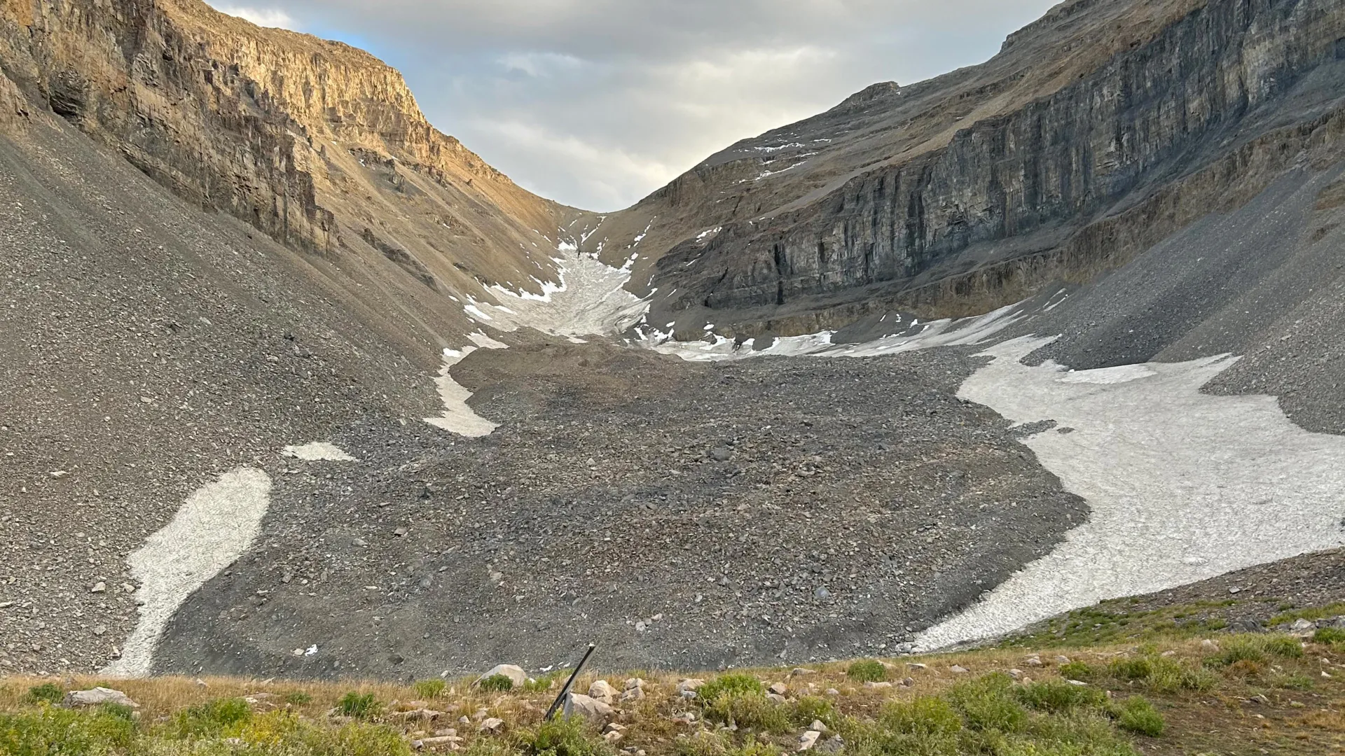
SALT LAKE CITY — To the casual hiker scaling the rugged, jagged trails of Utah’s Wasatch and Uinta ranges, the landscape appears as a chaotic jumble of dry talus, sprawling boulder fields, and sun-baked scree. To the untrained eye, these formations are little more than geological scar tissue—heaps of shattered rock left behind by centuries of alpine erosion.
However, groundbreaking new research from a team of geologists at the University of Utah reveals that these barren-looking landscapes hide a secret of monumental proportions. Beneath miles of loose, grey surface rubble lie massive, subterranean rivers and sheets of solid ice. These geological formations, known as rock glaciers, are far more than simple piles of debris; they are heavily insulated, highly concentrated reservoirs of frozen water that could hold the key to understanding regional hydrology, climate history, and future mountain water security.
In two comprehensive, recently published studies, University of Utah researchers took an unprecedented look inside one of the state’s largest and most prominent formations: the Timpanogos Rock Glacier, tucked directly beneath the towering, precipitous summit of Mount Timpanogos between Salt Lake City and Provo. By deploying state-of-the-art geophysical equipment, deploying advanced Bayesian statistical modeling, and conducting rigorous mathematical analyses, the research team has not only mapped the hidden interior of a major rock glacier in vivid three dimensions but has also calculated the staggering volume of water locked away beneath Utah’s peaks.
The findings upend traditional understandings of alpine geology. Far from being dead, static relics of a bygone era, these hidden glaciers are active, dynamic systems that function as vital underground water towers in an increasingly arid American West.
Main Facts: What is a Rock Glacier and What Did the Studies Find?
Unlike conventional, pristine alpine glaciers—which proudly display vast, sweeping expanses of blue-white surface ice like those found in Glacier National Park or the high peaks of Alaska—rock glaciers are masters of disguise. From above, they resemble sprawling rivers or lobes of loose rock. Yet, beneath an insulating outer layer of coarse debris, they can conceal immense quantities of ice.
The Timpanogos Rock Glacier, situated in a high-altitude cirque above Emerald Lake, serves as a prime case study for this phenomenon. According to the research team, this single geological formation contains an estimated 1.5 million cubic meters of frozen water. To put that staggering figure into perspective, it is enough water to fill roughly 600 Olympic-sized swimming pools.
Bronson Cvijanovich, a former graduate student in the University of Utah’s Department of Geology & Geophysics and lead author of one of the studies, offers another striking visual comparison: the volume of ice hidden beneath the rocks of Mount Timpanogos is roughly equivalent to the volume of the largest pyramid at Giza in Egypt.
More surprisingly, the internal composition of the rock glacier leans heavily toward ice rather than stone. "Timpanogos Rock Glacier is surprisingly ice rich. It is 83% ice and 17% loose rock," Cvijanovich noted.
This extreme concentration of ice challenges conventional assumptions about what hikers and scientists are walking across in high-altitude environments. Leif Anderson, a co-author and glaciology professor at the university, emphasizes the counterintuitive nature of the terrain: "There’s a lot of ice that’s hidden in Utah’s mountains. When we are high in the mountains and walking across loose rocks or rubble, you don’t realize there could be 120 feet of ice buried beneath your feet."
Chronology of Discovery: Mapping the Invisible
The road to uncovering the secrets of Mount Timpanogos required a blend of old-school alpine field endurance and cutting-edge geophysical innovation. The research effort unfolded in distinct phases over several years, culminating in a pair of landmark publications.
The Summer of 2023: Laying the Groundwork
The foundational phase of the research began in the summer of 2023, drawing on collaborative academic efforts. Isaiah Davies, an undergraduate student at Stanford University working as a visiting summer researcher at the University of Utah, stepped in as lead author for the initial study. This phase focused heavily on understanding how these bizarre formations form and grow, examining the dynamic relationship between headwall erosion, climate variability, and the accumulation of debris-covered snow. This work laid the theoretical groundwork for understanding that Utah’s rock glaciers are not, as previously thought, stagnant remnants of the Pleistocene Ice Age (which peaked between 21,000 and 18,000 years ago), but rather younger features that developed continuously over the millennia following the retreat of major ice sheets.
The Fall of 2024: High-Altitude Fieldwork
With the theoretical framework established, the focus shifted to empirical measurement. In the fall of 2024, Bronson Cvijanovich spearheaded a grueling series of field expeditions to the Timpanogos Rock Glacier. Hauling heavy, sensitive scientific instrumentation up steep alpine switchbacks to elevations above Emerald Lake, the team executed a meticulous surveying campaign.
Across six separate field trips, Cvijanovich collected gravity measurements at an astonishing 232 distinct locations. These points were arranged in a tight, systematic grid across the surface of the glacier, with each measurement station separated by a mere 25 meters (approximately 80 feet).
The instrument of choice for this task was a high-precision gravimeter. By detecting minute, infinitesimal differences in the Earth’s gravitational pull at each grid point, the gravimeter allowed researchers to sense subterranean density contrasts. Denser surrounding bedrock exerts a stronger gravitational pull, while significantly lighter buried ice reduces local gravity. By mapping these micro-variations, the team could effectively "see" through solid rock and debris, estimating the precise shape, depth, and thickness of the hidden glacier below.
Computational Breakthroughs and 3D Imaging
Collecting the raw gravity data, however, was only half the battle. Raw gravimeter readings are notoriously sensitive to external noise, including subtle gravitational shifts caused by the changing positions of the sun and moon, as well as local variations in surface terrain, elevation, and latitude.
Once the data was thoroughly scrubbed and corrected, Michael Thorne, a geophysics professor and co-author on the study, helped spearhead a novel computational approach. The team utilized advanced Bayesian statistics—a powerful probabilistic method—to invert the gravity data and construct a high-resolution, three-dimensional image of the glacier’s internal architecture.
"We spent months of computation time doing the imaging with our new techniques," Thorne explained. While traditional satellite imagery can successfully map the surface footprint of a rock glacier, it remains blind to its depth and internal structure. The new gravity-inversion method acts much like a medical CT scan, peering beneath the exterior skin of rubble to reveal the anatomy hidden inside.
Supporting Data: Scaling Up to Regional and Global Reserves
The success of the Timpanogos mapping project provided researchers with a powerful calibration tool. By establishing a definitive mathematical relationship between a rock glacier’s surface area and the total volume of ice stored beneath it, the team could look beyond a single mountain and scale their calculations across broader landscapes.
Satellite inventories have cataloged approximately 836 rock glaciers across the state of Utah alone, spanning the Wasatch and Uinta ranges, as well as southern formations like those on the La Sal Mountains near Moab.
When the researchers applied their new volume-scaling models to these regional inventories, the numbers proved staggering:
- Utah Reserves: Rock glaciers across Utah are estimated to contain roughly 1 gigaton of water, which translates to approximately 815,000 acre-feet—a vital cache of liquid potential in a state heavily dependent on alpine snowpack for municipal and agricultural needs.
- Global Implications: Expanding the model worldwide, where roughly 50,000 rock glaciers have been identified, the team calculates that these subterranean ice deposits collectively harbor an astronomical 48 gigatons of water. To contextualize this, a single gigaton equals one billion metric tons (or one cubic kilometer of water), which is enough to fill 400,000 Olympic swimming pools.
The findings confirm that rock glaciers are not merely geological oddities, but major, globally significant reservoirs of freshwater.
Official Responses and Academic Insights
The publication of these findings has drawn widespread attention within the academic and geoscience communities, highlighting the collaborative nature of modern climate and geological research.
Reflecting on the unexpected ice richness of the Timpanogos formation, lead author Bronson Cvijanovich emphasized the dynamic nature of these systems. The research demonstrates that rock glaciers are actively nourished by mechanical processes unique to steep alpine environments.
According to co-author Leif Anderson, the formation of these glaciers is intimately tied to the steady erosion of Utah’s mountains. "In the Wasatch, the mountains themselves are eroding and burying the snow, and that’s why the rock glaciers exist," Anderson noted. Their newly developed mathematical models illustrate how seasonal rockfalls and avalanches repeatedly blanket persistent snowpacks in high-altitude cirques. This constant shedding of talus and debris effectively blankets the snow, insulating it from solar radiation and warm summer air, thereby preserving it for centuries and transforming transient snow into permanent, creeping glacial ice.
Professor Michael Thorne underscored the elegance of using gravity physics to solve a geological blind spot. "There is a large contrast in mass density between the rock that makes up Mount Timpanogos and the much lower density ice that is in the rock glacier adjacent to it," Thorne explained. "When we measure the gravitational acceleration over the rock glacier, we see a larger decrease in that gravitational acceleration as we make measurements over areas with thicker ice."
The research itself represents a testament to institutional and governmental collaboration. The studies were generously supported by a coalition of key scientific organizations, including:
- The U.S. Geological Survey (USGS)
- The National Science Foundation (NSF)
- The University of Utah’s Wilkes Center for Climate Science & Policy
- The University of Utah’s Office of Undergraduate Research
- The Summer Program for Undergraduate Research (SPUR)
The academic papers detailing these breakthroughs have been rolled out in premier scientific journals. The foundational work on formation mechanics, titled "Mass Addition to Timpanogos Rock Glacier: Debris-Covered Snow and the Importance of Interannual Variability in Headwall Erosion and Climate," was published on April 2, 2026, in Geophysical Research Letters. The structural imaging study, titled "The internal ice content of Timpanogos Rock Glacier, Utah, USA from 3-D Bayesian inversion of gravity data," was published on August 26 in the Journal of Geophysical Research.
Implications: Climate Resilience and Future Water Security
As the American West confronts persistent megadroughts, shifting precipitation patterns, and a warming climate that rapidly diminishes traditional mountain snowpacks, the discovery of these hidden subterranean ice reserves carries profound implications for water resource management.
For decades, hydrologists and water managers have relied primarily on snow-water equivalent (SWE) measurements taken from surface snow sensors to forecast seasonal streamflow and reservoir levels. However, conventional surface snow melts rapidly in the face of rising global temperatures.
Rock glaciers, by contrast, possess a natural protective armor. Their thick surface layers of coarse rock and boulders act as thermal blankets, shielding the vast stores of internal ice from direct solar radiation and buffer them against short-term temperature spikes. While conventional glaciers across the globe are rapidly retreating and disappearing, rock glaciers are far more resilient to climatic fluctuations, potentially releasing water slowly and steadily over extended periods well into the dry summer months.
Understanding that Utah’s rock glaciers contain an estimated 1 gigaton of water fundamentally alters how regional hydrologists must view mountain water storage. These systems represent a massive, long-term natural buffer against climate change.
Nevertheless, researchers caution that these reserves are not entirely immune to prolonged warming. As atmospheric temperatures continue to climb over decades and centuries, even the deep-seated ice within rock glaciers will eventually experience accelerated melting. Furthermore, because these formations are sensitive to the rate of headwall erosion and winter precipitation inputs, changes in climate will directly influence whether these subterranean glaciers continue to grow, stabilize, or begin a slow, irreversible collapse.
For now, the pioneering work of the University of Utah geologists has lifted the veil on a previously invisible component of the alpine water cycle. Hikers walking across the rugged boulder fields of Mount Timpanogos will never look at the landscape the same way again, knowing they are traversing a monumental, hidden frozen monument holding centuries of mountain water beneath their boots.
