

PORT MORESBY, PAPUA NEW GUINEA — Oceanographers frequently note a humbling paradox of modern science: human cartographers possess higher-resolution maps of the surfaces of the Moon and Mars than they do of Earth’s own abyssal depths. Nowhere is this contrast more acute than in the Bismarck Sea, situated north of Papua New Guinea. Despite harboring staggering geological complexity—including intricate webs of faults, volcanic edifices, tectonic rifts, scarps, and active subduction and spreading zones—the seafloor here remains stubbornly opaque. Much of it lies at crushing depths where traditional sonar mapping is exceptionally difficult, leaving researchers blind to the subterranean engine operating just beneath the waves.
That veil of ignorance was suddenly pierced on May 8, 2026, when a constellation of spaceborne sensors detected the unmistakable signatures of an unexpected submarine volcanic eruption. The event has opened a rare, real-time window into deep-sea geology, offering scientists an unprecedented opportunity to observe the birth of a potential new volcanic island from orbit.
Main Facts: The Bismarck Sea Awakening
The unfolding geological event is believed to be centered along Titan Ridge, an underwater volcanic structure located roughly 16 kilometers (10 miles) southeast of the site of a previous submarine eruption that occurred in 1972. Yet, despite the barrage of modern satellite data, fundamental mysteries remain. Scientists cannot yet say with absolute certainty which specific volcanic vent is active, what the original depth of that vent was, or when it last experienced an episode of unrest.
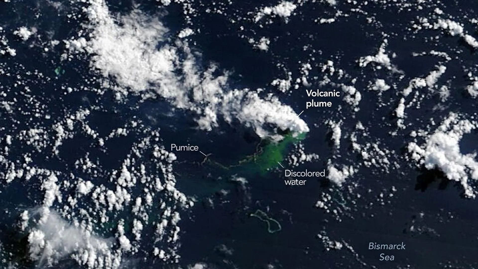
What is clear, however, is the sheer scale of the surface manifestations. The eruption has generated massive columns of steam and ash, vast fields of floating volcanic rock known as pumice rafts, and colossal plumes of discolored, superheated water.
The event underscores a paradigm shift in volcanology: when Earth’s remote oceans conceal their secrets, orbital assets take center stage. "The good news is that there are huge opportunities to explore and learn using both government and commercial satellite platforms already in orbit," said Jim Garvin, chief scientist at NASA’s Goddard Space Flight Center.
The eruption has also ignited intense scientific speculation regarding whether a new permanent island is forming in the Central Bismarck Sea—a rare geological phenomenon that researchers rarely get to document from its inception.
Chronology: A Week of Orbital Surveillance
The sequence of events unfolded rapidly across a matter of days, shifting from subtle seismic disturbances deep in the Earth’s crust to dramatic thermal anomalies visible from space.
- May 8, 2026: Seismometers first register a localized swarm of low-magnitude earthquakes rumbling beneath the Central Bismarck Sea, signaling subterranean magma movement. Within hours, early satellite passes hint at surface disturbances.
- May 9, 2026: NASA’s Aqua and Terra satellites capture striking natural-color imagery of towering white, steam-rich volcanic plumes punching through the marine layer into the troposphere. Simultaneously, the ocean color sensor aboard NASA’s PACE (Plankton, Aerosol, Cloud, Ocean Ecosystem) satellite identifies sprawling areas of discolored, mineral-laden water swirling around the eruption center.
- May 10–11, 2026: Plumes of dark volcanic ash climb several kilometers into the sky. High-resolution imagery captured by the European Space Agency’s Sentinel-2 and the joint NASA/USGS Landsat 9 satellites provides unprecedented views of the turbulent ocean surface. False-color composites utilizing shortwave-infrared bands successfully highlight the intense thermal signatures of the eruption.
- May 12, 2026: The Visible Infrared Imaging Radiometer Suite (VIIRS) instrument aboard the Suomi NPP satellite maps thermal anomalies covering an estimated seven square kilometers of ocean surface, confirming that an immense volume of heat is being released near the surface.
Supporting Data and Expert Analysis
The rapid succession of satellite data has allowed volcanologists and oceanographers to calculate preliminary metrics regarding the eruption’s dynamics. The sheer size of the thermal footprint detected by the Suomi NPP satellite points to a remarkably shallow magma source.
"There must be a lot of hot material near the surface to generate so many thermal anomalies," noted Simon Carn, a volcanologist at Michigan Technological University. "This suggests a fairly shallow eruption vent—much shallower than what’s implied by the existing bathymetry, which shows water depths of several hundred meters or more."
Tectonic Context and Explosivity Constraints
While recent years have yielded catastrophic and highly explosive submarine eruptions—such as the cataclysmic Hunga Tonga-Hunga Ha’apai explosion in 2022 and the Fukutoku-Okanobain eruption in 2021—experts believe the Bismarck Sea event will likely remain comparatively subdued.
Carn attributes this lower risk of extreme explosivity to the unique tectonic setting of Titan Ridge, which lies near the intersection of a transform fault and a back-arc spreading center. "Spreading centers are associated with less explosive activity," Carn explained, "while the most explosive eruptions are usually along subduction zones and involve large stratovolcanoes."
Nevertheless, uncertainty hangs over the longevity of the eruption. Volcanic history in this immediate region shows wild variability in duration. A nearby submarine eruption in 1972 flickered out after just four days, whereas an event roughly 100 kilometers away in the St. Andrew Strait persisted for nearly four years after kicking off in 1957.
Official Responses and Monitoring Protocols
As the eruption continues to evolve, an international coalition of space agencies and research institutions has mobilized to track every square meter of change.
Jim Garvin and his colleagues are spearholding a comprehensive monitoring strategy that relies heavily on synthetic aperture radar (SAR). Because volcanic ash and tropical cloud cover can frequently obscure optical satellite views, radar instruments can peer through the atmosphere day or night to track physical changes in topography.
Garvin plans to utilize radar data from the upcoming NASA-ISRO NISAR satellite and the Canadian Space Agency’s RADARSAT Constellation Mission. These instruments will enable scientists to map any emerging landmass with millimeter-level precision and measure how its physical boundaries expand or contract over time.
"We’re now eagerly waiting to see if a new island is about to be born—something that we’ve only rarely been able to observe with satellites as it happens," Garvin said.
If the volcanic debris manages to breach the ocean surface permanently, it will trigger a complex race between constructive and destructive geological forces. The volcano could successfully build a stable tuff cone anchored by a long-lived vent crater. Conversely, unconsolidated tephra and pumice could be rapidly stripped away by aggressive ocean currents and wave action, causing the nascent island to collapse and erode back beneath the waves. Furthermore, scientists remain vigilant for the possibility of a sudden shift toward greater explosivity should ambient seawater manage to breach a developing, shallow magma chamber.
Implications: A Natural Laboratory for Earth and Space Science
Should a stable landmass successfully anchor itself in the Bismarck Sea, the implications for Earth sciences—and even astrobiology—will be profound.
Garvin envisions the new landmass becoming an exceptional natural laboratory. He frequently refers to the researchers who would study such ephemeral landscapes as "island-nauts." These scientists would have a rare, ground-floor opportunity to monitor how raw, sterile volcanic rock is colonized by pioneer species of plants and microbes, how heavy tropical rainfall and chemical weathering rapidly reshape virgin topographies, and how coastal erosion carves out the island’s morphology over time.
Such processes were studied intensely following the 2022 Hunga Tonga-Hunga Ha’apai eruption, but the Bismarck Sea event could provide an even cleaner, more accessible baseline for ecological succession.
Intriguingly, Garvin also ties these terrestrial field studies directly back to humanity’s broader cosmic ambitions. As space agencies prepare to send human crews back to the Moon via the Artemis program—specifically looking ahead to Artemis IV—studying the birth and degradation of planetary landforms on Earth serves as a vital analogue for planetary geology and astrobiological exploration on other worlds.
"This new eruption could present an even better opportunity for ‘island-naut’ exploration as we prepare to return to the Moon with women and men via Artemis IV," Garvin concluded.
For now, scientists wait and watch the monitors. As the satellites in low-Earth orbit circle the globe, passing silently over the Bismarck Sea, they continue to transmit data from a hidden theater of creation—proving that even in an era of advanced space exploration, planet Earth is still entirely capable of springing geological surprises from the dark of the sea.
