

GAMES, UK / GENOA, ITALY — In a groundbreaking discovery that reshapes our understanding of the southernmost continent’s ancient origins, an international team of researchers has identified a massive, previously unrecognized geological feature buried deep beneath the East Antarctic Ice Sheet. The newly mapped structure—a sprawling, continent-scale network of enormous basins—reveals an intricate, hidden connection among some of the largest subglacial landscapes on Earth.
The finding not only sheds light on the violent, dynamic tectonic forces that forged the supercontinent of Gondwana millions of years ago, but it also provides crucial new context for understanding how the modern ice sheet interacts with the rugged bedrock beneath it. As scientists race to understand how Antarctica will respond to a rapidly warming planet, this hidden subterranean architecture offers vital clues regarding the stability of vulnerable ice sectors.
Main Facts: The East Antarctic Fan-Shaped Basin Province
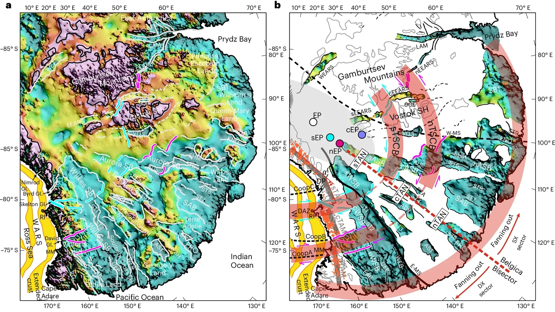
At the heart of the discovery is a vast, interconnected network of depressions concealed beneath ice that in some locations exceeds three kilometers—nearly two miles—in thickness. Together, these immense structural depressions form a coherent, continent-scale, fan-shaped pattern that the research team has formally named the East Antarctic Fan-shaped Basin Province.
While scientists have studied several of these subglacial features individually for decades, this study marks the first time they have been recognized as integral parts of a single, massive geological system. The province encompasses some of the most prominent features of the Antarctic interior, including:
- The Wilkes Basin: A massive, deep subglacial basin stretching toward the coast of Wilkes Land.
- The Aurora Basin: Another colossal structural depression spanning a significant portion of East Antarctica.
- The Vostok Basin: Home to Lake Vostok, the largest known subglacial lake on Earth, isolated beneath thousands of meters of ice for millions of years.
According to the research team, the province was forged through a complex tectonic phenomenon known as distributed rotational extension. This process occurs when continental crust gradually stretches outward from a central point over immense periods of geological time.
To help visualize this mechanics, the researchers compare the pattern to a human hand: the base of the thumb remains relatively fixed while the fingers fan out and spread apart. The spaces left between the spreading fingers mirror the triangular, wedge-like basins created as the Earth’s crust extends and fractures. Geologists believe the East Antarctic Fan-shaped Basin Province may represent one of the largest and most dramatic examples of rotational extension ever documented within continental crust.
Chronology: Unraveling the Tectonic History of Gondwana
The creation of the East Antarctic Fan-shaped Basin Province is not a recent event; rather, it is the product of deep-seated tectonic episodes spanning hundreds of millions of years.
Deep-Time Tectonics and Supercontinent Evolution
The geological history encoded within the newly mapped basins stretches back to the assembly and evolution of ancient supercontinents. Scientists believe the structures developed through multiple tectonic phases associated with the life cycle of Gondwana, the massive southern supercontinent that once united Antarctica, Australia, South America, Africa, India, and Madagascar.
As tectonic plates shifted, collided, and pulled apart, the continental crust beneath what is now East Antarctica underwent severe stretching and deformation. This rotational extension likely played a pivotal role in the later, dramatic breakup of Gondwana, specifically facilitating the continental rifting that ultimately separated Antarctica from Australia.
From Ancient Rifting to Modern Exploration
For generations, the true scale of this tectonic architecture remained entirely hidden. Because over 98 percent of Antarctica is smothered by a massive, multi-kilometer-thick ice sheet, geologists have historically relied on indirect measurements to infer what lies beneath.
In recent years, however, advances in remote sensing, airborne geophysics, and computational modeling have allowed researchers to peel back the icy veneer digitally. By synthesizing decades of scattered data—ranging from satellite gravity surveys to deep seismic soundings—the international research team was able to map the bedrock topography with unprecedented precision, finally linking isolated basins into a unified, continent-spanning province.
Supporting Data and Methodology: Mapping the Subglacial Realm
Uncovering a geological feature buried beneath miles of ice required a monumental multidisciplinary effort. The study was spearheaded by Dr. Egidio Armadillo of the University of Genoa, with vital support from the Italian National Antarctic Research Program (Programma Nazionale di Ricerche Antartiche, PNRA). The international consortium also included prominent institutions such as the United Kingdom’s Durham University, featuring Dr. Guy Paxman from the Department of Geography.
A Multidisciplinary Approach
To overcome the obstacle of the impenetrable ice sheet, the research team integrated a diverse array of geophysical and geological datasets:
- Subglacial Topography: High-resolution elevation models mapping the rugged rock surface beneath the ice.
- Gravity and Magnetic Measurements: Satellite and airborne surveys detecting variations in the density and magnetic properties of the Earth’s crust, which reveal hidden faults, basin boundaries, and crustal blocks.
- Seismic Information: Data tracking how shockwaves travel through the Earth’s interior, providing cross-sectional imagery of the crust and lithosphere.
- Lithospheric Models: Advanced computer simulations modeling the thickness, thermal state, and mechanical behavior of the Antarctic crust.
Reconstructing "Rebounded Topography"
A critical analytical breakthrough in the study involved isolating the weight of the ice itself. Because the sheer mass of the East Antarctic Ice Sheet depresses the Earth’s crust beneath it by hundreds of meters, the bedrock is currently forced downward.
Dr. Guy Paxman led complex calculations to simulate how the landscape would appear if the entire ice sheet were magically removed. Without the immense burden of the ice, the underlying land would experience post-glacial rebound, springing upward by as much as one kilometer.
This reconstructed "rebounded topography" provided the team with a clear, undistorted window into the true elevation, geometry, and orientation of the newly identified geological structure, free from the localized distortions caused by glacial loading.
Official Responses and Expert Perspectives
The publication of the findings has generated considerable excitement within the global geoscience community, offering a fresh perspective on how continents evolve and how interior topography governs continental behavior.
"Recognizing these disparate basins as parts of a single, massive structural province fundamentally changes how we view the tectonic history of East Antarctica," noted Dr. Egidio Armadillo during a press briefing discussing the findings. "It demonstrates that the crust here was subjected to profound, highly organized extensional forces that left a scar spanning thousands of kilometers."
Dr. Guy Paxman emphasized the utility of the rebounded topography models in uncovering hidden geological truths. "When you strip away the ice sheet computationally, a remarkably coherent architectural pattern emerges," Paxman explained. "The way these basins fan out from a central pivot point provides a textbook example of distributed rotational extension on a continental scale, giving us a rare blueprint of deep lithospheric processes."
Representatives from the Italian National Antarctic Research Program praised the collaborative nature of the project, highlighting how international partnerships and cutting-edge remote sensing are unlocking the last great geographical secrets of our planet.
Implications: Tectonics, Climate, and Ice Sheet Stability
While the discovery is a major triumph for structural geology and tectonic history, its relevance extends far beyond the history books. The architecture of the bedrock beneath Antarctica plays a profoundly active role in shaping the modern world—most notably by influencing the behavior of the world’s largest remaining ice sheet.
Controlling Ice Flow and Subglacial Hydrology
The shape, depth, and orientation of the bedrock dictate how glacial ice flows from the high interior toward the ocean. Valleys, troughs, and basins act as natural highways and reservoirs for ice and meltwater.
By mapping the East Antarctic Fan-shaped Basin Province, scientists now have a much clearer picture of the pathways ice takes as it traverses the continent. Furthermore, the province houses critical subglacial hydrological systems, including Lake Vostok. Understanding the boundaries and connectivity of these basins is essential for modeling how water moves beneath the ice, which in turn lubricates the base of glaciers and affects their sliding velocity.
Assessing Climate Change Vulnerability
Perhaps the most pressing implication of the study relates to global sea-level rise. While the East Antarctic Ice Sheet has historically been viewed as relatively stable compared to its more volatile counterpart in West Antarctica, scientists are increasingly recognizing that certain sectors of East Antarctica rest on bedrock that dips below sea level—making them vulnerable to ocean-warming-induced retreat.
The discovery of the Fan-shaped Basin Province highlights regions where the crust has been heavily stretched and thinned by ancient tectonic activity. Areas of thinned crust often correlate with distinct thermal regimes and specific baseline topographies that can influence how vulnerable the overlying ice is to marine-driven melting.
By accurately mapping these hidden basins, glaciologists and climate modelers can drastically improve their predictive simulations. Knowing where deep subglacial troughs lie allows researchers to identify potential weak points along the ice sheet margins, ultimately improving long-term forecasts for global sea-level rise as the Earth’s climate continues to warm.
Conclusion
The identification of the East Antarctic Fan-shaped Basin Province marks a milestone in polar research. By bridging the gap between deep-time geological forces and modern glaciology, scientists have demonstrated that the ancient tectonic past of Antarctica remains intimately tied to its present-day stability. As researchers continue to analyze the data yielded by this massive hidden structure, the frozen continent continues to prove that beneath its icy exterior lies a dynamic, complex history waiting to be fully understood.
