

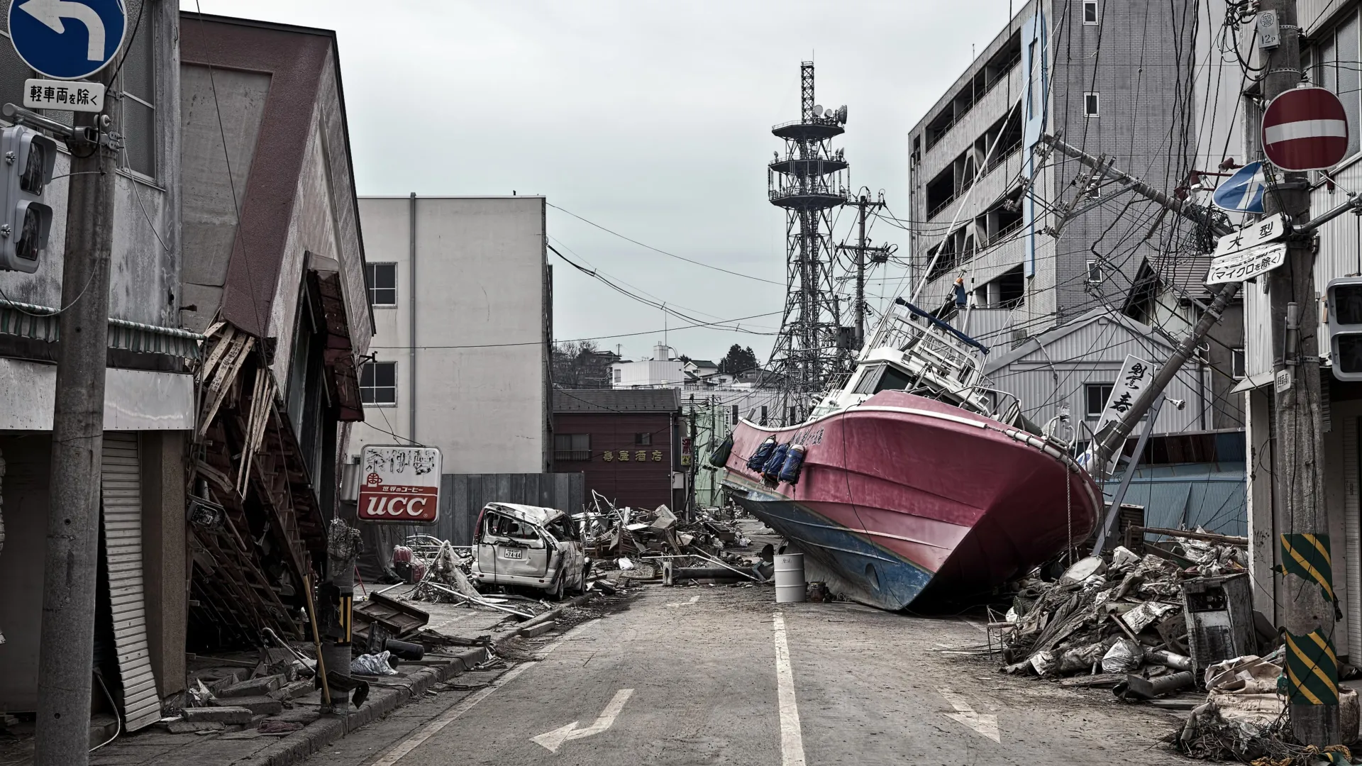
TOKYO / FLAGSTAFF, Ariz. — More than a decade after a catastrophic tremor and subsequent wall of water devastated the Tōhoku region of Japan, scientists have finally unlocked the subterranean mechanics that turned a routine subduction zone earthquake into a historical catastrophe.
A landmark international study published in the prestigious journal Science has revealed the existence of a hidden, highly specialized geological feature resting deep beneath the Pacific Ocean floor: a thin, exceptionally soft layer of clay-rich sediment. This slippery stratum acted as a tectonic "tear line," allowing the fault line to rupture all the way to the trench and violently displace the ocean floor on a scale previously thought impossible by modern seismology.
The discovery not only redefines our understanding of megathrust earthquakes but also introduces critical new variables that could dramatically reshape global tsunami forecasting, coastal infrastructure development, and disaster mitigation strategies worldwide.
Main Facts
The March 11, 2011, Tōhoku earthquake—registering as a staggering magnitude 9.1—remains one of the deadliest and most economically damaging natural disasters in modern human history. Nearly 20,000 human lives were lost, entire coastal communities were erased, and direct economic losses exceeded $200 billion, culminating in the Fukushima Daiichi nuclear disaster.
Until now, the exact mechanism that allowed such an immense amount of energy to propagate all the way to the shallowest reaches of the Japan Trench remained an enigma.
The new study, spearheaded by Northern Arizona University (NAU) associate professor Christine Regalla alongside a multidisciplinary team of over a dozen global researchers, points directly to a 100-foot-thick layer of pelagic clay. Sandwiched between much stronger tectonic plates, this soft, slippery sediment—accumulated over millions of years from microscopic particles drifting down to the deep-ocean floor—functioned as a lubricated slide.
When the tectonic plates shifted in 2011, this weak layer concentrated the seismic rupture along an unnaturally narrow path, allowing the fault to break right up to the seabed. Consequently, the seafloor shifted horizontally and vertically by an extraordinary 130 to 200 feet in a matter of minutes. This extreme displacement acted as an unprecedented piston, thrusting massive volumes of seawater upward and generating the towering, destructive tsunami waves that overwhelmed Japan’s eastern seaboard.
Chronology of the Discovery
To peel back the layers of the deep ocean and uncover the physical culprits behind the 2011 disaster, the scientific community undertook an engineering and geological endeavor of historic proportions.
The Voyage of the Chikyu
Shortly after the disaster, an international consortium of geologists and marine researchers launched an ambitious offshore expedition aboard the Japanese scientific drilling vessel Chikyu. Operating in the punishing depths of the western Pacific, the mission aimed to probe the guts of the Japan Trench.
Using cutting-edge drilling technology, the research team bored approximately 26,000 feet (nearly 5 miles) beneath the surface of the ocean floor, extracting pristine core samples of the fault zone. The sheer depth and technical complexity of the operation earned global recognition, with Guinness World Records officially certifying the expedition as the deepest scientific ocean drilling project ever successfully completed.
Laboratory Analysis and Revelations
Back on land, scientists analyzed the mineralogical, chemical, and physical properties of the recovered sediment cores. They discovered that while most tectonic faults are surrounded by dense, rigid rock that dampens or deflects seismic energy, the Japan Trench featured a unique geological profile: a distinct, highly concentrated band of pelagic clay.
Rather than locking up and requiring massive amounts of stress to break through to the surface—which typically limits the shallow slip of deep-focus earthquakes—this clay layer offered virtually zero resistance once the fault began to move. It acted as an expedited delivery highway for seismic energy, guiding the rupture straight to the trench axis with catastrophic efficiency.
Supporting Data and Technical Insights
To grasp the sheer magnitude of the geological event uncovered by the Chikyu expedition, seismologists rely on comparative data that highlights just how anomalous the 2011 Tōhoku earthquake truly was.
Conventional vs. Megathrust Earthquakes
Most large-scale earthquakes originate deep within the Earth’s lithosphere, where immense heat and pressure cause rock masses to lock, build stress, and suddenly fracture. For example, the magnitude 6.8 Nisqually earthquake that shook the Pacific Northwest in 2001 initiated approximately 32 miles beneath the seafloor, causing deep vibrations but minimal surface deformation.
In stark contrast, the 2011 Tōhoku rupture reached a mere 15 miles below the seafloor before breaking out through the newly discovered clay layer. By breaking so close to the ocean bottom, the earthquake bypassed the dampening effects of thick upper-crustal rock layers.
The Scale of Seafloor Displacement
Co-author Christine Regalla emphasized the unprecedented nature of the displacement:
"That’s equivalent to the entire area between Los Angeles and San Francisco moving 130 to 200 feet in just six minutes. We’ve never seen anything like that in the time we’ve been observing earthquakes. Based on what we understood, we didn’t think that could happen."
Patrick Fulton, an associate professor in Cornell University’s Department of Earth and Atmospheric Sciences and a co-author on the study, noted the structural predisposition of the region:
"At the Japan Trench, the geologic layering basically predetermines where the fault will form. It becomes an extremely focused, extremely weak surface, which makes it easier for ruptures to propagate all the way to the seafloor."
Official Responses and Scientific Consensus
The publication of the findings in Science has sent ripples through the global geophysics community, prompting immediate reassessments from academic institutions, government bodies, and international disaster management organizations.
Geological surveys around the Pacific Rim—frequently referred to as the "Ring of Fire"—are now reviewing historical seismic data from other major subduction zones, such as the Cascadia Subduction Zone in North America, the Aleutian Trench in Alaska, and the Peru-Chile Trench in South America, to determine if similar soft-sediment traps exist elsewhere.
While agencies like the Japan Meteorological Agency (JMA) and international warning networks have long monitored plate movements via GPS stations and offshore pressure sensors, this new research highlights a blind spot: the mineralogy and lithology of the fault zone itself must be mapped with equal precision.
Governments are facing mounting pressure from the scientific community to fund more deep-sea drilling initiatives. Identifying the microscopic structural characteristics of subduction zones is no longer viewed as purely academic; it is now recognized as a critical national security and public safety imperative.
Implications for Future Global Disaster Mitigation
The implications of the Chikyu expedition extend far beyond the coastal waters of Honshu. Because the newly identified pelagic clay layer stretches continuously for hundreds of miles along the Japan Trench, experts warn that the region remains fundamentally more vulnerable to shallow-slip, tsunami-genic earthquakes than legacy models suggested.
A Global Threat Vector
Tsunamis do not respect international borders. As Regalla noted, the geographical reach of a megaquake’s aftermath is inherently global:
"An earthquake and tsunami in Japan doesn’t just impact people who live locally — it also impacts people at the ports and people who live across the ocean. Think about Hawaii: Their most devastating tsunamis come from Japan and Alaska. These are truly global events."
Coastal infrastructure in distant population centers—from the Hawaiian Islands to the West Coast of the United States and Pacific island nations—relies heavily on lead time provided by tsunami warning models. If a fault can rupture to the surface instantaneously via a lubricating clay layer, warning systems have significantly less time to calculate wave heights and issue mandatory evacuations.
Reshaping Engineering and Emergency Preparedness
Armed with this new data, urban planners, civil engineers, and policymakers face the daunting task of translating geological discoveries into actionable defense measures.
- Upgraded Building Codes: Infrastructure standards in seismic zones must account for the possibility of higher-energy, shallow-rupture tsunamis that can overtop existing seawalls.
- Dynamic Evacuation Modeling: Emergency management agencies are updating evacuation routes to assume faster arrival times for tsunami waves generated by low-resistance fault slips.
- Global Risk Mapping: International research partnerships are mobilizing to scan other subduction zones for soft clay layers, aiming to create a comprehensive global atlas of high-risk "tear line" faults.
Despite Japan’s reputation as a global leader in earthquake engineering and disaster preparedness, the 2011 tragedy proved that nature can still surpass human expectations.
"Japan is one of the world leaders in earthquake and tsunami preparation, but even they weren’t prepared for what happened in 2011," Regalla concluded. "We all need to gain a better understanding of where these events might happen in the future. Only then can we make emergency plans that will keep everyone safe."
As researchers continue to analyze the sediment cores retrieved from the deepest reaches of the ocean floor, humanity takes one critical step closer to demystifying the planet’s most violent tectonic forces—turning hidden geologic secrets into life-saving knowledge.
