

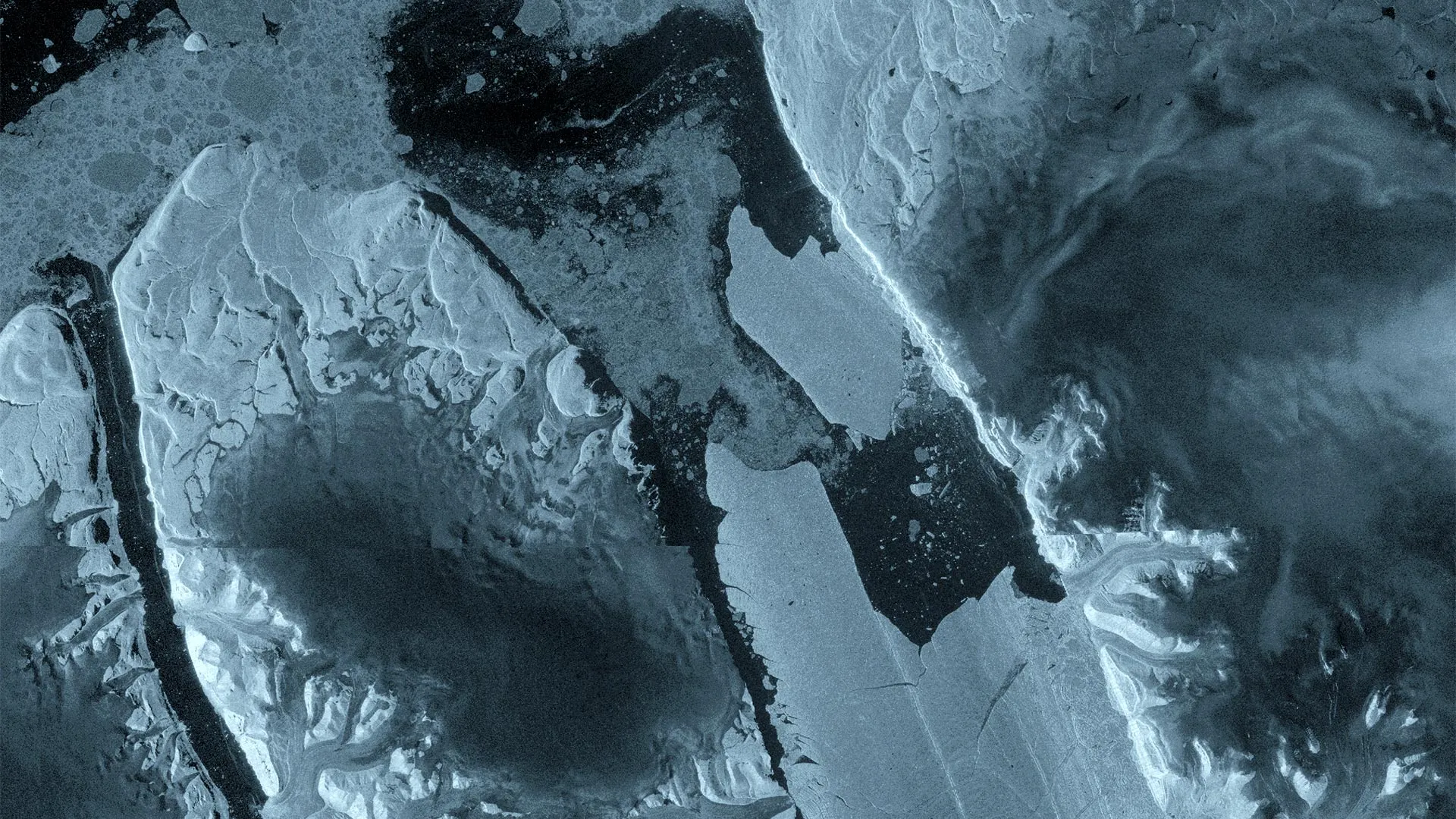
NORTHWEST GREENLAND — In a landmark event underscoring the rapid transformation of the Earth’s polar regions, a massive section of the Petermann Glacier in northwest Greenland has broken away. Captured in high definition by Europe’s Copernicus Sentinel-1 mission, a staggering 76-square-kilometer block of floating ice detached from the glacier’s terminus on August 4, 2026.
The calving event has yielded a tabular iceberg—frequently referred to as an "ice island"—roughly equivalent to the land area of Manhattan. Floating in the Arctic waters with an estimated thickness of up to 150 meters, this colossal slab of ice represents the largest single loss of floating ice from the Petermann Glacier since 2012. Furthermore, it marks the most significant calving event recorded across the entire Arctic region since 2020.
As scientists mobilize to track the colossal ice mass and assess its wider environmental implications, the event has spotlighted the extraordinary capabilities of modern satellite radar technology in documenting the fragile and fast-shifting dynamics of the cryosphere.
Main Facts
The August 4 calving event at Petermann Glacier is a defining glaciological milestone of the decade. The key parameters of the event include:
- Date of Calving: August 4, 2026.
- Ice Loss Volume/Area: A 76-square-kilometer section of the glacier’s floating tongue broke away.
- Ice Island Dimensions: Comparable in size to Manhattan, featuring an estimated thickness of up to 150 meters.
- Historical Context: This is Petermann’s largest ice loss since 2012 and the most substantial Arctic calving event since 2020.
- Observation Technology: Documented primarily via radar imagery from the European Space Agency’s (ESA) Copernicus Sentinel-1 mission, specifically capitalizing on the tandem phase of the Sentinel-1C and Sentinel-1D satellites.
- Scientific Collaboration: Tracked and analyzed by an international research consortium comprising the University of Ottawa (Canada), the Universities of Stirling, Lancaster, and Leeds (UK), and the Canadian Ice Service of Environment and Climate Change Canada. The work is supported by ESA’s FutureEO ARCTEX project.
While tabular icebergs of this sheer magnitude are relatively commonplace in the frigid waters surrounding Antarctica, they remain exceptionally rare phenomena in the Arctic. This rarity transforms the Petermann breakup into an invaluable natural laboratory for polar scientists.
Chronology of a Breakup
The cataclysmic separation on August 4 was not an isolated surprise; rather, it was the culmination of months of structural deterioration within the floating ice tongue.
Spring Deformation and Early Warnings
As early as April 2026, interferometric observations gathered over the Petermann Glacier revealed worrying signs of internal stress. Scientists analyzing radar data detected widespread deformation and deep-seated fractures propagating across the floating ice tongue. These early measurements provided a granular, high-resolution view of mechanical changes that had been quietly developing months before any physical iceberg was visible to standard optical cameras.
An international research team—which has been monitoring the glacier continuously since 2019 under the umbrella of the ARCTEX project—watched closely as expanding fractures began to compromise the structural integrity of the glacier’s eastern flank.
The Final Hours: August 3–4
The pacing of the final collapse caught even seasoned researchers by surprise due to its velocity. On August 3, Sentinel-1 radar imagery revealed a dramatic acceleration in deterioration right along the center of the ice tongue. Deep structural rifts widened visibly over a 24-hour window.
By August 4, the tipping point was reached. The massive structural bridge holding the 76-square-kilometer ice island to the eastern side of the glacier failed completely. The immense tabular berg cleaved away from the parent glacier, beginning its life as a free-floating hazard and research subject in the high Arctic.
Supporting Data and Technological Triumph
The ability to capture this event in such meticulous detail is a testament to the evolution of spaceborne radar technology. Polar environments are notoriously difficult to monitor: they experience months of polar darkness during winter and are frequently blanketed by persistent cloud cover, rendering traditional optical satellites blind for long stretches of time.
The Power of Sentinel-1
The Copernicus Sentinel-1 mission overcomes these natural obstacles by utilizing Synthetic Aperture Radar (SAR). Because radar instruments actively emit their own signals and measure the return echo, they can pierce through thick clouds and operate flawlessly in absolute darkness.
In the case of the Petermann Glacier, researchers were able to leverage a unique operational window: the tandem commissioning phase of the newly launched Sentinel-1D satellite alongside its counterpart, Sentinel-1C. This setup allowed for rare one-day repeat SAR observations.
This high-frequency data stream permitted scientists to construct detailed interferograms—visual maps showing phase shifts in radar waves—that tracked crack propagation and surface motion down to the millimeter. Researchers could accurately observe how the surface of the ice tongue flexed and responded to ocean tides in the tense days leading up to the final fracture.
Future Vulnerabilities: More Ice Islands on the Horizon
Alarmingly, the August 4 event may only be the opening act for the Petermann Glacier. Continued analysis of radar data indicates that existing rifts are still actively spreading across the remaining floating ice tongue.
Scientists have identified two additional massive sections—with estimated areas of approximately 97 square kilometers and 87 square kilometers, respectively—that are showing signs of advanced stress. These sections could potentially detach in the near future if current rifting trends persist.
Official Responses and Expert Perspectives
The historic calving event has elicited intense interest from the global glaciology community, drawing commentary from the graduate researchers and senior scientists closest to the data.
Adam Garbo, a PhD student at the University of Ottawa who has spent years analyzing the region, expressed the sentiment of the research group:
"Petermann Glacier has long been one of Greenland’s largest remaining ice tongues. We’ve anticipated this break for years, and seeing it finally happen is remarkable. It’s a powerful reminder of how quickly these systems can change."
Historically, the Petermann Glacier has produced major ice islands in 2008, 2010, and 2012. However, in the years following the 2012 event, the floating ice tongue had settled into a period of relative stability, punctuated only by minor, localized calving episodes. The 2026 event shatters that decade-long stability.
Dr. Anna Crawford of the University of Stirling highlighted the broader comparative significance of the event:
"While large, tabular icebergs are relatively common in the Southern Ocean around Antarctica, Arctic ice islands are far rarer. By studying Arctic ice islands, we will gain knowledge that can be transferred across polar regions. This is critical for understanding how the calving and deterioration of ice islands impact glacier dynamics, sea-level rise and the ocean environment."
Molly Hammond, a PhD student from the University of Leeds responsible for processing the Sentinel-1 data streams, underscored the excitement of capturing the break in near-real time:
"The changes we observed on Petermann Glacier were occurring very rapidly in the lead-up to the iceberg calving event, so it was incredibly exciting to monitor the crack propagation with interferometry in near-real time. This has demonstrated the incredible value of one-day repeat synthetic aperture data."
Adding institutional perspective, ESA’s Martin Wearing emphasized the critical role of continuous Earth observation infrastructure:
"This type of large tabular iceberg is relatively rare in the Arctic, making this calving event a unique opportunity to study how such a vast ice mass drifts, evolves and eventually breaks apart. Satellite missions such as Sentinel-1 provide the systematic, long-term observations needed to track these changes, helping scientists better understand the processes driving calving and the wider impacts on the polar environment, and ultimately the Earth system as a whole."
Implications: Science, Navigation, and Environmental Security
The consequences of the Petermann Glacier calving event extend far beyond academic interest in glaciology, touching upon maritime safety, oceanography, and global climate monitoring.
Climate and Ocean Dynamics
As the newly freed Manhattan-sized ice island drifts away from the Greenland coast, it will begin a slow process of disintegration and melting. Monitoring this trajectory helps scientists quantify the freshwater flux into the Arctic Ocean. Massive introductions of freshwater can alter local ocean stratification, salinity, and circulation patterns, which in turn influence marine ecosystems and broader climatic feedback loops. Furthermore, studying how the glacier retreats helps researchers refine predictive models concerning the future stability of Greenland’s vast ice sheet and its ultimate contribution to global sea-level rise.
Practical Risks to Navigation and Offshore Infrastructure
While the scientific community views the event as an unparalleled research opportunity, operational agencies are treating the massive ice mass as a serious navigational hazard.
Environment and Climate Change Canada, working in tandem with the Canadian Ice Service, has initiated active tracking protocols to monitor the path of the iceberg. Ice masses of this magnitude pose severe, long-term threats to maritime shipping lanes and offshore industrial infrastructure operating in Arctic waters.
Because the iceberg is roughly 150 meters thick, a substantial portion of its mass sits hidden beneath the ocean surface, leaving it susceptible to deep ocean currents that can drive its movement independently of surface winds. As the ice island drifts over the coming months and years, it is expected to fracture into progressively smaller, harder-to-detect bergs and growlers, extending the navigation hazard window well into the future.
Summary
The fracturing of the Petermann Glacier stands as a stark indicator of dynamic shifts in the high Arctic. Supported by state-of-the-art satellite constellations like Copernicus Sentinel-1 and collaborative international research frameworks like ARCTEX, scientists are uniquely equipped to watch, measure, and learn from these monumental geological events as they unfold—providing essential data for a rapidly warming planet.
